TopoQuest Logo
Do you find TopoQuest useful?
Help keep TopoQuest running and adding new maps/features by donating!
Bitcoin:  19c7KJd3qBynnjoSw5npx9KScwjBe4ifkT
Litecoin:  LXs6TkuXGGXo1vDsWCkWVdjQX94eUKd6ui
Home View Maps Find Maps Find Places Resources & Links


Swan Valley, Idaho Topographic Map

USGS Map Title: Swan Valley, ID
USGS Map MRC: 43111D3
DRG (GeoTIFF) Download: o43111d3.tif


Neighboring USGS Topographic Map Quads:


  Wheaton Mountain, ID  
43111E4
 

  Stouts Mountain, ID  
43111E3
 

  Fourth of July Peak, ID  
43111E2
 

  Conant Valley, ID  
43111D4
 

  Swan Valley, ID  
43111D3
 

  Thompson Peak, ID  
43111D2
 

  Commissary Ridge, ID  
43111C4
 

  Red Ridge, ID  
43111C3
 

  Palisades Dam, ID  
43111C2


Map MRC Location:

N44°
W112°
N44°
W111°
H8 H7 H6 H5 H4 H3 H2 H1
G8 G7 G6 G5 G4 G3 G2 G1
F8 F7 F6 F5 F4 F3 F2 F1
E8 E7 E6 E5 E4 E3 E2 E1
D8 D7 D6 D5 D4 D3 D2 D1
C8 C7 C6 C5 C4 C3 C2 C1
B8 B7 B6 B5 B4 B3 B2 B1
A8 A7 A6 A5 A4 A3 A2 A1
N43°
W112°
N43°
W111°

Swan Valley, ID USGS 1:24K Topographic Map Preview:
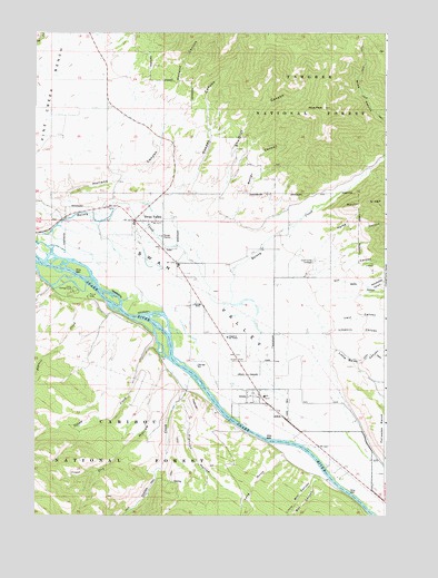
Swan Valley, ID USGS Topographic Map
Click on map above to begin viewing in our Map Viewer.

This topographic map contains these locations and features:
Feature Name Type Latitude Longitude GNIS ID View Map
Baldy CanyonValleyN43.4394°W111.2705°376901View Map
Box CanyonValleyN43.3855°W111.2788°378144View Map
ChapelInThe ValleyChurchN43.4241°W111.3102°379187View Map
City of IrwinCivilN43.4083°W111.2851°2410118View Map
City of Swan ValleyCivilN43.4445°W111.3286°2412020View Map
Cromwell CanyonValleyN43.4769°W111.2502°380070View Map
Dry CanyonValleyN43.4346°W111.2836°380796View Map
Dry HollowValleyN43.4155°W111.3308°380885View Map
Falls CampgroundLocaleN43.4369°W111.3622°381567View Map
FlatironSummitN43.4041°W111.3199°397708View Map
Flatiron HollowValleyN43.4069°W111.3247°381844View Map
Holland CanyonValleyN43.4585°W111.3633°383256View Map
Horse CanyonValleyN43.4496°W111.2783°383360View Map
Huskey AirportAirportN43.4169°W111.2848°2443846View Map
Indian CreekStreamN43.4130°W111.3224°383656View Map
IrwinPopulated PlaceN43.4085°W111.2994°397812View Map
Irwin CanyonValleyN43.4271°W111.2780°383772View Map
Irwin Post OfficePost OfficeN43.4074°W111.2954°2781804View Map
Kopp CanyonValleyN43.4962°W111.3298°2512540View Map
Limekiln CanyonValleyN43.4255°W111.2774°384668View Map
Little Baldy CanyonValleyN43.4155°W111.2711°384713View Map
Little Box CanyonValleyN43.3860°W111.2805°384747View Map
Long GulchValleyN43.3908°W111.2866°386051View Map
Oakden CanyonValleyN43.4635°W111.3294°387908View Map
Oakden CreekStreamN43.4577°W111.3277°399171View Map
Palisades Creek Winter Range Wildlife Habitate AreaReserveN43.3941°W111.2541°401098View Map
Papoose CreekStreamN43.4371°W111.3688°388156View Map
Rocky CanyonValleyN43.4299°W111.2574°389542View Map
Roller CanyonValleyN43.4563°W111.3172°389581View Map
Ross PeakSummitN43.4874°W111.2786°389625View Map
Shurtliff CanyonValleyN43.4585°W111.3219°390395View Map
Shurtliff CreekStreamN43.4533°W111.3197°399216View Map
Squaw CreekStreamN43.4208°W111.3338°391287View Map
Swan ValleyValleyN43.4452°W111.3730°391732View Map
Swan ValleyPopulated PlaceN43.4560°W111.3416°397226View Map
Swan Valley CemeteryCemeteryN43.4410°W111.2755°391733View Map
Swan Valley Elementary SchoolSchoolN43.4060°W111.2936°401169View Map
Swan Valley Fire District 2BuildingN43.4537°W111.3384°2619074View Map
Swan Valley Post OfficePost OfficeN43.4501°W111.3392°2781790View Map
Swan Valley Ranger StationLocaleN43.4480°W111.3299°399195View Map
Woodpecker CanyonValleyN43.4380°W111.2636°393672View Map

Note: Coordinates in the location and feature list above are referenced to NAD83 datum.


Copyright (C) 2008-2025 Ryan Niemi / Sunset Dynamics ... All Rights Reserved