TopoQuest Logo
Do you find TopoQuest useful?
Help keep TopoQuest running and adding new maps/features by donating!
Bitcoin:  19c7KJd3qBynnjoSw5npx9KScwjBe4ifkT
Litecoin:  LXs6TkuXGGXo1vDsWCkWVdjQX94eUKd6ui
Home View Maps Find Maps Find Places Resources & Links


Palm Valley, Florida Topographic Map

USGS Map Title: Palm Valley, FL
USGS Map MRC: 30081B4
DRG (GeoTIFF) Download: o30081b4.tif


Neighboring USGS Topographic Map Quads:


  Arlington, FL  
30081C5
 

  Jacksonville Beach, FL  
30081C4


  Bayard, FL  
30081B5
 

  Palm Valley, FL  
30081B4
 

  Mickler Landing, FL  
30081B3
 

  Orangedale, FL  
30081A5
 

  Durbin, FL  
30081A4
 

  South Ponte Vedra Beach, FL  
30081A3


Map MRC Location:

N31°
W82°
N31°
W81°
H8 H7 H6 H5 H4 H3 H2 H1
G8 G7 G6 G5 G4 G3 G2 G1
F8 F7 F6 F5 F4 F3 F2 F1
E8 E7 E6 E5 E4 E3 E2 E1
D8 D7 D6 D5 D4 D3 D2 D1
C8 C7 C6 C5 C4 C3 C2 C1
B8 B7 B6 B5 B4 B3 B2 B1
A8 A7 A6 A5 A4 A3 A2 A1
N30°
W82°
N30°
W81°

Palm Valley, FL USGS 1:24K Topographic Map Preview:
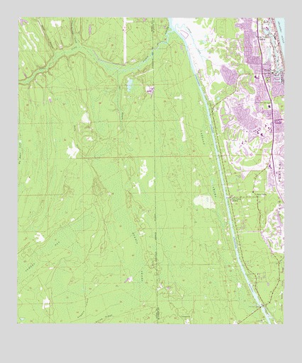
Palm Valley, FL USGS Topographic Map
Click on map above to begin viewing in our Map Viewer.

This topographic map contains these locations and features:
Feature Name Type Latitude Longitude GNIS ID View Map
Agneda Segui GrantCivilN30.2308°W81.4740°304053View Map
Boggy BranchStreamN30.2352°W81.4818°279158View Map
Box BranchStreamN30.2280°W81.4501°279298View Map
Cabbage CreekStreamN30.2450°W81.4256°307903View Map
Cabbage SwampSwampN30.1779°W81.4073°307904View Map
Cedar Swamp CreekStreamN30.2380°W81.4712°280228View Map
Cultural Center at Ponte VedraLocaleN30.2139°W81.3797°2451941View Map
Daniel Clarke GrantCivilN30.1772°W81.4554°304048View Map
Deep Forest AirportAirportN30.2449°W81.4509°309522View Map
Durbin SwampSwampN30.1347°W81.4471°281890View Map
George I F Clarke GrantCivilN30.1597°W81.4718°304044View Map
GIF Clarke GrantCivilN30.1316°W81.4593°304052View Map
Harbor City Municipal Golf CourseLocaleN30.2376°W81.4422°2449469View Map
Ibis CoveBayN30.2289°W81.3775°307992View Map
James Clarke GrantCivilN30.1661°W81.4509°304049View Map
James Hall GrantCivilN30.1425°W81.4740°304051View Map
Lake VedraLakeN30.2412°W81.3805°308161View Map
Lewis Mattair GrantCivilN30.2011°W81.4601°304050View Map
Palm ValleyPopulated PlaceN30.1775°W81.3876°308066View Map
Palm Valley BridgeBridgeN30.1325°W81.3851°308067View Map
Palm Valley Census Designated PlaceCensusN30.2011°W81.3948°2403392View Map
Palm Valley LandingPopulated PlaceN30.1758°W81.4004°308068View Map
Pedro Cocifacio GrantCivilN30.1302°W81.4545°304047View Map
Ponte VedraPopulated PlaceN30.2275°W81.3801°308083View Map
Ponte Vedra BeachPopulated PlaceN30.2397°W81.3856°308084View Map
Ponte Vedra Beach Post OfficePost OfficeN30.1948°W81.3825°2451946View Map
Ponte Vedra DivisionCivilN30.1964°W81.3803°1935902View Map
Ponte Vedra Palm Valley - Rawlings Elementary SchoolSchoolN30.2154°W81.3833°308086View Map
Powers BaySwampN30.1605°W81.4736°289280View Map
Ragged IslandIslandN30.1314°W81.4676°289431View Map
Saint Johns County Fire Rescue Station 1 Palm ValleyBuildingN30.1774°W81.3990°2644227View Map
Saint Johns County Fire Rescue Station 10 Ponte VedraBuildingN30.2254°W81.3864°2644240View Map
Saint Johns County Public Library System Ponte Vedra Beach Branch LibraryBuildingN30.2246°W81.3852°2451942View Map
Saint Johns County Sheriff's Office - Point Vedra Field OfficeBuildingN30.1921°W81.3826°2333185View Map
Samuel Fairbanks GrantCivilN30.1508°W81.4954°304057View Map
Sawgrass Village Shopping CenterLocaleN30.2043°W81.3816°2476282View Map
Scrub RidgeRidgeN30.1261°W81.4604°290774View Map
Sherbrooke Golf and Country ClubLocaleN30.1655°W81.3776°2451944View Map
Tolomato (historical)Populated PlaceN30.2336°W81.4665°294477View Map
TwentymilePopulated PlaceN30.1266°W81.4217°308158View Map

Note: Coordinates in the location and feature list above are referenced to NAD83 datum.


Copyright (C) 2008-2024 Ryan Niemi / Sunset Dynamics ... All Rights Reserved