TopoQuest Logo
Do you find TopoQuest useful?
Help keep TopoQuest running and adding new maps/features by donating!
Bitcoin:  19c7KJd3qBynnjoSw5npx9KScwjBe4ifkT
Litecoin:  LXs6TkuXGGXo1vDsWCkWVdjQX94eUKd6ui
Home View Maps Find Maps Find Places Resources & Links


Palouse, Washington Topographic Map

USGS Map Title: Palouse, WA
USGS Map MRC: 46117H1
DRG (GeoTIFF) Download: o46117h1.tif


Neighboring USGS Topographic Map Quads:


  Garfield, WA  
47117A2
 

  Farmington, WA  
47117A1
 

  Mission Mountain, ID  
47116A8
 

  Elberton, WA  
46117H2
 

  Palouse, WA  
46117H1
 

  Potlatch, ID  
46116H8
 

  Albion, WA  
46117G2
 

  Viola, ID  
46117G1
 

  Robinson Lake, ID  
46116G8


Map MRC Location:

N47°
W118°
N47°
W117°
H8 H7 H6 H5 H4 H3 H2 H1
G8 G7 G6 G5 G4 G3 G2 G1
F8 F7 F6 F5 F4 F3 F2 F1
E8 E7 E6 E5 E4 E3 E2 E1
D8 D7 D6 D5 D4 D3 D2 D1
C8 C7 C6 C5 C4 C3 C2 C1
B8 B7 B6 B5 B4 B3 B2 B1
A8 A7 A6 A5 A4 A3 A2 A1
N46°
W118°
N46°
W117°

Palouse, WA USGS 1:24K Topographic Map Preview:
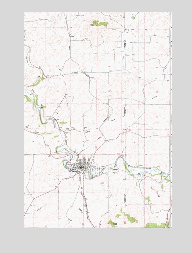
Palouse, WA USGS Topographic Map
Click on map above to begin viewing in our Map Viewer.

This topographic map contains these locations and features:
Feature Name Type Latitude Longitude GNIS ID View Map
CedarLocaleN46.9696°W117.1205°1511476View Map
Cedar CreekStreamN46.9549°W117.1246°379092View Map
City of PalouseCivilN46.9103°W117.0752°2411364View Map
Duffield CreekStreamN46.9299°W117.0910°380919View Map
Garfield - Palouse High SchoolSchoolN46.9126°W117.0710°1515583View Map
Greenwood CemeteryCemeteryN46.9044°W117.0694°1505288View Map
GrinnellPopulated PlaceN46.9621°W117.0688°1511015View Map
HornLocaleN46.9368°W117.0546°1511475View Map
Jamestown (historical)Populated PlaceN46.9968°W117.0335°399084View Map
LadowPopulated PlaceN46.9857°W117.0854°1511081View Map
Ladow ButteSummitN46.9921°W117.0643°1512363View Map
LairdsPopulated PlaceN46.9138°W117.0874°1511083View Map
PalousePopulated PlaceN46.9102°W117.0757°1531058View Map
Palouse Elementary SchoolSchoolN46.9129°W117.0714°1515582View Map
Palouse Fire DepartmentBuildingN46.9106°W117.0762°2643918View Map
Palouse Police DepartmentBuildingN46.9099°W117.0764°2721959View Map
Palouse Post OfficePost OfficeN46.9102°W117.0745°2769202View Map
Ringo ButteSummitN46.8771°W117.0499°1512606View Map
Schoepflin AirportAirportN46.8842°W117.0755°2443395View Map
Viola RidgeRidgeN46.8946°W117.0154°375702View Map
WellesleyLocaleN46.9068°W117.0071°399705View Map
Whitman County Fire District 4 Palouse Fire Department and Emergency Medical Services Station 1BuildingN46.9108°W117.0799°2643689View Map
Yellow Dog (historical)Populated PlaceN46.9791°W117.0338°399604View Map

Note: Coordinates in the location and feature list above are referenced to NAD83 datum.


Copyright (C) 2008-2025 Ryan Niemi / Sunset Dynamics ... All Rights Reserved