TopoQuest Logo
Do you find TopoQuest useful?
Help keep TopoQuest running and adding new maps/features by donating!
Bitcoin:  19c7KJd3qBynnjoSw5npx9KScwjBe4ifkT
Litecoin:  LXs6TkuXGGXo1vDsWCkWVdjQX94eUKd6ui
Home View Maps Find Maps Find Places Resources & Links


Pantego, North Carolina Topographic Map

USGS Map Title: Pantego, NC
USGS Map MRC: 35076E6
DRG (GeoTIFF) Download: o35076e6.tif


Neighboring USGS Topographic Map Quads:


  Hoke, NC  
35076F7
 

  Pike Road, NC  
35076F6
 

  Pungo Lake, NC  
35076F5
 

  Pinetown, NC  
35076E7
 

  Pantego, NC  
35076E6
 

  Belhaven, NC  
35076E5
 

  Bath, NC  
35076D7
 

  Ransomville, NC  
35076D6
 

  Pamlico Beach, NC  
35076D5


Map MRC Location:

N36°
W77°
N36°
W76°
H8 H7 H6 H5 H4 H3 H2 H1
G8 G7 G6 G5 G4 G3 G2 G1
F8 F7 F6 F5 F4 F3 F2 F1
E8 E7 E6 E5 E4 E3 E2 E1
D8 D7 D6 D5 D4 D3 D2 D1
C8 C7 C6 C5 C4 C3 C2 C1
B8 B7 B6 B5 B4 B3 B2 B1
A8 A7 A6 A5 A4 A3 A2 A1
N35°
W77°
N35°
W76°

Pantego, NC USGS 1:24K Topographic Map Preview:
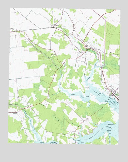
Pantego, NC USGS Topographic Map
Click on map above to begin viewing in our Map Viewer.

This topographic map contains these locations and features:
Feature Name Type Latitude Longitude GNIS ID View Map
Archbell PointCapeN35.5007°W76.6669°980278View Map
Beaufort Elementary SchoolSchoolN35.5857°W76.6674°1006848View Map
Belhaven Memorial MuseumBuildingN35.5416°W76.6255°1024956View Map
Belhaven Post OfficePost OfficeN35.5490°W76.6260°2505331View Map
Bellhaven Water Treatment PlantLocaleN35.5603°W76.6251°2505994View Map
Bishops CrossPopulated PlaceN35.6110°W76.6777°981505View Map
Bivalve PointCapeN35.5335°W76.6299°981507View Map
Broad CreekStreamN35.5491°W76.6577°981931View Map
Broad Creek CanalCanalN35.5893°W76.7208°981938View Map
Broad Creek ChurchChurchN35.5821°W76.6966°981940View Map
Cedar IslandIslandN35.5402°W76.6416°982876View Map
Cedar PointCapeN35.5474°W76.6444°982895View Map
Clark CreekStreamN35.5402°W76.6602°983216View Map
Cuckolds CreekStreamN35.5716°W76.6516°983827View Map
Deep RunStreamN35.5499°W76.6891°984095View Map
First Assembly of God ChurchChurchN35.5521°W76.6278°2505817View Map
Five Pines IslandIslandN35.5466°W76.6563°985132View Map
Fluhardt PointCapeN35.5443°W76.6627°985252View Map
GaylordPopulated PlaceN35.6057°W76.7491°1020409View Map
Graveyard PointCapeN35.5010°W76.7085°985981View Map
Gum PointCapeN35.5402°W76.6274°986226View Map
Hell SwampSwampN35.5285°W76.7010°986603View Map
Ingoes CreekStreamN35.5602°W76.6624°987375View Map
Little CreekStreamN35.5082°W76.6355°988603View Map
Norflick ShoreBeachN35.5099°W76.6360°991177View Map
Oddfellows CemeteryCemeteryN35.5542°W76.6337°1008337View Map
Oddfellows CemeteryCemeteryN35.5543°W76.6336°1008192View Map
Old Mill CreekStreamN35.5013°W76.7158°991584View Map
PantegoPopulated PlaceN35.5891°W76.6622°991817View Map
Pantego ChurchChurchN35.5866°W76.6702°1008159View Map
Pantego Junior High SchoolSchoolN35.5913°W76.6547°1006851View Map
Pantego Post OfficePost OfficeN35.5884°W76.6578°2774222View Map
Pantego Volunteer Fire DepartmentBuildingN35.5881°W76.6632°2639548View Map
Pentego Post OfficePost OfficeN35.5884°W76.6578°2780610View Map
Persimmon Tree PointCapeN35.5193°W76.6294°992074View Map
Pungo FisheriesLocaleN35.5492°W76.7306°2650339View Map
Pungo SwampStreamN35.5316°W76.7330°992914View Map
Roper DitchCanalN35.5463°W76.6338°993675View Map
Scott CreekStreamN35.5068°W76.6674°994427View Map
Shoemaker CreekStreamN35.5435°W76.6305°994759View Map
Smith CreekStreamN35.5046°W76.6713°994965View Map
SmithtownPopulated PlaceN35.5216°W76.6638°995010View Map
Spady PointCapeN35.5029°W76.6710°995264View Map
Stotesberry PointCapeN35.5527°W76.6591°995590View Map
SwindellPopulated PlaceN35.6235°W76.6899°1022872View Map
The NarrowsChannelN35.5021°W76.6685°995992View Map
Town of PantegoCivilN35.5874°W76.6594°2407072View Map
Township of PantegoCivilN35.5900°W76.7004°1026409View Map
Vale CreekStreamN35.5171°W76.6480°996572View Map
West Belhaven Church of ChristChurchN35.5510°W76.6355°2506309View Map
WilkinsonPopulated PlaceN35.6093°W76.6988°1023256View Map
Windmill PointCapeN35.5124°W76.6380°997474View Map
YeatesvillePopulated PlaceN35.5285°W76.7402°997700View Map

Note: Coordinates in the location and feature list above are referenced to NAD83 datum.


Copyright (C) 2008-2025 Ryan Niemi / Sunset Dynamics ... All Rights Reserved