TopoQuest Logo
Do you find TopoQuest useful?
Help keep TopoQuest running and adding new maps/features by donating!
Bitcoin:  19c7KJd3qBynnjoSw5npx9KScwjBe4ifkT
Litecoin:  LXs6TkuXGGXo1vDsWCkWVdjQX94eUKd6ui
Home View Maps Find Maps Find Places Resources & Links


Pike Road, North Carolina Topographic Map

USGS Map Title: Pike Road, NC
USGS Map MRC: 35076F6
DRG (GeoTIFF) Download: o35076f6.tif


Neighboring USGS Topographic Map Quads:


  Plymouth West, NC  
35076G7
 

  Plymouth East, NC  
35076G6
 

  Roper South, NC  
35076G5
 

  Hoke, NC  
35076F7
 

  Pike Road, NC  
35076F6
 

  Pungo Lake, NC  
35076F5
 

  Pinetown, NC  
35076E7
 

  Pantego, NC  
35076E6
 

  Belhaven, NC  
35076E5


Map MRC Location:

N36°
W77°
N36°
W76°
H8 H7 H6 H5 H4 H3 H2 H1
G8 G7 G6 G5 G4 G3 G2 G1
F8 F7 F6 F5 F4 F3 F2 F1
E8 E7 E6 E5 E4 E3 E2 E1
D8 D7 D6 D5 D4 D3 D2 D1
C8 C7 C6 C5 C4 C3 C2 C1
B8 B7 B6 B5 B4 B3 B2 B1
A8 A7 A6 A5 A4 A3 A2 A1
N35°
W77°
N35°
W76°

Pike Road, NC USGS 1:24K Topographic Map Preview:
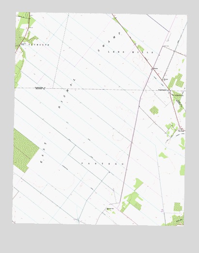
Pike Road, NC USGS Topographic Map
Click on map above to begin viewing in our Map Viewer.

This topographic map contains these locations and features:
Feature Name Type Latitude Longitude GNIS ID View Map
Donald's Air Park IncAirportN35.7345°W76.6681°2679243View Map
Donalds Air ParkBuildingN35.7335°W76.6697°2506025View Map
East Dismal SwampSwampN35.7243°W76.6941°984492View Map
Flat SwampSwampN35.7368°W76.7480°1003431View Map
Johnson SidingPopulated PlaceN35.6582°W76.6674°1005558View Map
Morning Star ChurchChurchN35.6346°W76.6810°990252View Map
Morrisons StorePopulated PlaceN35.6946°W76.6335°1005229View Map
Number 2 CanalCanalN35.6763°W76.7113°1023673View Map
Number Three CanalCanalN35.6827°W76.7072°1023676View Map
Oregon CanalCanalN35.6771°W76.6333°991684View Map
Pike RoadPopulated PlaceN35.6829°W76.6274°992192View Map
Pungo River Volunteer Fire DepartmentBuildingN35.6830°W76.6285°2638616View Map
Sixteen Mile SidingLocaleN35.7179°W76.6491°1003452View Map
Sixth LandingLocaleN35.6677°W76.6644°1008144View Map
Sixth SidingPopulated PlaceN35.6746°W76.6630°1005230View Map
Tareover BridgeBridgeN35.7482°W76.7397°1018710View Map
Upper Pungo SchoolSchoolN35.6802°W76.6288°1006846View Map
Van Swamp BridgeBridgeN35.7304°W76.7469°996578View Map
WenonaPopulated PlaceN35.7182°W76.6494°1006404View Map
Wenona ChurchChurchN35.7118°W76.6416°996957View Map

Note: Coordinates in the location and feature list above are referenced to NAD83 datum.


Copyright (C) 2008-2025 Ryan Niemi / Sunset Dynamics ... All Rights Reserved