TopoQuest Logo
Do you find TopoQuest useful?
Help keep TopoQuest running and adding new maps/features by donating!
Bitcoin:  19c7KJd3qBynnjoSw5npx9KScwjBe4ifkT
Litecoin:  LXs6TkuXGGXo1vDsWCkWVdjQX94eUKd6ui
Home View Maps Find Maps Find Places Resources & Links


Paris, Idaho Topographic Map

USGS Map Title: Paris, ID
USGS Map MRC: 42111B4
DRG (GeoTIFF) Download: o42111b4.tif


Neighboring USGS Topographic Map Quads:


  Midnight Mountain, ID  
42111C5
 

  Ovid, ID  
42111C4
 

  Montpelier, ID  
42111C3
 

  Paris Peak, ID  
42111B5
 

  Paris, ID  
42111B4
 

  Dingle, ID  
42111B3
 

  Egan Basin, ID  
42111A5
 

  Saint Charles, ID  
42111A4
 

  Bear Lake North, ID  
42111A3


Map MRC Location:

N43°
W112°
N43°
W111°
H8 H7 H6 H5 H4 H3 H2 H1
G8 G7 G6 G5 G4 G3 G2 G1
F8 F7 F6 F5 F4 F3 F2 F1
E8 E7 E6 E5 E4 E3 E2 E1
D8 D7 D6 D5 D4 D3 D2 D1
C8 C7 C6 C5 C4 C3 C2 C1
B8 B7 B6 B5 B4 B3 B2 B1
A8 A7 A6 A5 A4 A3 A2 A1
N42°
W112°
N42°
W111°

Paris, ID USGS 1:24K Topographic Map Preview:
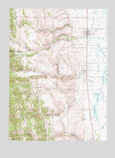
Paris, ID USGS Topographic Map
Click on map above to begin viewing in our Map Viewer.

This topographic map contains these locations and features:
Feature Name Type Latitude Longitude GNIS ID View Map
Bear Lake County Sheriff's OfficeBuildingN42.2279°W111.4006°2722393View Map
Bear Lake Junior High School (historical)SchoolN42.2263°W111.3991°396088View Map
Bear Lake Volunteer Fire Protection District Station 1BuildingN42.2279°W111.4006°2619024View Map
Big CreekStreamN42.1380°W111.3799°377477View Map
BloomingtonPopulated PlaceN42.1919°W111.4013°377877View Map
Bloomington Post OfficePost OfficeN42.1880°W111.4017°2781783View Map
Boulder MineMineN42.2291°W111.4963°378103View Map
City of BloomingtonCivilN42.1908°W111.4042°2409866View Map
City of ParisCivilN42.2273°W111.4032°2411370View Map
Clark MineMineN42.1488°W111.4513°379371View Map
Crib SpringSpringN42.1340°W111.4531°380063View Map
Dry CreekStreamN42.1722°W111.4141°380812View Map
Emerson SchoolSchoolN42.2288°W111.4005°381452View Map
First HollowValleyN42.2344°W111.4894°381734View Map
Fourth HollowValleyN42.2477°W111.4944°381979View Map
Jarvis SpringSpringN42.1911°W111.4828°383858View Map
Limekiln ForkStreamN42.1297°W111.4855°384671View Map
Little CanyonValleyN42.1860°W111.4369°384764View Map
ParisPopulated PlaceN42.2271°W111.4010°388197View Map
Paris CanyonValleyN42.2210°W111.4088°388198View Map
Paris DivisionCivilN42.1976°W111.4530°1936783View Map
Paris Elementary SchoolSchoolN42.2263°W111.3991°401075View Map
Paris Post OfficePost OfficeN42.2282°W111.4006°2781760View Map
Paris SpringSpringN42.2090°W111.4988°397978View Map
Pine FlatFlatN42.2260°W111.4716°388509View Map
Second HollowValleyN42.2388°W111.4913°390085View Map
Sleight CanyonValleyN42.2344°W111.4177°390593View Map
Telegraph HollowValleyN42.2060°W111.4888°391889View Map
Third HollowValleyN42.2424°W111.4924°392008View Map
Worm CreekStreamN42.1635°W111.4113°393698View Map

Note: Coordinates in the location and feature list above are referenced to NAD83 datum.


Copyright (C) 2008-2024 Ryan Niemi / Sunset Dynamics ... All Rights Reserved