TopoQuest Logo
Do you find TopoQuest useful?
Help keep TopoQuest running and adding new maps/features by donating!
Bitcoin:  19c7KJd3qBynnjoSw5npx9KScwjBe4ifkT
Litecoin:  LXs6TkuXGGXo1vDsWCkWVdjQX94eUKd6ui
Home View Maps Find Maps Find Places Resources & Links


Parks, Arkansas Topographic Map

USGS Map Title: Parks, AR
USGS Map MRC: 34093G8
DRG (GeoTIFF) Download: o34093g8.tif


Neighboring USGS Topographic Map Quads:


  Waldron, AR  
34094H1
 

  Bee Mountain, AR  
34093H8
 

  Freedom Mountain, AR  
34093H7
 

  Boles, AR  
34094G1
 

  Parks, AR  
34093G8
 

  Harvey, AR  
34093G7
 

  Y City, AR  
34094F1
 

  Buck Knob, AR  
34093F8
 

  Brushy Creek Mountain, AR  
34093F7


Map MRC Location:

N35°
W94°
N35°
W93°
H8 H7 H6 H5 H4 H3 H2 H1
G8 G7 G6 G5 G4 G3 G2 G1
F8 F7 F6 F5 F4 F3 F2 F1
E8 E7 E6 E5 E4 E3 E2 E1
D8 D7 D6 D5 D4 D3 D2 D1
C8 C7 C6 C5 C4 C3 C2 C1
B8 B7 B6 B5 B4 B3 B2 B1
A8 A7 A6 A5 A4 A3 A2 A1
N34°
W94°
N34°
W93°

Parks, AR USGS 1:24K Topographic Map Preview:
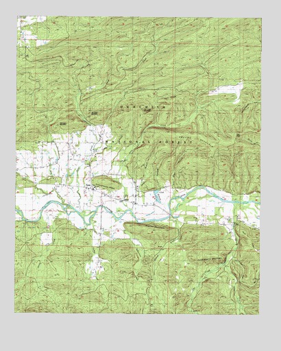
Parks, AR USGS Topographic Map
Click on map above to begin viewing in our Map Viewer.

This topographic map contains these locations and features:
Feature Name Type Latitude Longitude GNIS ID View Map
Bill Hunt MountainSummitN34.8326°W93.9563°70684View Map
Boston CreekStreamN34.7893°W93.9224°70771View Map
Brushy MountainRidgeN34.8254°W93.9069°70871View Map
Catalpa CreekStreamN34.8187°W93.9608°71035View Map
Cow CreekStreamN34.7715°W93.8924°71259View Map
Daily CreekStreamN34.7940°W93.9433°76741View Map
Gilbreath MountainSummitN34.8312°W93.9730°71750View Map
Haney CreekStreamN34.7934°W93.9694°71897View Map
Hart RidgeRidgeN34.8398°W93.9196°71925View Map
Hawkins CemeteryCemeteryN34.8201°W93.9708°71947View Map
Hazel CreekStreamN34.7920°W93.9680°71951View Map
High PeakSummitN34.8276°W93.8821°72005View Map
Huckleberry MountainSummitN34.7743°W93.9010°72105View Map
Hughes MountainSummitN34.7840°W93.9310°72116View Map
Jameson CemeteryCemeteryN34.8106°W93.9741°72169View Map
John Allen HollowValleyN34.7990°W93.9194°72195View Map
Keener ChurchChurchN34.8095°W93.9996°72238View Map
Little Cedar CreekStreamN34.7970°W93.8888°72378View Map
Little Flat BranchStreamN34.7776°W93.8880°72393View Map
Mud CreekStreamN34.7962°W93.9766°72800View Map
ParksPopulated PlaceN34.8020°W93.9608°77956View Map
Parks Baptist ChurchChurchN34.8043°W93.9610°66318View Map
Parks CemeteryCemeteryN34.8034°W93.9605°66319View Map
Parks Methodist ChurchChurchN34.8026°W93.9641°66320View Map
Parks Post OfficePost OfficeN34.8023°W93.9615°84376View Map
Parks School (historical)SchoolN34.8032°W93.9596°66321View Map
Parks Volunteer Fire Department Station 1BuildingN34.8037°W93.9599°2116936View Map
Robertson CreekStreamN34.7893°W93.9380°73318View Map
Salt Log MountainSummitN34.8368°W93.9377°73467View Map
Schoolhouse RidgeSummitN34.8057°W93.9546°73494View Map
Snow BranchStreamN34.7937°W93.9405°73634View Map
Township of KeenerCivilN34.8196°W93.9977°2406954View Map
Township of LambCivilN34.8693°W93.9913°69070View Map
Township of ParksCivilN34.8118°W93.9277°69077View Map
Turkey CreekStreamN34.7907°W93.9605°73902View Map
Williams BranchStreamN34.7982°W93.9213°74157View Map

Note: Coordinates in the location and feature list above are referenced to NAD83 datum.


Copyright (C) 2008-2025 Ryan Niemi / Sunset Dynamics ... All Rights Reserved