TopoQuest Logo
Do you find TopoQuest useful?
Help keep TopoQuest running and adding new maps/features by donating!
Bitcoin:  19c7KJd3qBynnjoSw5npx9KScwjBe4ifkT
Litecoin:  LXs6TkuXGGXo1vDsWCkWVdjQX94eUKd6ui
Home View Maps Find Maps Find Places Resources & Links


Freedom Mountain, Arkansas Topographic Map

USGS Map Title: Freedom Mountain, AR
USGS Map MRC: 34093H7
DRG (GeoTIFF) Download: o34093h7.tif


Neighboring USGS Topographic Map Quads:


  Golden City, AR  
35093A8
 

  Sugar Grove, AR  
35093A7
 

  Blue Mountain Dam, AR  
35093A6
 

  Bee Mountain, AR  
34093H8
 

  Freedom Mountain, AR  
34093H7
 

  Gravelly, AR  
34093H6
 

  Parks, AR  
34093G8
 

  Harvey, AR  
34093G7
 

  Little Texas, AR  
34093G6


Map MRC Location:

N35°
W94°
N35°
W93°
H8 H7 H6 H5 H4 H3 H2 H1
G8 G7 G6 G5 G4 G3 G2 G1
F8 F7 F6 F5 F4 F3 F2 F1
E8 E7 E6 E5 E4 E3 E2 E1
D8 D7 D6 D5 D4 D3 D2 D1
C8 C7 C6 C5 C4 C3 C2 C1
B8 B7 B6 B5 B4 B3 B2 B1
A8 A7 A6 A5 A4 A3 A2 A1
N34°
W94°
N34°
W93°

Freedom Mountain, AR USGS 1:24K Topographic Map Preview:
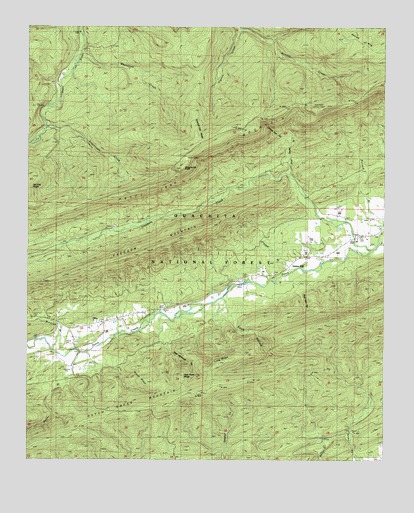
Freedom Mountain, AR USGS Topographic Map
Click on map above to begin viewing in our Map Viewer.

This topographic map contains these locations and features:
Feature Name Type Latitude Longitude GNIS ID View Map
Bear Knob Lookout TowerTowerN34.9768°W93.7735°81966View Map
Beurknob MountainSummitN34.9768°W93.7719°74449View Map
Blue Hole HollowValleyN34.9293°W93.7833°70732View Map
Brush RidgeRidgeN34.8970°W93.8321°70857View Map
Coffee Pot HollowValleyN34.9662°W93.7846°71181View Map
Dutch Creek SchoolSchoolN34.9320°W93.7830°71479View Map
Freedom CreekStreamN34.9362°W93.7549°76973View Map
Freedom Creek CemeteryCemeteryN34.9451°W93.8363°71682View Map
Freedom MountainSummitN34.9398°W93.8188°71683View Map
Haletown Volunteer Fire DepartmentBuildingN34.9146°W93.8484°2116522View Map
High Point RidgeRidgeN34.8995°W93.8202°72010View Map
Hogan MountainSummitN34.9956°W93.7566°72036View Map
Hunt CemeteryCemeteryN34.9404°W93.7521°72117View Map
Kingdoodle CreekStreamN34.9723°W93.8688°72261View Map
Kingdoodle KnobSummitN34.9607°W93.8205°72262View Map
Long RidgeRidgeN34.9040°W93.8055°72484View Map
Mount Moriah ChurchChurchN34.9134°W93.8530°72756View Map
OlioPopulated PlaceN34.9148°W93.8485°72941View Map
Parker BranchStreamN34.9309°W93.7835°72999View Map
Pigeon CreekStreamN34.9990°W93.8008°73069View Map
Rock Quarry BranchStreamN34.9573°W93.7833°73346View Map
Rocky BranchStreamN34.9062°W93.8566°73357View Map
Spanish Oak RidgeRidgeN34.9762°W93.8177°73659View Map
Suck HollowValleyN34.9220°W93.8071°73745View Map
Township of HuntCivilN34.9627°W93.7590°69065View Map
Township of JamesCivilN34.9092°W93.8590°69066View Map
Union HillPopulated PlaceN34.9320°W93.7821°66343View Map
Union Hill ChurchChurchN34.9282°W93.7913°73940View Map
Waldron BranchStreamN34.9070°W93.8663°73983View Map
West Moreland HollowValleyN34.9176°W93.8294°74077View Map
Whetstone CreekStreamN34.9926°W93.8571°74095View Map

Note: Coordinates in the location and feature list above are referenced to NAD83 datum.


Copyright (C) 2008-2024 Ryan Niemi / Sunset Dynamics ... All Rights Reserved