TopoQuest Logo
Do you find TopoQuest useful?
Help keep TopoQuest running and adding new maps/features by donating!
Bitcoin:  19c7KJd3qBynnjoSw5npx9KScwjBe4ifkT
Litecoin:  LXs6TkuXGGXo1vDsWCkWVdjQX94eUKd6ui
Home View Maps Find Maps Find Places Resources & Links


Parrish, Florida Topographic Map

USGS Map Title: Parrish, FL
USGS Map MRC: 27082E4
DRG (GeoTIFF) Download: o27082e4.tif


Neighboring USGS Topographic Map Quads:


  Cockroach Bay, FL  
27082F5
 

  Ruskin, FL  
27082F4
 

  Wimauma, FL  
27082F3
 

  Palmetto, FL  
27082E5
 

  Parrish, FL  
27082E4
 

  Rye, FL  
27082E3
 

  Bradenton, FL  
27082D5
 

  Lorraine, FL  
27082D4
 

  Verna, FL  
27082D3


Map MRC Location:

N28°
W83°
N28°
W82°
H8 H7 H6 H5 H4 H3 H2 H1
G8 G7 G6 G5 G4 G3 G2 G1
F8 F7 F6 F5 F4 F3 F2 F1
E8 E7 E6 E5 E4 E3 E2 E1
D8 D7 D6 D5 D4 D3 D2 D1
C8 C7 C6 C5 C4 C3 C2 C1
B8 B7 B6 B5 B4 B3 B2 B1
A8 A7 A6 A5 A4 A3 A2 A1
N27°
W83°
N27°
W82°

Parrish, FL USGS 1:24K Topographic Map Preview:
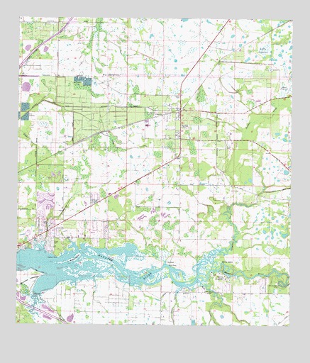
Parrish, FL USGS Topographic Map
Click on map above to begin viewing in our Map Viewer.

This topographic map contains these locations and features:
Feature Name Type Latitude Longitude GNIS ID View Map
Big SawgrassSwampN27.6006°W82.4569°278740View Map
Bliss Fire TowerTowerN27.5936°W82.4259°300007View Map
Branches HammockIslandN27.5186°W82.4979°279327View Map
Buffalo CanalCanalN27.5886°W82.4682°279621View Map
Christian Retreat CampgroundLocaleN27.5192°W82.4045°280423View Map
Cypress StrandStreamN27.5106°W82.4904°281247View Map
Devils ElbowBendN27.5250°W82.4056°281530View Map
Ellenton Post OfficePost OfficeN27.5365°W82.4924°2768141View Map
EriePopulated PlaceN27.5711°W82.4782°300005View Map
Flying Eagle CampLocaleN27.5167°W82.3804°282638View Map
Fort HamerPopulated PlaceN27.5253°W82.4301°295293View Map
Fortner CemeteryCemeteryN27.5729°W82.4046°282716View Map
Gamble CreekStreamN27.5203°W82.4170°282892View Map
Gates CreekStreamN27.5161°W82.4240°282966View Map
Goddard CreekStreamN27.5206°W82.3754°283134View Map
Little SawgrassSwampN27.6136°W82.3877°285812View Map
Marsh IslandIslandN27.5259°W82.4759°286451View Map
Mill CreekStreamN27.5192°W82.4145°286875View Map
Mill Creek ChurchChurchN27.5139°W82.4131°286884View Map
New Hope Baptist ChurchChurchN27.5428°W82.4679°2481727View Map
North River Fire District Station 4BuildingN27.5379°W82.4875°2644572View Map
ParrishPopulated PlaceN27.5875°W82.4251°288540View Map
Parrish Fire DistrictBuildingN27.5715°W82.4262°2131392View Map
Parrish Post OfficePost OfficeN27.5722°W82.4264°2768162View Map
Redfish PointCapeN27.5278°W82.4809°289573View Map
Saint Marys ChurchChurchN27.5856°W82.4334°290302View Map
Vegetable Railroad StationLocaleN27.5836°W82.4429°300006View Map
Wade CanalCanalN27.5720°W82.4520°292814View Map
WDUV-FM (Bradenton)TowerN27.5959°W82.4515°308961View Map

Note: Coordinates in the location and feature list above are referenced to NAD83 datum.


Copyright (C) 2008-2025 Ryan Niemi / Sunset Dynamics ... All Rights Reserved