TopoQuest Logo
Do you find TopoQuest useful?
Help keep TopoQuest running and adding new maps/features by donating!
Bitcoin:  19c7KJd3qBynnjoSw5npx9KScwjBe4ifkT
Litecoin:  LXs6TkuXGGXo1vDsWCkWVdjQX94eUKd6ui
Home View Maps Find Maps Find Places Resources & Links


Ruskin, Florida Topographic Map

USGS Map Title: Ruskin, FL
USGS Map MRC: 27082F4
DRG (GeoTIFF) Download: o27082f4.tif


Neighboring USGS Topographic Map Quads:


  Port Tampa, FL  
27082G5
 

  Gibsonton, FL  
27082G4
 

  Riverview, FL  
27082G3
 

  Cockroach Bay, FL  
27082F5
 

  Ruskin, FL  
27082F4
 

  Wimauma, FL  
27082F3
 

  Palmetto, FL  
27082E5
 

  Parrish, FL  
27082E4
 

  Rye, FL  
27082E3


Map MRC Location:

N28°
W83°
N28°
W82°
H8 H7 H6 H5 H4 H3 H2 H1
G8 G7 G6 G5 G4 G3 G2 G1
F8 F7 F6 F5 F4 F3 F2 F1
E8 E7 E6 E5 E4 E3 E2 E1
D8 D7 D6 D5 D4 D3 D2 D1
C8 C7 C6 C5 C4 C3 C2 C1
B8 B7 B6 B5 B4 B3 B2 B1
A8 A7 A6 A5 A4 A3 A2 A1
N27°
W83°
N27°
W82°

Ruskin, FL USGS 1:24K Topographic Map Preview:
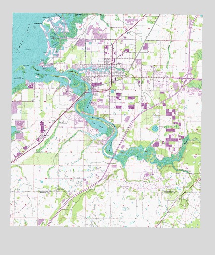
Ruskin, FL USGS Topographic Map
Click on map above to begin viewing in our Map Viewer.

This topographic map contains these locations and features:
Feature Name Type Latitude Longitude GNIS ID View Map
AmandaPopulated PlaceN27.6995°W82.4359°2482185View Map
Andrews CreekStreamN27.6817°W82.4957°277872View Map
Bahia BeachBeachN27.7286°W82.4757°304163View Map
Bahia BeachPopulated PlaceN27.7275°W82.4723°2481495View Map
Bahia Beach HeliportAirportN27.7300°W82.4751°309859View Map
Banana CreekStreamN27.7392°W82.4740°278073View Map
Bayou Pass VillagePopulated PlaceN27.7046°W82.4041°2481539View Map
Bird KeyIslandN27.7214°W82.4840°278813View Map
Blackstone at Bay ParkPopulated PlaceN27.7227°W82.4123°2481630View Map
Bolster BayouBayN27.6720°W82.4348°279194View Map
BraemarPopulated PlaceN27.7392°W82.4333°2481670View Map
Byrd AcresPopulated PlaceN27.6895°W82.3914°2482670View Map
Cabbage CreekStreamN27.7303°W82.4723°279784View Map
Calusa BayPopulated PlaceN27.7075°W82.4830°2482681View Map
Campus ShoresPopulated PlaceN27.7151°W82.4373°2482701View Map
Careys Pirate PointPopulated PlaceN27.7189°W82.4563°2482723View Map
Chalaiman EstatesPopulated PlaceN27.7178°W82.4136°2482804View Map
Chicken IslandIslandN27.7164°W82.4715°280380View Map
College ChasePopulated PlaceN27.7107°W82.4222°2482875View Map
ColluraPopulated PlaceN27.7195°W82.4742°2482883View Map
Covina at Bay ParkPopulated PlaceN27.7225°W82.4223°2482950View Map
Crab CreekStreamN27.7359°W82.4751°280968View Map
Curiosity CreekStreamN27.6670°W82.4295°281158View Map
Cypress Creek VillagePopulated PlaceN27.7325°W82.3763°2482241View Map
Devils ElbowBendN27.7114°W82.4601°281531View Map
DoerrPopulated PlaceN27.7164°W82.4480°2482316View Map
Elizabeth AcresPopulated PlaceN27.6493°W82.3904°2482426View Map
Fairmont Mobile EstatesPopulated PlaceN27.6959°W82.4420°2482483View Map
Fairmont ParkPopulated PlaceN27.7025°W82.4332°2482484View Map
First Baptist Ruskin Christian SchoolSchoolN27.7303°W82.4345°302613View Map
Flamingo PlazaLocaleN27.7128°W82.4454°296055View Map
FlournoyPopulated PlaceN27.6958°W82.3961°2482539View Map
Gaudys ParadisePopulated PlaceN27.6735°W82.4012°2483262View Map
Gilberts Camp SitesLocaleN27.7200°W82.4505°2481996View Map
Goat IslandIslandN27.7134°W82.4668°283131View Map
Green AcresPopulated PlaceN27.7270°W82.4307°2483332View Map
Gulf CityPopulated PlaceN27.7059°W82.4618°283487View Map
Gull HavenPopulated PlaceN27.7162°W82.4531°2483364View Map
HamtonPopulated PlaceN27.6930°W82.4447°2483399View Map
Harbour IslesPopulated PlaceN27.7439°W82.4127°2483415View Map
Hayes BayouBayN27.6848°W82.4429°283834View Map
Hillsborough County Fire Rescue Station 17 RuskinBuildingN27.7135°W82.4287°2131577View Map
Hillsborough County Fire Rescue Station 8 SundanceBuildingN27.6573°W82.3848°2131651View Map
Hillsborough County Sheriff's Office Community Substation RuskinBuildingN27.7211°W82.4476°2333833View Map
Hillsborough County Sheriff's Office District 4BuildingN27.7147°W82.3893°2333591View Map
Hillsborough County Southwest Water Treatment PlantLocaleN27.7197°W82.3843°2482003View Map
Hunter PassChannelN27.7473°W82.4676°284405View Map
Interchange 240CrossingN27.7126°W82.3846°2481864View Map
Kims CovePopulated PlaceN27.7163°W82.4454°2483719View Map
Kings Point Commercial CenterLocaleN27.7110°W82.3777°2482013View Map
LeonPopulated PlaceN27.6938°W82.4258°2483024View Map
Lillie EstatesPopulated PlaceN27.7112°W82.4493°2483035View Map
Little Manatee HeightsPopulated PlaceN27.6895°W82.4381°2483067View Map
Little Manatee RiverStreamN27.7145°W82.4654°285736View Map
Lost River PreservePopulated PlaceN27.6983°W82.4940°2483098View Map
Manatee HarborPopulated PlaceN27.7068°W82.4666°2483162View Map
Mangrove PointCapeN27.7445°W82.4795°286379View Map
MaplewoodPopulated PlaceN27.6868°W82.3791°2483181View Map
MarquettePopulated PlaceN27.6958°W82.3976°2483204View Map
Marsh BranchStreamN27.7189°W82.4334°286449View Map
MaysPopulated PlaceN27.6977°W82.4413°2484214View Map
Mill BayouBayN27.6956°W82.4483°286849View Map
Mill HighlandsPopulated PlaceN27.6954°W82.4445°2484275View Map
Mira Lago WestPopulated PlaceN27.7241°W82.4560°2484288View Map
Montero VillagePopulated PlaceN27.7189°W82.3783°2484310View Map
Myrtle TreePopulated PlaceN27.6918°W82.3870°2484347View Map
Negro IslandIslandN27.7173°W82.4759°287574View Map
NetherlandPopulated PlaceN27.7202°W82.4525°2484366View Map
North Branch ShoresPopulated PlaceN27.7194°W82.4550°2484389View Map
Onstott AcresPopulated PlaceN27.6738°W82.3993°2484502View Map
Park VillagePopulated PlaceN27.6968°W82.4116°2484577View Map
Pelican CoveBayN27.7464°W82.4751°288669View Map
Pelican PointPopulated PlaceN27.7186°W82.4371°2484609View Map
Pirate PointCapeN27.7161°W82.4534°288992View Map
Pirates PointPopulated PlaceN27.7175°W82.4568°2483900View Map
Point HeronPopulated PlaceN27.7185°W82.4454°2483918View Map
River BendPopulated PlaceN27.6930°W82.4321°2484037View Map
River OaksPopulated PlaceN27.7078°W82.4699°2484052View Map
River Shore FarmsPopulated PlaceN27.7081°W82.4828°2484057View Map
RowellPopulated PlaceN27.6715°W82.3946°2484140View Map
Rowell PlacePopulated PlaceN27.6715°W82.3966°2484141View Map
RuskinPopulated PlaceN27.7209°W82.4331°290065View Map
Ruskin Branch Library Hillsborough County Public LibraryBuildingN27.7187°W82.4336°2481271View Map
Ruskin CemeteryCemeteryN27.6884°W82.4356°290066View Map
Ruskin Census Designated PlaceCensusN27.7066°W82.4214°2403499View Map
Ruskin Colony EstatesPopulated PlaceN27.7083°W82.4044°2484154View Map
Ruskin Colony FarmsPopulated PlaceN27.7116°W82.4168°2484155View Map
Ruskin Elementary SchoolSchoolN27.7117°W82.4328°297946View Map
Ruskin Family Drive-InLocaleN27.7367°W82.4272°2651434View Map
Ruskin InletGutN27.7167°W82.4395°290067View Map
Ruskin InletPopulated PlaceN27.7172°W82.4402°2484156View Map
Ruskin Memorial GardensCemeteryN27.6878°W82.4290°298607View Map
Ruskin Post OfficePost OfficeN27.7228°W82.4330°2768224View Map
Sable CovePopulated PlaceN27.7148°W82.4494°2484162View Map
Saffold ParkPopulated PlaceN27.7034°W82.4447°2484164View Map
Sanctuary EstatesPopulated PlaceN27.6568°W82.4094°2484844View Map
Sand IslandIslandN27.7228°W82.4807°290527View Map
Sand KeyIslandN27.7173°W82.4926°290529View Map
Sand PointCapeN27.7198°W82.4926°290546View Map
Sandpiper PointPopulated PlaceN27.7174°W82.4419°2484849View Map
SelnervillePopulated PlaceN27.7077°W82.4756°2484883View Map
Sheron Lee EstatesPopulated PlaceN27.6831°W82.4323°2484938View Map
Shooks FollyPopulated PlaceN27.7029°W82.4011°2484945View Map
Sill ManorPopulated PlaceN27.7087°W82.4330°2484951View Map
Snake IslandIslandN27.7167°W82.4587°291290View Map
SolitudePopulated PlaceN27.6921°W82.4529°2484978View Map
South County Regional Wastewater Treatment PlantLocaleN27.7214°W82.3836°2482067View Map
Spyglass at River BendPopulated PlaceN27.6878°W82.4317°2485028View Map
Sun CityPopulated PlaceN27.6784°W82.4787°291813View Map
Sun City Center PlazaLocaleN27.7231°W82.4323°296054View Map
Sun City Post OfficePost OfficeN27.6752°W82.4812°2768229View Map
Sun SchoolSchoolN27.6867°W82.4657°291818View Map
SundancePopulated PlaceN27.6497°W82.4076°2485101View Map
Sundance Trails Phase 1Populated PlaceN27.6548°W82.3793°2485102View Map
Thea SimmonsPopulated PlaceN27.7231°W82.4263°2485283View Map
Tropical IslandIslandN27.7175°W82.4843°292454View Map
Twin LakePopulated PlaceN27.6975°W82.4452°2485364View Map
Venetian at Bay ParkPopulated PlaceN27.7289°W82.4186°2485412View Map
Wellington North at Bay ParkPopulated PlaceN27.7260°W82.4155°2484651View Map
Wellington South at Bay ParkPopulated PlaceN27.7224°W82.4095°2484652View Map
Whiskey KeyIslandN27.7142°W82.4809°293189View Map
Wildcat CreekStreamN27.6795°W82.4426°293289View Map
Winding CreekPopulated PlaceN27.6687°W82.4530°2484773View Map
Wolf BranchPopulated PlaceN27.7072°W82.4261°2484788View Map

Note: Coordinates in the location and feature list above are referenced to NAD83 datum.


Copyright (C) 2008-2024 Ryan Niemi / Sunset Dynamics ... All Rights Reserved