TopoQuest Logo
Do you find TopoQuest useful?
Help keep TopoQuest running and adding new maps/features by donating!
Bitcoin:  19c7KJd3qBynnjoSw5npx9KScwjBe4ifkT
Litecoin:  LXs6TkuXGGXo1vDsWCkWVdjQX94eUKd6ui
Home View Maps Find Maps Find Places Resources & Links


Parrottsville, Tennessee Topographic Map

USGS Map Title: Parrottsville, TN
USGS Map MRC: 36083A1
DRG (GeoTIFF) Download: o36083a1.tif


Neighboring USGS Topographic Map Quads:


  Springvale, TN  
36083B2
 

  Mohawk, TN  
36083B1
 

  Mosheim, TN  
36082B8
 

  Rankin, TN  
36083A2
 

  Parrottsville, TN  
36083A1
 

  Cedar Creek, TN  
36082A8
 

  Newport, TN  
35083H2
 

  Neddy Mountain, TN  
35083H1
 

  Paint Rock, NC  
35082H8


Map MRC Location:

N37°
W84°
N37°
W83°
H8 H7 H6 H5 H4 H3 H2 H1
G8 G7 G6 G5 G4 G3 G2 G1
F8 F7 F6 F5 F4 F3 F2 F1
E8 E7 E6 E5 E4 E3 E2 E1
D8 D7 D6 D5 D4 D3 D2 D1
C8 C7 C6 C5 C4 C3 C2 C1
B8 B7 B6 B5 B4 B3 B2 B1
A8 A7 A6 A5 A4 A3 A2 A1
N36°
W84°
N36°
W83°

Parrottsville, TN USGS 1:24K Topographic Map Preview:
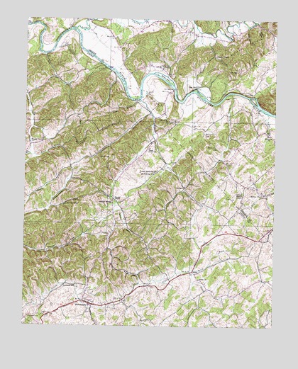
Parrottsville, TN USGS Topographic Map
Click on map above to begin viewing in our Map Viewer.

This topographic map contains these locations and features:
Feature Name Type Latitude Longitude GNIS ID View Map
Barger HollowValleyN36.0174°W83.0665°1326781View Map
Bear CreekStreamN36.1107°W83.1160°1326783View Map
Bear Creek Baptist ChurchChurchN36.1015°W83.1090°1326881View Map
Bewley ChapelChurchN36.1051°W83.0565°1326789View Map
Bewley IslandIslandN36.1009°W83.0554°1326790View Map
Big OvenArchN36.0504°W83.0807°1326839View Map
Bird HillPopulated PlaceN36.1248°W83.1154°1326873View Map
Bower HollowValleyN36.1223°W83.0139°1326792View Map
Brookside MillPopulated PlaceN36.0157°W83.0974°1326793View Map
Browns ShoalsBarN36.0873°W83.0029°1643117View Map
Bruner GrovePopulated PlaceN36.0751°W83.1160°1326794View Map
Bruner Grove United Methodist ChurchChurchN36.0762°W83.1154°1326882View Map
Bruner HollowValleyN36.0469°W83.1135°1647146View Map
Bruners Grove School (historical)SchoolN36.0759°W83.1154°1326883View Map
Buck BranchStreamN36.0698°W83.1224°1326795View Map
Buleys ShoalsBarN36.0982°W83.0524°1643114View Map
Busler BranchStreamN36.0918°W83.0671°1326867View Map
Busler HollowValleyN36.0915°W83.0673°1326796View Map
Byrd Holt HollowValleyN36.0768°W83.1006°1326797View Map
Cobble BranchStreamN36.1240°W83.0702°1326762View Map
Curentons Ferry (historical)LocaleN36.0962°W83.0671°1643047View Map
Dawson Valley School (historical)SchoolN36.0018°W83.1215°1326869View Map
Easterly School (historical)SchoolN36.0729°W83.0582°1326865View Map
Ellison KnobSummitN36.1151°W83.0140°1326810View Map
Evans IslandIslandN36.0920°W83.0110°1326811View Map
Fox HollowValleyN36.0488°W83.1113°1326813View Map
Freshour HollowValleyN36.0084°W83.0372°1647136View Map
Goodwater BranchStreamN36.0868°W83.0627°1326814View Map
Goodwater School (historical)SchoolN36.0809°W83.0724°1326866View Map
Hale BridgeBridgeN36.0968°W83.0507°1326815View Map
Harned ChapelChurchN36.0518°W83.0804°1326816View Map
Harned chapel School (historical)SchoolN36.0520°W83.0810°1326864View Map
Harneds Chapel GraveyardCemeteryN36.0523°W83.0802°1643022View Map
Houston ChapelChurchN36.0501°W83.1040°1326817View Map
Jackson BranchStreamN36.1195°W83.0346°1326818View Map
Jackson ChapelChurchN36.1101°W83.0307°1326819View Map
Johnson BranchStreamN36.1132°W83.1104°1326821View Map
Keesel HollowValleyN36.0594°W83.0800°1647142View Map
Kyker BranchStreamN36.0870°W83.0038°1326824View Map
Little Chucky CreekStreamN36.1212°W83.1013°1326826View Map
Little OvenArchN36.0558°W83.0811°1643049View Map
Love Memorial ChurchChurchN36.0790°W83.0024°1326827View Map
Low GapGapN36.1045°W83.0240°1326828View Map
Luther Memorial ChurchChurchN36.0632°W83.0588°1326829View Map
Lynch HillSummitN36.0695°W83.0835°1326830View Map
Mount Bethany ChurchChurchN36.0620°W83.0604°1326834View Map
Needmore BranchStreamN36.1020°W83.0799°1326840View Map
Nelsons Ferry (historical)CrossingN36.0940°W83.0443°1643115View Map
Nelsons ShoalsBarN36.0915°W83.0474°1643116View Map
North Fork Clear CreekStreamN36.0223°W83.0429°1295872View Map
Norton HollowValleyN36.1222°W83.0075°1326843View Map
Ottering Shelton ChapelChurchN36.0548°W83.0160°1326844View Map
OttingerPopulated PlaceN36.0565°W83.0452°1326845View Map
Ottinger CemeteryCemeteryN36.0037°W83.1227°1326846View Map
Ottinger CreekStreamN36.0554°W83.0449°1326847View Map
Ottinger School (historical)SchoolN36.0459°W83.0399°1326863View Map
Ottinger Shelton ChapelChurchN36.0548°W83.0160°1326885View Map
Oven CreekStreamN36.0923°W83.0679°1326848View Map
Oven Creek ChurchChurchN36.0723°W83.0635°1326849View Map
Palmer HollowValleyN36.0525°W83.1223°1647145View Map
Parrotsville Elementary SchoolSchoolN36.0084°W83.0915°1326870View Map
ParrottsvillePopulated PlaceN36.0093°W83.0924°1326851View Map
Parrottsville Post OfficePost OfficeN36.0086°W83.0913°1649848View Map
Parrottsville United Methodist ChurchChurchN36.0090°W83.0924°1326884View Map
Parrottsville Volunteer Fire DepartmentBuildingN36.0085°W83.0909°2654354View Map
Pate HillPopulated PlaceN36.0973°W83.0404°1326852View Map
Phillips HollowValleyN36.0760°W83.1128°1647144View Map
Poplar Springs School (historical)SchoolN36.0723°W83.0196°1326875View Map
Rader BranchStreamN36.0787°W83.0749°1326854View Map
Reaves Mill (historical)LocaleN36.0962°W83.0418°1326874View Map
SalemPopulated PlaceN36.0220°W83.0407°1326856View Map
Salem ChurchChurchN36.0187°W83.0371°1326858View Map
Salem School (historical)SchoolN36.0193°W83.0363°1643028View Map
Scsruggs ShoalsBarN36.1207°W83.1010°1643113View Map
Shelton BranchStreamN36.0537°W83.0032°1326763View Map
Shelton ChapelChurchN36.0537°W83.0049°1326764View Map
Sinking CreekStreamN36.0923°W83.0679°1326765View Map
Slate CreekStreamN36.0937°W83.0254°1326766View Map
South Fork Clear CreekStreamN36.0220°W83.0427°1326767View Map
Stillhouse BranchStreamN36.1054°W83.0846°1326768View Map
Stullz BranchStreamN36.1243°W83.0529°1326769View Map
The KnobsRidgeN36.0432°W83.0271°1326862View Map
Tobey HollowValleyN36.0831°W83.0779°1647143View Map
Town of ParrottsvilleCivilN36.0082°W83.0913°2407078View Map
Trantham HollowValleyN36.0470°W83.0757°1326771View Map
Union Hill Church (historical)ChurchN36.0387°W83.0535°1326871View Map
Warrensburg Airport (historical)AirportN36.1182°W83.0957°1326860View Map
Zion Hill School (historical)SchoolN36.0634°W83.1046°1326868View Map

Note: Coordinates in the location and feature list above are referenced to NAD83 datum.


Copyright (C) 2008-2024 Ryan Niemi / Sunset Dynamics ... All Rights Reserved