TopoQuest Logo
Do you find TopoQuest useful?
Help keep TopoQuest running and adding new maps/features by donating!
Bitcoin:  19c7KJd3qBynnjoSw5npx9KScwjBe4ifkT
Litecoin:  LXs6TkuXGGXo1vDsWCkWVdjQX94eUKd6ui
Home View Maps Find Maps Find Places Resources & Links


Pass a Loutre West, Louisiana Topographic Map

USGS Map Title: Pass a Loutre West, LA
USGS Map MRC: 29089B2
DRG (GeoTIFF) Download: o29089b2.tif


Neighboring USGS Topographic Map Quads:


  Venice, LA  
29089C3


  Pilottown, LA  
29089B3
 

  Pass a Loutre West, LA  
29089B2


  Dixon Bay, LA  
29089A3


Map MRC Location:

N30°
W90°
N30°
W89°
H8 H7 H6 H5 H4 H3 H2 H1
G8 G7 G6 G5 G4 G3 G2 G1
F8 F7 F6 F5 F4 F3 F2 F1
E8 E7 E6 E5 E4 E3 E2 E1
D8 D7 D6 D5 D4 D3 D2 D1
C8 C7 C6 C5 C4 C3 C2 C1
B8 B7 B6 B5 B4 B3 B2 B1
A8 A7 A6 A5 A4 A3 A2 A1
N29°
W90°
N29°
W89°

Pass a Loutre West, LA USGS 1:24K Topographic Map Preview:
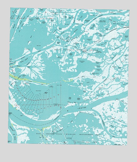
Pass a Loutre West, LA USGS Topographic Map
Click on map above to begin viewing in our Map Viewer.

This topographic map contains these locations and features:
Feature Name Type Latitude Longitude GNIS ID View Map
Adolph Clark PassBayN29.1649°W89.1744°1629544View Map
Adolph Clarks Pond (historical)BayN29.1905°W89.1737°1629555View Map
Adolph PondGutN29.2391°W89.2062°532090View Map
Alberts PondBayN29.1957°W89.2292°542207View Map
Bastian LakeBayN29.1715°W89.1554°532330View Map
Bay RondoBayN29.1874°W89.1834°542433View Map
Bennie PondBayN29.1997°W89.2186°542434View Map
Big PondBayN29.2158°W89.2201°533100View Map
Bluewing PondBayN29.2158°W89.1377°533243View Map
Bottle BayouChannelN29.1708°W89.2167°542438View Map
Bottle Bayou PondBayN29.1804°W89.2285°533341View Map
Brant BayouBayN29.1968°W89.2392°553770View Map
Brant IslandIslandN29.2016°W89.2345°533371View Map
Bruquiere PassGutN29.2247°W89.1373°533448View Map
Buoy PassBayN29.2364°W89.1763°533547View Map
Buoy PondBayN29.2434°W89.1747°533548View Map
Camps PondBayN29.2322°W89.1481°533673View Map
Cane PondBayN29.2418°W89.1869°533715View Map
Charlie Marshall PassChannelN29.1722°W89.1906°542442View Map
Cheniere PassBayN29.1264°W89.1628°533899View Map
Club PondBayN29.2123°W89.2307°534008View Map
Coule PondBayN29.1930°W89.2197°542445View Map
Dave Inside PondBayN29.2054°W89.2013°534396View Map
Dave Outside PondBayN29.2086°W89.1853°534397View Map
Dead Man BayouChannelN29.1933°W89.1706°542447View Map
Dead Women BendBayN29.2372°W89.1364°534431View Map
Dead Women Inside PondBayN29.2344°W89.1634°534432View Map
Dead Women Outside PondBayN29.2391°W89.1531°534433View Map
Dead Women PassBayN29.2468°W89.1381°534434View Map
Deadman PondBayN29.2011°W89.1575°554203View Map
Death PondBayN29.2230°W89.2274°542448View Map
Delta Duck Club (historical)LocaleN29.2072°W89.2345°542449View Map
Delta Duck Oil FieldOilfieldN29.2477°W89.1995°534493View Map
Delta National Wildlife RefugeParkN29.2371°W89.2047°534496View Map
Dymond PondLakeN29.2495°W89.1833°534677View Map
Flatboat Inside PondBayN29.2111°W89.1714°534998View Map
Flatboat Outside PondBayN29.2111°W89.1562°534999View Map
Flatboat PassBayN29.2156°W89.1938°535000View Map
Fleur PondBayN29.2263°W89.1583°535004View Map
French Duck PondBayN29.1913°W89.2135°542450View Map
Goat BayouGutN29.2213°W89.2281°535254View Map
Gondle PondBayN29.1826°W89.1692°1629557View Map
Goose IslandIslandN29.2258°W89.1859°535284View Map
Goose Island Inside PassBayN29.2225°W89.1938°535287View Map
Goose Island Outside PondBayN29.2297°W89.1801°542451View Map
Harrys PondBayN29.1316°W89.1963°535545View Map
Hingle BendBayN29.2021°W89.1322°535678View Map
Hingle PondBayN29.1969°W89.1345°535680View Map
Horse Duck PondBayN29.2247°W89.2337°542452View Map
Horseshoe PondBayN29.2005°W89.1733°554783View Map
Jackass BayBayN29.1374°W89.1318°535979View Map
Japan IslandIslandN29.2491°W89.1303°536003View Map
Japan PassBayN29.2469°W89.1595°536005View Map
Joe Brown PassBayN29.1832°W89.2361°1629558View Map
Joe Brown PondBayN29.1944°W89.1562°536057View Map
Joe Dennis PondBayN29.2183°W89.1520°536059View Map
John Johnson BayouChannelN29.2302°W89.2334°542454View Map
John Johnson PassGutN29.2349°W89.2359°536071View Map
John Johnson PondBayN29.2364°W89.2384°536072View Map
Kitchen PondBayN29.2040°W89.2137°542455View Map
L'Homme PondBayN29.1657°W89.2102°536236View Map
Lake PondBayN29.1738°W89.1891°536293View Map
Little Lake PondBayN29.1783°W89.2059°536573View Map
Little Twentyseven PondBayN29.2174°W89.1795°555105View Map
Lucien PondBayN29.1995°W89.2151°542456View Map
Mack PondBayN29.1744°W89.1706°555206View Map
Major Inside PondBayN29.2344°W89.2220°542457View Map
Major Outside PondBayN29.2372°W89.2148°536859View Map
Mann Inside PondBayN29.1677°W89.1859°536878View Map
Mann Outside PondBayN29.1674°W89.1767°536879View Map
Marion PassChannelN29.2183°W89.2120°542458View Map
Martins PassChannelN29.1752°W89.2259°542459View Map
Maziers PondBayN29.1652°W89.2273°542460View Map
Minout PondBayN29.2163°W89.2401°542461View Map
Morgan PondBayN29.1885°W89.2342°537209View Map
Nicholl PondBayN29.2064°W89.1404°537673View Map
Nom Inside PondBayN29.2208°W89.1574°537697View Map
Nom Outside PondBayN29.2263°W89.1523°537698View Map
Noms PassBayN29.2190°W89.1598°537699View Map
Octave PassBayN29.2136°W89.2108°555535View Map
Octave PondBayN29.2311°W89.1969°537815View Map
Paddy BayBayN29.1809°W89.1421°537934View Map
Pailleen Queue PondBayN29.1908°W89.1606°537938View Map
Parry O'Neill ReefBarN29.2080°W89.1306°542472View Map
Pass a LoutreBayN29.1609°W89.1723°537994View Map
Paul Morgan Ridge (historical)RidgeN29.1891°W89.2239°542473View Map
Paul PondBayN29.2304°W89.2021°538024View Map
Petit Felix PondBayN29.2397°W89.2276°538091View Map
Pintail PondBayN29.1924°W89.2050°542475View Map
Post PondBayN29.2346°W89.1960°538360View Map
Raphael PassBayN29.1821°W89.1535°538494View Map
Raphael Pass Gas FieldOilfieldN29.2294°W89.1339°558697View Map
Rigaud Ridge (historical)RidgeN29.1961°W89.2201°542477View Map
Robinson PondBayN29.1974°W89.1564°538654View Map
Robinson Reef (historical)BarN29.2058°W89.1939°542478View Map
Round PondBayN29.1741°W89.2187°538750View Map
Sabot PondBayN29.2500°W89.2162°538773View Map
Seagull PondBayN29.2457°W89.2317°539237View Map
Son PondBayN29.2458°W89.1659°539473View Map
Spanish IslandIslandN29.2188°W89.2012°539538View Map
Sprigtail PondBayN29.2408°W89.2214°539557View Map
Swanson BayouBayN29.1568°W89.1257°539752View Map
Tilitie PondBayN29.2418°W89.1922°1629552View Map
Twentyseven PassBayN29.2285°W89.1653°540064View Map
Twentyseven PondBayN29.2229°W89.1690°556288View Map
Washington PondBayN29.2400°W89.1668°540245View Map
Willow PondBayN29.1924°W89.1386°540470View Map
Woodyard Canal (historical)CanalN29.1613°W89.1912°542490View Map
Woodyard PondBayN29.1616°W89.2003°540537View Map

Note: Coordinates in the location and feature list above are referenced to NAD83 datum.


Copyright (C) 2008-2025 Ryan Niemi / Sunset Dynamics ... All Rights Reserved