TopoQuest Logo
Do you find TopoQuest useful?
Help keep TopoQuest running and adding new maps/features by donating!
Bitcoin:  19c7KJd3qBynnjoSw5npx9KScwjBe4ifkT
Litecoin:  LXs6TkuXGGXo1vDsWCkWVdjQX94eUKd6ui
Home View Maps Find Maps Find Places Resources & Links


Berlin, Missouri Topographic Map

USGS Map Title: Berlin, MO
USGS Map MRC: 40094A3
DRG (GeoTIFF) Download: o40094a3.tif


Neighboring USGS Topographic Map Quads:


  Darlington, MO  
40094B4
 

  Albany South, MO  
40094B3
 

  Matkins, MO  
40094B2
 

  Ford City, MO  
40094A4
 

  Berlin, MO  
40094A3
 

  Pattonsburg, MO  
40094A2
 

  Wood, MO  
39094H4
 

  Maysville, MO  
39094H3
 

  Weatherby, MO  
39094H2


Map MRC Location:

N41°
W95°
N41°
W94°
H8 H7 H6 H5 H4 H3 H2 H1
G8 G7 G6 G5 G4 G3 G2 G1
F8 F7 F6 F5 F4 F3 F2 F1
E8 E7 E6 E5 E4 E3 E2 E1
D8 D7 D6 D5 D4 D3 D2 D1
C8 C7 C6 C5 C4 C3 C2 C1
B8 B7 B6 B5 B4 B3 B2 B1
A8 A7 A6 A5 A4 A3 A2 A1
N40°
W95°
N40°
W94°

Berlin, MO USGS 1:24K Topographic Map Preview:
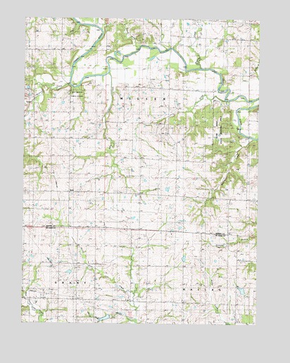
Berlin, MO USGS Topographic Map
Click on map above to begin viewing in our Map Viewer.

This topographic map contains these locations and features:
Feature Name Type Latitude Longitude GNIS ID View Map
Andy Denton Public AccessLocaleN40.0936°W94.3475°741734View Map
Beach BranchStreamN40.1136°W94.3161°713762View Map
BerlinPopulated PlaceN40.0536°W94.3511°713985View Map
Berlin CemeteryCemeteryN40.0467°W94.3502°713986View Map
Brushy CreekStreamN40.1047°W94.2808°714903View Map
Campbell CreekStreamN40.1094°W94.3213°715309View Map
Concord School (historical)SchoolN40.1114°W94.3719°716184View Map
Crawford BridgeBridgeN40.1122°W94.2972°755041View Map
Elam Bend State Wildlife AreaParkN40.0867°W94.2683°737954View Map
Elsworth SchoolSchoolN40.0225°W94.2980°730095View Map
Grandview School (historical)SchoolN40.0681°W94.3186°718688View Map
Grindstone-Lost-Muddy Creek Watershed Dam D-22DamN40.0233°W94.2936°762780View Map
Grindstone-Lost-Muddy Creek Watershed Dam D-23DamN40.0017°W94.3286°762613View Map
Hickory CreekStreamN40.0986°W94.3511°719449View Map
Jestes LakeReservoirN40.0110°W94.3222°761915View Map
Jestes Lake DamDamN40.0117°W94.3202°761914View Map
Jolly CreekStreamN40.0919°W94.2680°720395View Map
Lake Mar-LouReservoirN40.0140°W94.2581°760710View Map
Limestone School (historical)SchoolN40.0200°W94.2608°729535View Map
Nance DamDamN40.0133°W94.2586°760709View Map
Oak Grove School (historical)SchoolN40.0186°W94.3350°729587View Map
Osborne Bridge (historical)BridgeN40.0975°W94.2675°755353View Map
Rattlesnake School (historical)SchoolN40.1189°W94.3202°730186View Map
Red Star School (historical)SchoolN40.0172°W94.3744°729622View Map
Township of MillerCivilN40.1022°W94.3292°766670View Map
Wheeler CreekStreamN40.0761°W94.2533°728691View Map

Note: Coordinates in the location and feature list above are referenced to NAD83 datum.


Copyright (C) 2008-2025 Ryan Niemi / Sunset Dynamics ... All Rights Reserved