TopoQuest Logo
Do you find TopoQuest useful?
Help keep TopoQuest running and adding new maps/features by donating!
Bitcoin:  19c7KJd3qBynnjoSw5npx9KScwjBe4ifkT
Litecoin:  LXs6TkuXGGXo1vDsWCkWVdjQX94eUKd6ui
Home View Maps Find Maps Find Places Resources & Links


Darlington, Missouri Topographic Map

USGS Map Title: Darlington, MO
USGS Map MRC: 40094B4
DRG (GeoTIFF) Download: o40094b4.tif


Neighboring USGS Topographic Map Quads:


  Alanthus Grove, MO  
40094C5
 

  Gentry, MO  
40094C4
 

  Albany North, MO  
40094C3
 

  Stanberry, MO  
40094B5
 

  Darlington, MO  
40094B4
 

  Albany South, MO  
40094B3
 

  King City, MO  
40094A5
 

  Ford City, MO  
40094A4
 

  Berlin, MO  
40094A3


Map MRC Location:

N41°
W95°
N41°
W94°
H8 H7 H6 H5 H4 H3 H2 H1
G8 G7 G6 G5 G4 G3 G2 G1
F8 F7 F6 F5 F4 F3 F2 F1
E8 E7 E6 E5 E4 E3 E2 E1
D8 D7 D6 D5 D4 D3 D2 D1
C8 C7 C6 C5 C4 C3 C2 C1
B8 B7 B6 B5 B4 B3 B2 B1
A8 A7 A6 A5 A4 A3 A2 A1
N40°
W95°
N40°
W94°

Darlington, MO USGS 1:24K Topographic Map Preview:
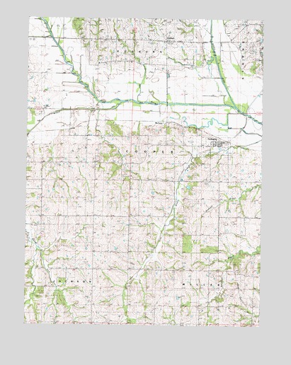
Darlington, MO USGS Topographic Map
Click on map above to begin viewing in our Map Viewer.

This topographic map contains these locations and features:
Feature Name Type Latitude Longitude GNIS ID View Map
Buckley School (historical)SchoolN40.1481°W94.4738°714985View Map
CarmackPopulated PlaceN40.2408°W94.4261°715401View Map
Carmack School (historical)SchoolN40.2397°W94.4275°747019View Map
DarlingtonPopulated PlaceN40.1983°W94.3961°716673View Map
Darlington Post OfficePost OfficeN40.1995°W94.3974°2782745View Map
Davis Lake DamDamN40.2417°W94.3752°762580View Map
East Sager SchoolSchoolN40.1917°W94.4591°717341View Map
Ettieville LakeReservoirN40.1814°W94.4139°762583View Map
Gentry CountyCivilN40.2121°W94.4099°758492View Map
Half CemeteryCemeteryN40.2425°W94.4711°718995View Map
Hall CemeteryCemeteryN40.2425°W94.4719°741719View Map
Hammond Lake DamDamN40.1817°W94.4136°762582View Map
Howell School (historical)SchoolN40.2442°W94.3822°719933View Map
Lindley Lake DamDamN40.1483°W94.4652°762579View Map
Long Branch CemeteryCemeteryN40.1881°W94.4492°2556810View Map
Long Branch ChurchChurchN40.1864°W94.4450°721532View Map
McCurryPopulated PlaceN40.2075°W94.4255°741051View Map
McGuire School (historical)SchoolN40.2405°W94.4527°722124View Map
Middle Fork Grand RiverStreamN40.2142°W94.3886°459036View Map
Mount Zion ChurchChurchN40.1917°W94.4869°722972View Map
Rice Lake (historical)LakeN40.2292°W94.3886°725248View Map
Rodes CemeteryCemeteryN40.2336°W94.3758°725528View Map
Rouse CemeteryCemeteryN40.2030°W94.4094°725630View Map
Saint Patrick CemeteryCemeteryN40.1480°W94.4613°725854View Map
Sloan CemeteryCemeteryN40.1839°W94.3852°726555View Map
Thomas Lake DamDamN40.2383°W94.3886°762581View Map
Township of CooperCivilN40.2087°W94.4995°766666View Map
Village of DarlingtonCivilN40.1980°W94.3997°2398684View Map
Walker School (historical)SchoolN40.1472°W94.4161°728267View Map
West Sager SchoolSchoolN40.1830°W94.4891°728621View Map
Wildcat CreekStreamN40.2156°W94.4497°728836View Map

Note: Coordinates in the location and feature list above are referenced to NAD83 datum.


Copyright (C) 2008-2024 Ryan Niemi / Sunset Dynamics ... All Rights Reserved