TopoQuest Logo
Do you find TopoQuest useful?
Help keep TopoQuest running and adding new maps/features by donating!
Bitcoin:  19c7KJd3qBynnjoSw5npx9KScwjBe4ifkT
Litecoin:  LXs6TkuXGGXo1vDsWCkWVdjQX94eUKd6ui
Home View Maps Find Maps Find Places Resources & Links


Pasture Canyon, New Mexico Topographic Map

USGS Map Title: Pasture Canyon, NM
USGS Map MRC: 34107D7
DRG (GeoTIFF) Download: o34107d7.tif


Neighboring USGS Topographic Map Quads:


  Bonine Canyon, NM  
34107E8
 

  Wild Horse Canyon, NM  
34107E7
 

  Wiley Mesa, NM  
34107E6
 

  Third Canyon, NM  
34107D8
 

  Pasture Canyon, NM  
34107D7
 

  D Cross Mountain, NM  
34107D6
 

  Madre Mountain, NM  
34107C8
 

  Cal Ship Mesa, NM  
34107C7
 

  Dog Springs, NM  
34107C6


Map MRC Location:

N35°
W108°
N35°
W107°
H8 H7 H6 H5 H4 H3 H2 H1
G8 G7 G6 G5 G4 G3 G2 G1
F8 F7 F6 F5 F4 F3 F2 F1
E8 E7 E6 E5 E4 E3 E2 E1
D8 D7 D6 D5 D4 D3 D2 D1
C8 C7 C6 C5 C4 C3 C2 C1
B8 B7 B6 B5 B4 B3 B2 B1
A8 A7 A6 A5 A4 A3 A2 A1
N34°
W108°
N34°
W107°

Pasture Canyon, NM USGS 1:24K Topographic Map Preview:
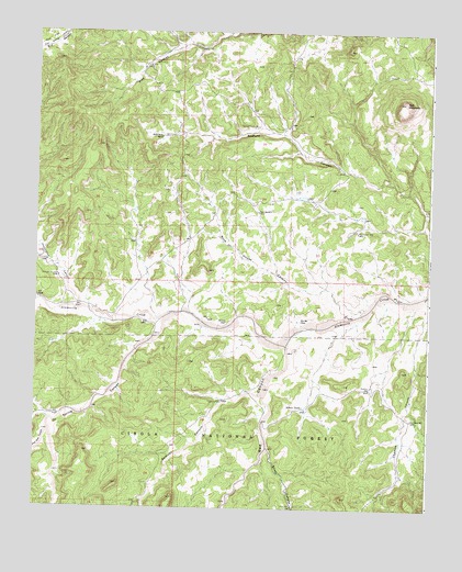
Pasture Canyon, NM USGS Topographic Map
Click on map above to begin viewing in our Map Viewer.

This topographic map contains these locations and features:
Feature Name Type Latitude Longitude GNIS ID View Map
Alkali TankReservoirN34.4018°W107.7900°903095View Map
Bell MountainSummitN34.4817°W107.7587°903733View Map
Blue Mesa WellWellN34.3984°W107.7559°903951View Map
Box Bar PlaceLocaleN34.4242°W107.7912°904032View Map
Buds WindmillLocaleN34.4528°W107.8051°904159View Map
Canyon WellWellN34.3992°W107.8673°904742View Map
Chamisa CanyonValleyN34.4298°W107.7509°905018View Map
Chamisa WellWellN34.4064°W107.7689°905021View Map
Chriswell WindmillLocaleN34.4353°W107.8676°905134View Map
Cow FlatFlatN34.4978°W107.8720°905449View Map
Grapevine CabinLocaleN34.4034°W107.8159°906696View Map
Harrington CanyonValleyN34.4276°W107.8595°906849View Map
McCord PlaceLocaleN34.4239°W107.8148°908499View Map
Ox Spring CanyonValleyN34.4245°W107.8339°909411View Map
Pasture Canyon WellWellN34.4753°W107.8051°909492View Map
Red CanyonValleyN34.4187°W107.7956°910046View Map
Red Feather WellWellN34.4476°W107.7734°910054View Map
Remuda CanyonValleyN34.4051°W107.8037°910119View Map
Rock House CanyonValleyN34.4276°W107.7701°910370View Map
Stiver CanyonValleyN34.3909°W107.8012°911424View Map
Stiver WellWellN34.3756°W107.7931°911426View Map
Upper Pine WellWellN34.4912°W107.8414°912003View Map
White Deer CanyonValleyN34.3951°W107.8706°912294View Map
White House RanchLocaleN34.4726°W107.8356°912301View Map

Note: Coordinates in the location and feature list above are referenced to NAD83 datum.


Copyright (C) 2008-2025 Ryan Niemi / Sunset Dynamics ... All Rights Reserved