TopoQuest Logo
Do you find TopoQuest useful?
Help keep TopoQuest running and adding new maps/features by donating!
Bitcoin:  19c7KJd3qBynnjoSw5npx9KScwjBe4ifkT
Litecoin:  LXs6TkuXGGXo1vDsWCkWVdjQX94eUKd6ui
Home View Maps Find Maps Find Places Resources & Links


Wiley Mesa, New Mexico Topographic Map

USGS Map Title: Wiley Mesa, NM
USGS Map MRC: 34107E6
DRG (GeoTIFF) Download: o34107e6.tif


Neighboring USGS Topographic Map Quads:


  Cebollita Peak, NM  
34107F7
 

  Mecate Meadow, NM  
34107F6
 

  Broom Mountain, NM  
34107F5
 

  Wild Horse Canyon, NM  
34107E7
 

  Wiley Mesa, NM  
34107E6
 

  Pueblo Viejo Mesa, NM  
34107E5
 

  Pasture Canyon, NM  
34107D7
 

  D Cross Mountain, NM  
34107D6
 

  Table Mountain, NM  
34107D5


Map MRC Location:

N35°
W108°
N35°
W107°
H8 H7 H6 H5 H4 H3 H2 H1
G8 G7 G6 G5 G4 G3 G2 G1
F8 F7 F6 F5 F4 F3 F2 F1
E8 E7 E6 E5 E4 E3 E2 E1
D8 D7 D6 D5 D4 D3 D2 D1
C8 C7 C6 C5 C4 C3 C2 C1
B8 B7 B6 B5 B4 B3 B2 B1
A8 A7 A6 A5 A4 A3 A2 A1
N34°
W108°
N34°
W107°

Wiley Mesa, NM USGS 1:24K Topographic Map Preview:
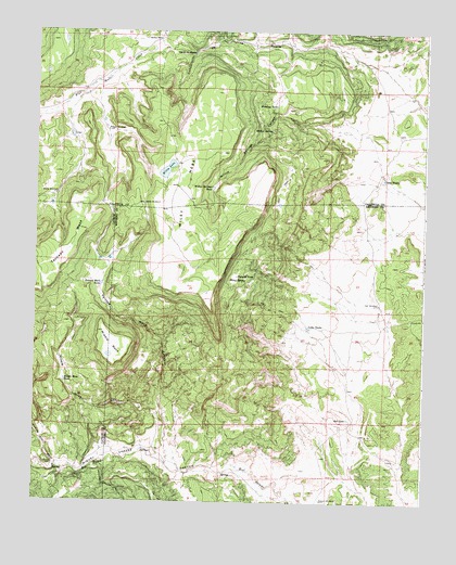
Wiley Mesa, NM USGS Topographic Map
Click on map above to begin viewing in our Map Viewer.

This topographic map contains these locations and features:
Feature Name Type Latitude Longitude GNIS ID View Map
Barela Water WellWellN34.6231°W107.7112°918473View Map
Barela WellWellN34.6228°W107.7109°886065View Map
Carr WindmillLocaleN34.5528°W107.6395°887217View Map
Gist TanksReservoirN34.5856°W107.6387°889420View Map
Karr Windmill Water WellWellN34.5523°W107.6403°925566View Map
Kicking Bear WashStreamN34.5095°W107.7426°890684View Map
La Mosca Water WellWellN34.6209°W107.6548°918716View Map
Latta TanksReservoirN34.5467°W107.6623°890978View Map
Manning CabinLocaleN34.5098°W107.7437°891575View Map
Middle MesaSummitN34.5451°W107.7295°891959View Map
Middle Mesa CanyonValleyN34.5214°W107.7078°891961View Map
Middle Mesa TankReservoirN34.5321°W107.7405°891962View Map
Ojo de la MoscaSpringN34.6193°W107.7000°898081View Map
Painted Rock CanyonValleyN34.5098°W107.7073°893025View Map
Painted Rock TankReservoirN34.5579°W107.7287°893026View Map
Red LakeLakeN34.5224°W107.6494°893757View Map
Rincon Water WellWellN34.5987°W107.7276°918537View Map
Rincon WindmillLocaleN34.5984°W107.7273°893958View Map
S O B Water WellWellN34.6106°W107.6314°918552View Map
Saddle WindmillLocaleN34.5792°W107.7156°894255View Map
Saddle WM Water WellWellN34.5795°W107.7156°918549View Map
Tadpole TankReservoirN34.5601°W107.6855°895485View Map
Watson WindmillLocaleN34.5009°W107.6575°896288View Map
Watson Windmill Water WellWellN34.5009°W107.6581°925817View Map
Wedding TankReservoirN34.6055°W107.6734°902388View Map
Wiley LakeLakeN34.5883°W107.7082°896610View Map
Wiley MesaSummitN34.5623°W107.7039°899995View Map
Wiley SpringSpringN34.5591°W107.6877°896611View Map
Willow SpringSpringN34.5989°W107.6748°896663View Map
Willow Springs CanyonValleyN34.5976°W107.6442°896667View Map
Willow Springs TankReservoirN34.5835°W107.6935°896668View Map
Wylie SpringSpringN34.5539°W107.6845°924438View Map

Note: Coordinates in the location and feature list above are referenced to NAD83 datum.


Copyright (C) 2008-2025 Ryan Niemi / Sunset Dynamics ... All Rights Reserved