TopoQuest Logo
Do you find TopoQuest useful?
Help keep TopoQuest running and adding new maps/features by donating!
Bitcoin:  19c7KJd3qBynnjoSw5npx9KScwjBe4ifkT
Litecoin:  LXs6TkuXGGXo1vDsWCkWVdjQX94eUKd6ui
Home View Maps Find Maps Find Places Resources & Links


Paterson, Washington Topographic Map

USGS Map Title: Paterson, WA
USGS Map MRC: 45119H5
DRG (GeoTIFF) Download: o45119h5.tif


Neighboring USGS Topographic Map Quads:


  Lenzie Ranch, WA  
46119A6
 

  Whitstran SE, WA  
46119A5
 

  Prior Ranch, WA  
46119A4
 

  West of Paterson, WA  
45119H6
 

  Paterson, WA  
45119H5
 

  Irrigon, OR  
45119H4
 

  Boardman, OR  
45119G6
 

  Clarke, OR  
45119G5
 

  Ordnance, OR  
45119G4


Map MRC Location:

N46°
W120°
N46°
W119°
H8 H7 H6 H5 H4 H3 H2 H1
G8 G7 G6 G5 G4 G3 G2 G1
F8 F7 F6 F5 F4 F3 F2 F1
E8 E7 E6 E5 E4 E3 E2 E1
D8 D7 D6 D5 D4 D3 D2 D1
C8 C7 C6 C5 C4 C3 C2 C1
B8 B7 B6 B5 B4 B3 B2 B1
A8 A7 A6 A5 A4 A3 A2 A1
N45°
W120°
N45°
W119°

Paterson, WA USGS 1:24K Topographic Map Preview:
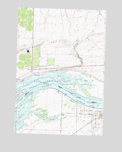
Paterson, WA USGS Topographic Map
Click on map above to begin viewing in our Map Viewer.

This topographic map contains these locations and features:
Feature Name Type Latitude Longitude GNIS ID View Map
Benton County Fire District 6BuildingN45.9402°W119.6015°2643404View Map
Big Blalock IslandIslandN45.9146°W119.6192°1533518View Map
Blalock Island (historical)IslandN45.9146°W119.6192°1533508View Map
Columbia Crest Winery AirportAirportN45.9560°W119.6210°1533883View Map
Cooks Island (historical)IslandN45.9240°W119.5920°1534559View Map
Irrigon Cemetery (historical)CemeteryN45.9015°W119.5017°1122284View Map
Irrigon Fish HatcheryParkN45.9101°W119.5470°2765579View Map
Irrigon Lower RangeChannelN45.9124°W119.5414°1156775View Map
Island Number 17 (historical)IslandN45.9068°W119.5134°1639289View Map
Island Number 18 (historical)IslandN45.9118°W119.5359°1639290View Map
John Day Wildlife Management AreaParkN45.8824°W119.5692°1122451View Map
John Day Wildlife Management AreaParkN45.9343°W119.5109°1505827View Map
Judson (historical)LocaleN45.8935°W119.5703°1167781View Map
Long Walk IslandIslandN45.9010°W119.6180°2765077View Map
Long Walk IslandIslandN45.9015°W119.6164°1156774View Map
McCormack SloughLakeN45.8934°W119.5909°1129781View Map
Monument IslandIslandN45.9260°W119.6067°1509706View Map
Number 18 Island (historical)IslandN45.9118°W119.5359°1534560View Map
PatersonPopulated PlaceN45.9371°W119.6028°1511216View Map
Paterson Elementary SchoolSchoolN45.9354°W119.5922°1515541View Map
Paterson Elementary SchoolSchoolN45.9386°W119.6091°1533422View Map
Paterson JunctionLocaleN45.8960°W119.5584°1125218View Map
Paterson Post OfficePost OfficeN45.9401°W119.6028°2781669View Map
Paterson RidgeRidgeN45.9579°W119.6156°1513290View Map
Patterson Ferry Boat RampLocaleN45.9141°W119.5547°2700187View Map
Umatilla National Wildlife RefugeParkN45.8988°W119.5928°1133437View Map

Note: Coordinates in the location and feature list above are referenced to NAD83 datum.


Copyright (C) 2008-2025 Ryan Niemi / Sunset Dynamics ... All Rights Reserved