TopoQuest Logo
Do you find TopoQuest useful?
Help keep TopoQuest running and adding new maps/features by donating!
Bitcoin:  19c7KJd3qBynnjoSw5npx9KScwjBe4ifkT
Litecoin:  LXs6TkuXGGXo1vDsWCkWVdjQX94eUKd6ui
Home View Maps Find Maps Find Places Resources & Links


Boardman, Oregon Topographic Map

USGS Map Title: Boardman, OR
USGS Map MRC: 45119G6
DRG (GeoTIFF) Download: o45119g6.tif


Neighboring USGS Topographic Map Quads:


  Canoe Ridge, WA  
45119H7
 

  West of Paterson, WA  
45119H6
 

  Paterson, WA  
45119H5
 

  Crow Butte, WA  
45119G7
 

  Boardman, OR  
45119G6
 

  Clarke, OR  
45119G5
 

  Ella, OR  
45119F7
 

  Well Spring, OR  
45119F6
 

  Strawberry Canyon NE, OR  
45119F5


Map MRC Location:

N46°
W120°
N46°
W119°
H8 H7 H6 H5 H4 H3 H2 H1
G8 G7 G6 G5 G4 G3 G2 G1
F8 F7 F6 F5 F4 F3 F2 F1
E8 E7 E6 E5 E4 E3 E2 E1
D8 D7 D6 D5 D4 D3 D2 D1
C8 C7 C6 C5 C4 C3 C2 C1
B8 B7 B6 B5 B4 B3 B2 B1
A8 A7 A6 A5 A4 A3 A2 A1
N45°
W120°
N45°
W119°

Boardman, OR USGS 1:24K Topographic Map Preview:
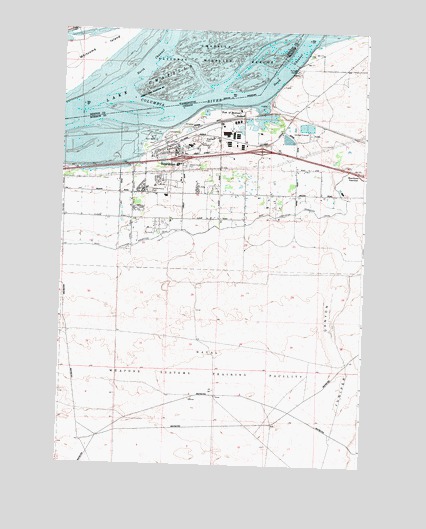
Boardman, OR USGS Topographic Map
Click on map above to begin viewing in our Map Viewer.

This topographic map contains these locations and features:
Feature Name Type Latitude Longitude GNIS ID View Map
BoardmanPopulated PlaceN45.8399°W119.7006°1136082View Map
Boardman CemeteryCemeteryN45.8435°W119.6922°1157392View Map
Boardman City HallBuildingN45.8325°W119.7036°2700409View Map
Boardman City Police DepartmentBuildingN45.8325°W119.7036°2737853View Map
Boardman DivisionCivilN45.7637°W119.7478°1937967View Map
Boardman Marina ParkParkN45.8440°W119.7097°1129779View Map
Boardman Marina Park Boat RampLocaleN45.8426°W119.7127°2698977View Map
Boardman Post OfficePost OfficeN45.8400°W119.7034°1164933View Map
Boardman Public Works DepartmentBuildingN45.8473°W119.6948°2700408View Map
Boardman Rural Fire Protection District Station 1BuildingN45.8282°W119.7060°2576637View Map
Boardman Wastewater Treatment PlantLocaleN45.8474°W119.6511°2697192View Map
Boardman Water Treatment PlantLocaleN45.8473°W119.6948°2697193View Map
City of BoardmanCivilN45.8372°W119.6957°2409873View Map
CoyoteLocaleN45.8549°W119.6664°1135868View Map
Coyote (historical)LocaleN45.8560°W119.6639°1167734View Map
Coyote Island (historical)IslandN45.8679°W119.6636°1161649View Map
Coyote Islands (historical)IslandN45.8651°W119.6628°1509967View Map
Coyote Post Office (historical)Post OfficeN45.8549°W119.6664°1165098View Map
Coyote SpringSpringN45.8374°W119.6520°1132084View Map
Coyote Springs Cogeneration ProjectLocaleN45.8480°W119.6738°2699267View Map
Faler Road Treaty Fishing Access SiteReserveN45.8404°W119.7150°2434179View Map
Juniper CanyonValleyN45.8096°W119.6317°1122573View Map
Messinger Lower RangeChannelN45.8499°W119.7123°1156771View Map
Messinger Middle RangeChannelN45.8568°W119.6706°1156772View Map
Messinger Upper RangeChannelN45.8624°W119.6567°1156773View Map
Messner (historical)LocaleN45.8493°W119.6800°1124077View Map
Messner MarshSwampN45.8326°W119.6725°1129780View Map
Morrow County Health District Boardman StationBuildingN45.8282°W119.7066°2553794View Map
Oregon Trail Library District Boardman LibraryBuildingN45.8359°W119.7014°2700451View Map
Peters (historical)LocaleN45.8440°W119.7411°1167804View Map
Port of Morrow HarborHarborN45.8525°W119.6681°1129778View Map
Riverside Junior and Senior High SchoolSchoolN45.8417°W119.6977°1161874View Map
Riverview CemeteryCemeteryN45.8434°W119.6923°1126057View Map
Sam Boardman Elementary SchoolSchoolN45.8274°W119.7074°1161875View Map
Whitcomb IslandIslandN45.8721°W119.7345°1533531View Map
Windy River Elementary SchoolSchoolN45.8272°W119.7040°2486627View Map

Note: Coordinates in the location and feature list above are referenced to NAD83 datum.


Copyright (C) 2008-2024 Ryan Niemi / Sunset Dynamics ... All Rights Reserved