TopoQuest Logo
Do you find TopoQuest useful?
Help keep TopoQuest running and adding new maps/features by donating!
Bitcoin:  19c7KJd3qBynnjoSw5npx9KScwjBe4ifkT
Litecoin:  LXs6TkuXGGXo1vDsWCkWVdjQX94eUKd6ui
Home View Maps Find Maps Find Places Resources & Links


Pawnee, Oklahoma Topographic Map

USGS Map Title: Pawnee, OK
USGS Map MRC: 36096C7
DRG (GeoTIFF) Download: o36096c7.tif


Neighboring USGS Topographic Map Quads:


  Watchorn, OK  
36096D8
 

  Masham, OK  
36096D7
 

  Skedee, OK  
36096D6
 

  Lela, OK  
36096C8
 

  Pawnee, OK  
36096C7
 

  Casey, OK  
36096C6
 

  Glencoe, OK  
36096B8
 

  West Point, OK  
36096B7
 

  Maramec, OK  
36096B6


Map MRC Location:

N37°
W97°
N37°
W96°
H8 H7 H6 H5 H4 H3 H2 H1
G8 G7 G6 G5 G4 G3 G2 G1
F8 F7 F6 F5 F4 F3 F2 F1
E8 E7 E6 E5 E4 E3 E2 E1
D8 D7 D6 D5 D4 D3 D2 D1
C8 C7 C6 C5 C4 C3 C2 C1
B8 B7 B6 B5 B4 B3 B2 B1
A8 A7 A6 A5 A4 A3 A2 A1
N36°
W97°
N36°
W96°

Pawnee, OK USGS 1:24K Topographic Map Preview:
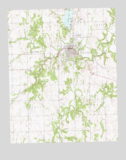
Pawnee, OK USGS Topographic Map
Click on map above to begin viewing in our Map Viewer.

This topographic map contains these locations and features:
Feature Name Type Latitude Longitude GNIS ID View Map
Antioch Baptist ChurchChurchN36.3339°W96.7992°1809779View Map
Christian Church DisciplesChurchN36.3362°W96.8036°1809780View Map
City of PawneeCivilN36.3364°W96.8019°2411389View Map
First Baptist ChurchChurchN36.3342°W96.8036°1809781View Map
Highland CemeteryCemeteryN36.3631°W96.7932°1093754View Map
Little Skedee CreekStreamN36.3737°W96.8003°1094844View Map
Lower Black Bear Creek Site 1 DamDamN36.3617°W96.7520°1754717View Map
Lower Black Bear Creek Site 1 ReservoirReservoirN36.3623°W96.7517°1754718View Map
Lower Black Bear Creek Site 16 DamDamN36.3017°W96.8470°1754707View Map
Lower Black Bear Creek Site 16 ReservoirReservoirN36.3015°W96.8475°1754708View Map
Lower Black Bear Creek Site 18 DamDamN36.2701°W96.8236°1754705View Map
Lower Black Bear Creek Site 18 ReservoirReservoirN36.2701°W96.8236°1754706View Map
Lower Black Bear Creek Site 21 DamDamN36.2551°W96.8153°1754703View Map
Lower Black Bear Creek Site 21 ReservoirReservoirN36.2532°W96.8146°1754704View Map
Lower Black Bear Creek Site 23 DamDamN36.2917°W96.7670°1754701View Map
Lower Black Bear Creek Site 23 ReservoirReservoirN36.2917°W96.7670°1754702View Map
Lower Black Bear Creek Site 5 DamDamN36.3517°W96.8486°1754711View Map
Lower Black Bear Creek Site 5 ReservoirReservoirN36.3534°W96.8484°1754712View Map
Lower Black Bear Number 17 DamDamN36.3301°W96.8120°1751975View Map
Lower Black Bear Number 17 ReservoirReservoirN36.3303°W96.8128°1751976View Map
North Indian CemeteryCemeteryN36.3649°W96.7921°1095971View Map
Old Town Trading PostLocaleN36.3189°W96.8536°1096253View Map
PawneePopulated PlaceN36.3378°W96.8039°1096479View Map
Pawnee Bill Museum State ParkParkN36.3253°W96.8134°1096480View Map
Pawnee City DamDamN36.3584°W96.8020°1751880View Map
Pawnee City LakeReservoirN36.3584°W96.8020°1751881View Map
Pawnee County JailBuildingN36.3385°W96.8030°2757861View Map
Pawnee County Sheriff's OfficeBuildingN36.3385°W96.8029°2757695View Map
Pawnee DivisionCivilN36.3547°W96.7935°1937823View Map
Pawnee Elementary SchoolSchoolN36.3361°W96.8052°1819275View Map
Pawnee Fire and RescueBuildingN36.3394°W96.8026°2657502View Map
Pawnee Health CenterHospitalN36.3355°W96.7866°2695816View Map
Pawnee High SchoolSchoolN36.3329°W96.8055°1819274View Map
Pawnee LakeReservoirN36.3656°W96.8052°1096482View Map
Pawnee Middle SchoolSchoolN36.3330°W96.8049°1790430View Map
Pawnee Municipal Hospital HeliportAirportN36.3334°W96.8006°1102630View Map
Pawnee Nation Police DepartmentBuildingN36.3378°W96.7915°2757880View Map
Pawnee Police StationBuildingN36.3394°W96.8027°2757628View Map
Pepper CreekStreamN36.3306°W96.8334°1096549View Map
Peters CreekStreamN36.3573°W96.8745°1096573View Map
Skedee CreekStreamN36.3434°W96.8009°1098088View Map
South Indian CemeteryCemeteryN36.2903°W96.8170°1098257View Map
Township of BurnhamCivilN36.2806°W96.7725°1824841View Map
Township of LibertyCivilN36.2862°W96.8586°1824840View Map

Note: Coordinates in the location and feature list above are referenced to NAD83 datum.


Copyright (C) 2008-2025 Ryan Niemi / Sunset Dynamics ... All Rights Reserved