TopoQuest Logo
Do you find TopoQuest useful?
Help keep TopoQuest running and adding new maps/features by donating!
Bitcoin:  19c7KJd3qBynnjoSw5npx9KScwjBe4ifkT
Litecoin:  LXs6TkuXGGXo1vDsWCkWVdjQX94eUKd6ui
Home View Maps Find Maps Find Places Resources & Links


Peanut Mountain, Arkansas Topographic Map

USGS Map Title: Peanut Mountain, AR
USGS Map MRC: 34094G2
DRG (GeoTIFF) Download: o34094g2.tif


Neighboring USGS Topographic Map Quads:


  Cauthron, AR  
34094H3
 

  Hon, AR  
34094H2
 

  Waldron, AR  
34094H1
 

  Horseshoe Mountain, AR  
34094G3
 

  Peanut Mountain, AR  
34094G2
 

  Boles, AR  
34094G1
 

  Rich Mountain, AR  
34094F3
 

  Acorn, AR  
34094F2
 

  Y City, AR  
34094F1


Map MRC Location:

N35°
W95°
N35°
W94°
H8 H7 H6 H5 H4 H3 H2 H1
G8 G7 G6 G5 G4 G3 G2 G1
F8 F7 F6 F5 F4 F3 F2 F1
E8 E7 E6 E5 E4 E3 E2 E1
D8 D7 D6 D5 D4 D3 D2 D1
C8 C7 C6 C5 C4 C3 C2 C1
B8 B7 B6 B5 B4 B3 B2 B1
A8 A7 A6 A5 A4 A3 A2 A1
N34°
W95°
N34°
W94°

Peanut Mountain, AR USGS 1:24K Topographic Map Preview:
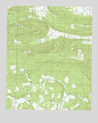
Peanut Mountain, AR USGS Topographic Map
Click on map above to begin viewing in our Map Viewer.

This topographic map contains these locations and features:
Feature Name Type Latitude Longitude GNIS ID View Map
Black ForkStreamN34.7679°W94.1588°76360View Map
BlansettPopulated PlaceN34.7901°W94.2202°70717View Map
Blansett School (historical)SchoolN34.7898°W94.2194°66266View Map
Brushy HollowValleyN34.8543°W94.2391°70868View Map
Brushy MountainRidgeN34.8376°W94.2333°70872View Map
Bruton RidgeRidgeN34.8134°W94.1333°70882View Map
Clear ForkStreamN34.7679°W94.1588°76629View Map
DentonPopulated PlaceN34.8368°W94.1910°66283View Map
Denton CreekStreamN34.8493°W94.1852°71369View Map
Denton SchoolSchoolN34.8373°W94.1908°71370View Map
Dogwood FlatsFlatN34.8626°W94.2449°71404View Map
Giles Lake DamDamN34.8701°W94.1385°80562View Map
Giles PondReservoirN34.8709°W94.1366°80563View Map
Heath CreekStreamN34.7587°W94.2147°71954View Map
Henry BranchStreamN34.7870°W94.1769°71965View Map
Henry MountainRidgeN34.8187°W94.2266°77163View Map
NellaPopulated PlaceN34.7604°W94.1635°77801View Map
Nella Volunteer Fire DepartmentBuildingN34.7609°W94.1936°2116842View Map
Oliver BranchStreamN34.7770°W94.2049°72943View Map
Peanut MountainSummitN34.8082°W94.1869°73028View Map
Piney CreekStreamN34.8723°W94.1949°73108View Map
Poteau River Site 14 LakeReservoirN34.8534°W94.2369°80571View Map
Poteau River Site 17 LakeReservoirN34.8636°W94.1816°80543View Map
Poteau River Site 18 LakeReservoirN34.8329°W94.1326°81127View Map
Poteau River Watershed Site 14 DamDamN34.8534°W94.2369°80570View Map
Poteau River Watershed Site 17 DamDamN34.8634°W94.1835°80542View Map
Poteau River Watershed Site 18 DamDamN34.8351°W94.1335°81126View Map
Ray BranchStreamN34.7884°W94.1888°73245View Map
RitzPopulated PlaceN34.7532°W94.2363°73306View Map
Robson SchoolSchoolN34.7579°W94.2341°73324View Map
Rowdy MountainSummitN34.8204°W94.1530°73425View Map
ShilohPopulated PlaceN34.7607°W94.1780°66334View Map
Shiloh CemeteryCemeteryN34.7609°W94.1827°66335View Map
Shiloh Missionary Baptist ChurchChurchN34.7607°W94.1833°66336View Map
Shiloh SchoolSchoolN34.7601°W94.1824°73548View Map
Township of BlansettCivilN34.7672°W94.2412°69057View Map
Township of DentonCivilN34.8702°W94.1869°69062View Map
Vestal BranchStreamN34.7662°W94.1330°73967View Map
Whisenhunt CemeteryCemeteryN34.7832°W94.1980°74097View Map

Note: Coordinates in the location and feature list above are referenced to NAD83 datum.


Copyright (C) 2008-2024 Ryan Niemi / Sunset Dynamics ... All Rights Reserved