TopoQuest Logo
Do you find TopoQuest useful?
Help keep TopoQuest running and adding new maps/features by donating!
Bitcoin:  19c7KJd3qBynnjoSw5npx9KScwjBe4ifkT
Litecoin:  LXs6TkuXGGXo1vDsWCkWVdjQX94eUKd6ui
Home View Maps Find Maps Find Places Resources & Links


Pecks Pond, Pennsylvania Topographic Map

USGS Map Title: Pecks Pond, PA
USGS Map MRC: 41075C1
DRG (GeoTIFF) Download: o41075c1.tif


Neighboring USGS Topographic Map Quads:


  Hawley, PA  
41075D2
 

  Rowland, PA  
41075D1
 

  Shohola, PA  
41074D8
 

  Promised Land, PA  
41075C2
 

  Pecks Pond, PA  
41075C1
 

  Edgemere, PA  
41074C8
 

  Skytop, PA  
41075B2
 

  Twelvemile Pond, PA  
41075B1
 

  Lake Maskenozha, PA  
41074B8


Map MRC Location:

N42°
W76°
N42°
W75°
H8 H7 H6 H5 H4 H3 H2 H1
G8 G7 G6 G5 G4 G3 G2 G1
F8 F7 F6 F5 F4 F3 F2 F1
E8 E7 E6 E5 E4 E3 E2 E1
D8 D7 D6 D5 D4 D3 D2 D1
C8 C7 C6 C5 C4 C3 C2 C1
B8 B7 B6 B5 B4 B3 B2 B1
A8 A7 A6 A5 A4 A3 A2 A1
N41°
W76°
N41°
W75°

Pecks Pond, PA USGS 1:24K Topographic Map Preview:
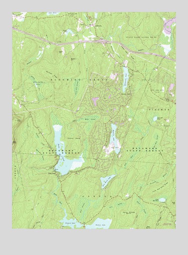
Pecks Pond, PA USGS Topographic Map
Click on map above to begin viewing in our Map Viewer.

This topographic map contains these locations and features:
Feature Name Type Latitude Longitude GNIS ID View Map
Ben Bush SwampSwampN41.2998°W75.0153°1169219View Map
Billings CreekStreamN41.3615°W75.0630°1169623View Map
Birchy CreekStreamN41.3523°W75.0049°1169654View Map
Blooming Grove Fire Department Main StationBuildingN41.3699°W75.0640°2653555View Map
Blue Heron LakeReservoirN41.2780°W75.0528°1169876View Map
Burleigh RidgeRidgeN41.3379°W75.0924°1170723View Map
Camp Biff TrailTrailN41.2954°W75.1146°1205708View Map
Dingman SpringSpringN41.3248°W75.0043°1173288View Map
Dorys DamDamN41.2734°W75.0563°1195429View Map
Elbow SwampSwampN41.2620°W75.0255°1174076View Map
Elm LakeReservoirN41.3240°W75.0614°1195475View Map
Fivemile MeadowAreaN41.2781°W75.0124°1174875View Map
Flat Ridge TrailTrailN41.2551°W75.0110°1205707View Map
Hemlock FarmsPopulated PlaceN41.3268°W75.0366°1176801View Map
Hemlock Farms Census Designated PlaceCensusN41.3157°W75.0515°2633371View Map
Hemlock Farms Volunteer Fire and Rescue CompanyBuildingN41.3123°W75.0564°2653087View Map
Hemlock LakeReservoirN41.3039°W75.0472°1176810View Map
Hemlock Lake DamDamN41.2968°W75.0463°1195455View Map
Hemlock Pond DamDamN41.2968°W75.0460°1208848View Map
High KnobSummitN41.2998°W75.1246°1177008View Map
High Knob Fire TowerTowerN41.2995°W75.1249°1212939View Map
Holsey Meadow SwampSwampN41.3320°W75.1054°1177234View Map
Holsey RunStreamN41.3393°W75.1157°1177235View Map
Indian Cabin RidgeRidgeN41.3501°W75.0349°1177733View Map
Inlet SwampSwampN41.2641°W75.0428°1177817View Map
Kinney TrailTrailN41.2876°W75.1030°1205772View Map
Lavice Meadow BarrenFlatN41.2598°W75.0363°1179043View Map
Ledgeway PondLakeN41.3176°W75.0518°2786814View Map
Little Mud PondLakeN41.2668°W75.0105°1179613View Map
Little Mud Pond RidgeRidgeN41.2737°W75.0116°1179615View Map
Little York SwampSwampN41.3317°W75.0755°1179719View Map
Lords ValleyPopulated PlaceN41.3676°W75.0624°1179950View Map
Low KnobSummitN41.3126°W75.1213°1179998View Map
Lower Hemlock DamDamN41.2934°W75.0446°1195446View Map
Lower Hemlock LakeReservoirN41.2951°W75.0443°1195447View Map
Madden HillSummitN41.3479°W75.0802°1180171View Map
Maley HillSummitN41.3520°W75.0891°1180240View Map
Maple CreekStreamN41.3095°W75.0863°1180317View Map
Maple SwampSwampN41.3135°W75.0653°1180370View Map
McConnell CreekStreamN41.3609°W75.0482°1180650View Map
McConnell Lake DamDamN41.3437°W75.0382°1208841View Map
Mcconnell Lake DamDamN41.3434°W75.0379°1195488View Map
McConnell PondReservoirN41.3368°W75.0382°1180652View Map
Mount RunStreamN41.3540°W75.0963°1181844View Map
Pecks PondPopulated PlaceN41.2831°W75.0921°1183437View Map
Pecks PondReservoirN41.2923°W75.0859°1183438View Map
Pecks Pond DamDamN41.2818°W75.0880°1195436View Map
Pecks Pond Picnic AreaAreaN41.2829°W75.0805°1205773View Map
Pecks Pond Post Office (historical)Post OfficeN41.2831°W75.0921°2027102View Map
Persons PondLakeN41.3635°W75.0805°1183613View Map
Pickeral Pond DamDamN41.2518°W75.0863°1195407View Map
Pickerel LakeReservoirN41.2538°W75.0800°1193115View Map
Pierson DamDamN41.3629°W75.0752°1208855View Map
Pike CountyCivilN41.3320°W75.0338°1213683View Map
Pinchot IslandIslandN41.3006°W75.0777°1183754View Map
Porters LakeReservoirN41.2518°W75.0590°1193157View Map
Porters Lake DamDamN41.2501°W75.0696°1195404View Map
Rock HillSummitN41.2539°W75.0736°1185253View Map
Rock Hill CampLocaleN41.3093°W75.0079°1185254View Map
Rock Hill CreekStreamN41.2537°W75.0730°1201884View Map
Rock Hill PondLakeN41.3136°W75.0156°1185258View Map
Smith TrailTrailN41.2834°W75.1080°1205706View Map
State Game Lands Number 180ParkN41.3623°W75.0268°1199985View Map
Tarkill CreekStreamN41.2987°W75.0921°1189281View Map
Tarkill Demonstration AreaAreaN41.3034°W75.1063°1201563View Map
Township of Blooming GroveCivilN41.3583°W75.0989°1216957View Map
Westbrook Estate DamDamN41.3718°W75.1163°1208860View Map
White Birch SwampSwampN41.2905°W75.1016°1191249View Map
Wolf SwampSwampN41.2629°W75.0710°1191690View Map
York CreekStreamN41.3601°W75.0674°1191896View Map

Note: Coordinates in the location and feature list above are referenced to NAD83 datum.


Copyright (C) 2008-2024 Ryan Niemi / Sunset Dynamics ... All Rights Reserved