TopoQuest Logo
Do you find TopoQuest useful?
Help keep TopoQuest running and adding new maps/features by donating!
Bitcoin:  19c7KJd3qBynnjoSw5npx9KScwjBe4ifkT
Litecoin:  LXs6TkuXGGXo1vDsWCkWVdjQX94eUKd6ui
Home View Maps Find Maps Find Places Resources & Links


Pennington, Georgia Topographic Map

USGS Map Title: Pennington, GA
USGS Map MRC: 32084B1
DRG (GeoTIFF) Download: o32084b1.tif


Neighboring USGS Topographic Map Quads:


  Ideal South, GA  
32084C2
 

  Montezuma, GA  
32084C1
 

  Marshallville SW, GA  
32083C8
 

  Andersonville, GA  
32084B2
 

  Pennington, GA  
32084B1
 

  Byromville, GA  
32083B8
 

  Americus, GA  
32084A2
 

  Methvins, GA  
32084A1
 

  Drayton, GA  
32083A8


Map MRC Location:

N33°
W85°
N33°
W84°
H8 H7 H6 H5 H4 H3 H2 H1
G8 G7 G6 G5 G4 G3 G2 G1
F8 F7 F6 F5 F4 F3 F2 F1
E8 E7 E6 E5 E4 E3 E2 E1
D8 D7 D6 D5 D4 D3 D2 D1
C8 C7 C6 C5 C4 C3 C2 C1
B8 B7 B6 B5 B4 B3 B2 B1
A8 A7 A6 A5 A4 A3 A2 A1
N32°
W85°
N32°
W84°

Pennington, GA USGS 1:24K Topographic Map Preview:
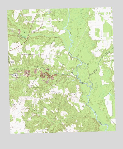
Pennington, GA USGS Topographic Map
Click on map above to begin viewing in our Map Viewer.

This topographic map contains these locations and features:
Feature Name Type Latitude Longitude GNIS ID View Map
Boggy BranchStreamN32.2265°W84.1210°346940View Map
Camp CreekStreamN32.2110°W84.0532°312222View Map
Chamblis MillLocaleN32.1366°W84.0649°355104View Map
ClearviewPopulated PlaceN32.2477°W84.0744°326220View Map
Goose CreekStreamN32.2463°W84.0555°314698View Map
Hodges CemeteryCemeteryN32.1546°W84.1188°315486View Map
Hogcrawl CreekStreamN32.1713°W84.0280°315521View Map
Kelley CemeteryCemeteryN32.1788°W84.0557°316349View Map
Mount Springs ChurchChurchN32.2046°W84.0866°318884View Map
Mountain CreekStreamN32.1418°W84.0291°319059View Map
Mountain Creek ChurchChurchN32.1379°W84.0718°319068View Map
Norris CemeteryCemeteryN32.2007°W84.0688°319628View Map
PenningtonPopulated PlaceN32.1602°W84.0871°326463View Map
Pennyton School (historical)SchoolN32.1666°W84.0907°343479View Map
Prison BranchStreamN32.1913°W84.1249°321150View Map
Russell Thomas LakeReservoirN32.1774°W84.0480°338052View Map
Russell Thomas Lake DamDamN32.1785°W84.0466°338051View Map
Saint James-Pennington CemeteryCemeteryN32.1710°W84.0966°322096View Map
Saint Johns CemeteryCemeteryN32.2204°W84.0682°346982View Map
Saint Johns ChurchChurchN32.2207°W84.0685°322120View Map
Sweetwater CreekStreamN32.1827°W84.0441°323836View Map
Tolen CemeteryCemeteryN32.2177°W84.0696°324210View Map
Triple CreekStreamN32.2257°W84.1041°324323View Map
Walker BranchStreamN32.2365°W84.0591°324763View Map
Zion TempleChurchN32.2404°W84.0857°346991View Map

Note: Coordinates in the location and feature list above are referenced to NAD83 datum.


Copyright (C) 2008-2025 Ryan Niemi / Sunset Dynamics ... All Rights Reserved