TopoQuest Logo
Do you find TopoQuest useful?
Help keep TopoQuest running and adding new maps/features by donating!
Bitcoin:  19c7KJd3qBynnjoSw5npx9KScwjBe4ifkT
Litecoin:  LXs6TkuXGGXo1vDsWCkWVdjQX94eUKd6ui
Home View Maps Find Maps Find Places Resources & Links


Drayton, Georgia Topographic Map

USGS Map Title: Drayton, GA
USGS Map MRC: 32083A8
DRG (GeoTIFF) Download: o32083a8.tif


Neighboring USGS Topographic Map Quads:


  Pennington, GA  
32084B1
 

  Byromville, GA  
32083B8
 

  Pinehurst, GA  
32083B7
 

  Methvins, GA  
32084A1
 

  Drayton, GA  
32083A8
 

  Vienna, GA  
32083A7
 

  Leslie, GA  
31084H1
 

  Cobb, GA  
31083H8
 

  Cordele, GA  
31083H7


Map MRC Location:

N33°
W84°
N33°
W83°
H8 H7 H6 H5 H4 H3 H2 H1
G8 G7 G6 G5 G4 G3 G2 G1
F8 F7 F6 F5 F4 F3 F2 F1
E8 E7 E6 E5 E4 E3 E2 E1
D8 D7 D6 D5 D4 D3 D2 D1
C8 C7 C6 C5 C4 C3 C2 C1
B8 B7 B6 B5 B4 B3 B2 B1
A8 A7 A6 A5 A4 A3 A2 A1
N32°
W84°
N32°
W83°

Drayton, GA USGS 1:24K Topographic Map Preview:
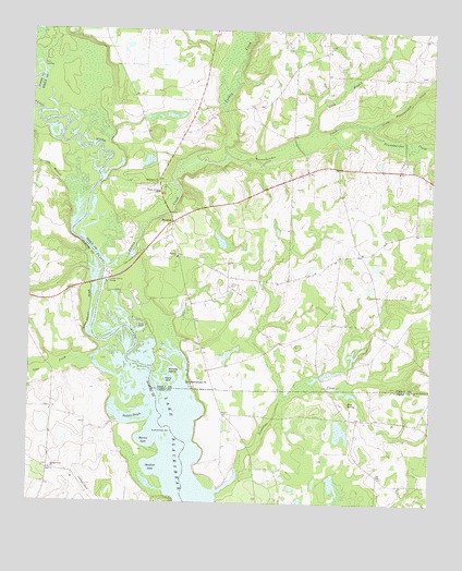
Drayton, GA USGS Topographic Map
Click on map above to begin viewing in our Map Viewer.

This topographic map contains these locations and features:
Feature Name Type Latitude Longitude GNIS ID View Map
Barren LakeLakeN32.0166°W83.9632°310824View Map
Bethel Church (historical)ChurchN32.0763°W83.8888°335194View Map
Blue SpringSpringN32.0268°W83.9002°311555View Map
Collier CemeteryCemeteryN32.0579°W83.9374°312843View Map
Collier SpringSpringN32.0560°W83.9477°335197View Map
Danville (historical)Populated PlaceN32.0563°W83.9874°343432View Map
Danville BluffCliffN32.0696°W83.9849°1705057View Map
Dooly County Fire Department Drayton StationBuildingN32.0709°W83.9560°2604327View Map
DraytonPopulated PlaceN32.0741°W83.9555°331587View Map
Drayton Baptist ChurchChurchN32.0654°W83.9541°355549View Map
Drayton Methodist ChurchChurchN32.0724°W83.9560°335207View Map
Franklin School (historical)SchoolN32.0638°W83.9074°335217View Map
Gleaton-Johnson SloughStreamN32.0518°W83.9802°314636View Map
Glory HoleBayN32.0321°W83.9549°314648View Map
Gum PondLakeN32.0474°W83.9646°314974View Map
Holland ParkLakeN32.1027°W83.9582°335222View Map
Lake SawdustLakeN32.0082°W83.9610°322602View Map
Lilly BranchStreamN32.0960°W83.9138°316861View Map
Lime CreekStreamN32.0382°W83.9813°316867View Map
Limestone CreekStreamN32.0304°W83.9010°316881View Map
Limestone CreekStreamN32.0091°W83.9343°316887View Map
Little Pennahatchee CreekStreamN32.0999°W83.8946°317145View Map
Luther Storey BridgeBridgeN32.0588°W83.9768°317493View Map
Macedonia CemeteryCemeteryN32.0843°W83.9618°335230View Map
Macedonia Methodist ChurchChurchN32.0843°W83.9605°317539View Map
Morgan Grove School (historical)SchoolN32.0577°W83.9457°335235View Map
Murray BranchStreamN32.0838°W83.9896°319166View Map
Murrys Ferry (historical)CrossingN32.0607°W83.9768°343473View Map
Parkers SloughGutN32.0232°W83.9671°320233View Map
Pennahatchee CreekStreamN32.0924°W83.9385°320363View Map
Shady Grove ChurchChurchN32.0824°W83.9599°322750View Map
Smokehouse PointCapeN32.0318°W83.9505°323170View Map
Spring Creek ChurchChurchN32.0088°W83.9927°323394View Map
Springhill CemeteryCemeteryN32.0004°W83.9224°323475View Map
Taylor Lake Dam NorthDamN32.0835°W83.9982°341672View Map
Taylor Lake NorthReservoirN32.0840°W83.9981°341673View Map
Turkey CreekStreamN32.0643°W83.9768°324376View Map
Whisky IslandIslandN32.0341°W83.9538°325132View Map

Note: Coordinates in the location and feature list above are referenced to NAD83 datum.


Copyright (C) 2008-2025 Ryan Niemi / Sunset Dynamics ... All Rights Reserved