TopoQuest Logo
Do you find TopoQuest useful?
Help keep TopoQuest running and adding new maps/features by donating!
Bitcoin:  19c7KJd3qBynnjoSw5npx9KScwjBe4ifkT
Litecoin:  LXs6TkuXGGXo1vDsWCkWVdjQX94eUKd6ui
Home View Maps Find Maps Find Places Resources & Links


Pepin, Wisconsin Topographic Map

USGS Map Title: Pepin, WI
USGS Map MRC: 44092D2
DRG (GeoTIFF) Download: o44092d2.tif


Neighboring USGS Topographic Map Quads:


  Maiden Rock, WI  
44092E3
 

  Nerike Hill, WI  
44092E2
 

  Ella, WI  
44092E1
 

  Lake City, MN  
44092D3
 

  Pepin, WI  
44092D2
 

  Wabasha North, MN  
44092D1
 

  West Albany, MN  
44092C3
 

  Theilman, MN  
44092C2
 

  Wabasha South, MN  
44092C1


Map MRC Location:

N45°
W93°
N45°
W92°
H8 H7 H6 H5 H4 H3 H2 H1
G8 G7 G6 G5 G4 G3 G2 G1
F8 F7 F6 F5 F4 F3 F2 F1
E8 E7 E6 E5 E4 E3 E2 E1
D8 D7 D6 D5 D4 D3 D2 D1
C8 C7 C6 C5 C4 C3 C2 C1
B8 B7 B6 B5 B4 B3 B2 B1
A8 A7 A6 A5 A4 A3 A2 A1
N44°
W93°
N44°
W92°

Pepin, WI USGS 1:24K Topographic Map Preview:
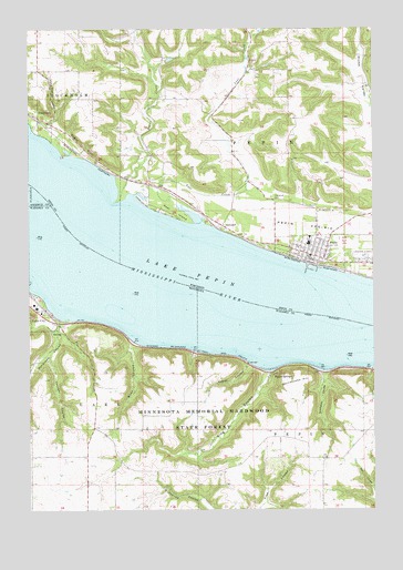
Pepin, WI USGS Topographic Map
Click on map above to begin viewing in our Map Viewer.

This topographic map contains these locations and features:
Feature Name Type Latitude Longitude GNIS ID View Map
2 ReservoirReservoirN44.4918°W92.1988°1792377View Map
Bogus BluffCliffN44.4694°W92.2296°1562011View Map
Bogus CreekStreamN44.4547°W92.2193°1562012View Map
Bogus Creek 1 D-9133 DamDamN44.4916°W92.2002°1792376View Map
Deer IslandIslandN44.4536°W92.2018°1563831View Map
Deer LakeLakeN44.4527°W92.1921°2761264View Map
Dutchman CouleeValleyN44.4106°W92.1436°642998View Map
Handshaw CouleeValleyN44.4234°W92.2368°644622View Map
Horse Thief CouleeValleyN44.4764°W92.2411°1566714View Map
Kepler CouleeValleyN44.4128°W92.1712°646113View Map
King CouleeValleyN44.4105°W92.1631°646156View Map
Lake PepinLakeN44.4333°W92.1752°649273View Map
LakeportPopulated PlaceN44.4486°W92.1799°1577688View Map
Lost CreekStreamN44.4494°W92.1871°1568646View Map
Lost Creek 3 D-31.10 DamDamN44.4900°W92.1635°1792373View Map
Lost Creek 4 D 31.10 DamDamN44.4983°W92.1668°1792374View Map
Lost Creek 5 D 31.10 DamDamN44.4916°W92.1702°1792375View Map
Maple SpringsPopulated PlaceN44.4097°W92.1618°654818View Map
Miller CreekStreamN44.4347°W92.2493°647866View Map
Oakwood CemeteryCemeteryN44.4564°W92.1629°1570723View Map
PepinPopulated PlaceN44.4411°W92.1479°1571190View Map
Pepin CountyCivilN44.4827°W92.1497°1581106View Map
Pepin Elementary SchoolSchoolN44.4444°W92.1486°2715783View Map
Pepin Emergency Ambulance ServiceBuildingN44.4455°W92.1411°2698372View Map
Pepin Fire DepartmentBuildingN44.4455°W92.1411°2697748View Map
Pepin High SchoolSchoolN44.4443°W92.1486°1840882View Map
Pepin Police DepartmentBuildingN44.4404°W92.1485°2759532View Map
Pepin PrairieFlatN44.4489°W92.1505°1571192View Map
Rattlesnake HillSummitN44.4033°W92.1543°649846View Map
Riley CouleeValleyN44.4185°W92.2124°650079View Map
Town of PepinCivilN44.4776°W92.1419°1583909View Map
Township of LakeCivilN44.4040°W92.2494°664659View Map
Township of PepinCivilN44.3949°W92.1350°665278View Map
Village of PepinCivilN44.4425°W92.1485°1583908View Map
West Lost CreekStreamN44.4977°W92.1688°1576531View Map
Younger CouleeValleyN44.4153°W92.2429°654426View Map

Note: Coordinates in the location and feature list above are referenced to NAD83 datum.


Copyright (C) 2008-2024 Ryan Niemi / Sunset Dynamics ... All Rights Reserved