TopoQuest Logo
Do you find TopoQuest useful?
Help keep TopoQuest running and adding new maps/features by donating!
Bitcoin:  19c7KJd3qBynnjoSw5npx9KScwjBe4ifkT
Litecoin:  LXs6TkuXGGXo1vDsWCkWVdjQX94eUKd6ui
Home View Maps Find Maps Find Places Resources & Links


Perkins, Michigan Topographic Map

USGS Map Title: Perkins, MI
USGS Map MRC: 45087H1
DRG (GeoTIFF) Download: o45087h1.tif


Neighboring USGS Topographic Map Quads:


  Rock, MI  
46087A2
 

  Rock SE, MI  
46087A1
 

  Baker Creek, MI  
46086A8
 

  Cornell, MI  
45087H2
 

  Perkins, MI  
45087H1
 

  Rapid River, MI  
45086H8
 

  Chandler, MI  
45087G2
 

  Gladstone, MI  
45087G1
 

  Maywood, MI  
45086G8


Map MRC Location:

N46°
W88°
N46°
W87°
H8 H7 H6 H5 H4 H3 H2 H1
G8 G7 G6 G5 G4 G3 G2 G1
F8 F7 F6 F5 F4 F3 F2 F1
E8 E7 E6 E5 E4 E3 E2 E1
D8 D7 D6 D5 D4 D3 D2 D1
C8 C7 C6 C5 C4 C3 C2 C1
B8 B7 B6 B5 B4 B3 B2 B1
A8 A7 A6 A5 A4 A3 A2 A1
N45°
W88°
N45°
W87°

Perkins, MI USGS 1:24K Topographic Map Preview:
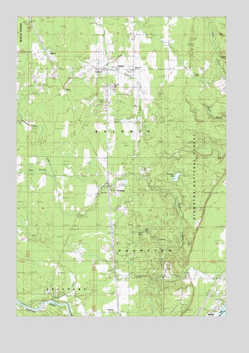
Perkins, MI USGS Topographic Map
Click on map above to begin viewing in our Map Viewer.

This topographic map contains these locations and features:
Feature Name Type Latitude Longitude GNIS ID View Map
Baldwin Township Volunteer Fire DepartmentBuildingN45.9779°W87.0685°2626845View Map
BeaverPopulated PlaceN45.9855°W87.1099°1619136View Map
Bethany ChurchChurchN45.9777°W87.0560°1622617View Map
BramptonPopulated PlaceN45.9314°W87.0713°1619304View Map
Brampton LakeLakeN45.9330°W87.0301°1619305View Map
Brampton Post Office (historical)Post OfficeN45.9314°W87.0714°2354290View Map
Brampton StationLocaleN45.9278°W87.0711°2354291View Map
Brampton Township Volunteer Fire Department Station 1BuildingN45.9290°W87.0698°2626847View Map
ChaisonPopulated PlaceN45.8769°W87.0649°1619471View Map
Gladstone Golf ClubLocaleN45.8958°W87.0328°2351913View Map
Gladstone Ski ParkLocaleN45.8947°W87.0290°1625091View Map
Mid Peninsula SchoolsSchoolN45.9847°W87.1142°2351697View Map
PerkinsPopulated PlaceN45.9777°W87.0718°1621214View Map
Perkins CemeteryCemeteryN45.9710°W87.0691°1621215View Map
Perkins Post OfficePost OfficeN45.9776°W87.0707°2351888View Map
Perkins Station (historical)LocaleN45.9783°W87.0764°2351887View Map
Saint Josephs ChurchChurchN45.9769°W87.0738°1622674View Map
Silver CreekStreamN45.8814°W87.1046°1621604View Map
Township of BaldwinCivilN45.9852°W87.0960°1625875View Map
Township of BramptonCivilN45.9090°W87.0446°1625969View Map
West Branch Days RiverStreamN45.9330°W87.1035°1622094View Map
WindePopulated PlaceN45.9686°W87.0971°1622180View Map
Winde Post Office (historical)Post OfficeN45.9686°W87.0972°2351118View Map
Winde StationLocaleN45.9694°W87.0967°2351117View Map

Note: Coordinates in the location and feature list above are referenced to NAD83 datum.


Copyright (C) 2008-2025 Ryan Niemi / Sunset Dynamics ... All Rights Reserved