TopoQuest Logo
Do you find TopoQuest useful?
Help keep TopoQuest running and adding new maps/features by donating!
Bitcoin:  19c7KJd3qBynnjoSw5npx9KScwjBe4ifkT
Litecoin:  LXs6TkuXGGXo1vDsWCkWVdjQX94eUKd6ui
Home View Maps Find Maps Find Places Resources & Links


Perote, Alabama Topographic Map

USGS Map Title: Perote, AL
USGS Map MRC: 31085H6
DRG (GeoTIFF) Download: o31085h6.tif


Neighboring USGS Topographic Map Quads:


  Almeria, AL  
32085A7
 

  Aberfoil, AL  
32085A6
 

  Midway, AL  
32085A5
 

  Saco, AL  
31085H7
 

  Perote, AL  
31085H6
 

  Mount Andrew, AL  
31085H5
 

  Banks, AL  
31085G7
 

  Josie, AL  
31085G6
 

  Louisville, AL  
31085G5


Map MRC Location:

N32°
W86°
N32°
W85°
H8 H7 H6 H5 H4 H3 H2 H1
G8 G7 G6 G5 G4 G3 G2 G1
F8 F7 F6 F5 F4 F3 F2 F1
E8 E7 E6 E5 E4 E3 E2 E1
D8 D7 D6 D5 D4 D3 D2 D1
C8 C7 C6 C5 C4 C3 C2 C1
B8 B7 B6 B5 B4 B3 B2 B1
A8 A7 A6 A5 A4 A3 A2 A1
N31°
W86°
N31°
W85°

Perote, AL USGS 1:24K Topographic Map Preview:
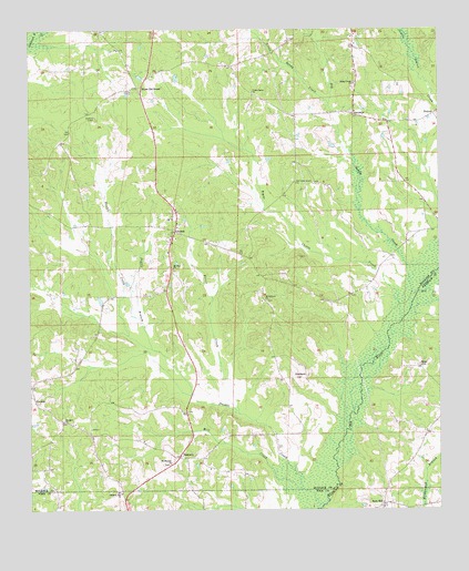
Perote, AL USGS Topographic Map
Click on map above to begin viewing in our Map Viewer.

This topographic map contains these locations and features:
Feature Name Type Latitude Longitude GNIS ID View Map
Big Sandy CreekStreamN31.9279°W85.6336°114317View Map
Blues Old StandPopulated PlaceN31.9849°W85.7169°114601View Map
Bogue Chitta CreekStreamN31.9243°W85.6366°114670View Map
Boot HillPopulated PlaceN31.8760°W85.6424°156097View Map
Coles Store (historical)LocaleN31.8829°W85.7258°135207View Map
Cope CemeteryCemeteryN31.9974°W85.6705°135208View Map
Copes Gin (historical)LocaleN31.9735°W85.6333°135209View Map
Double BranchStreamN31.9171°W85.7127°117404View Map
Double CreekStreamN31.8807°W85.6672°117420View Map
Dry CreekStreamN31.9315°W85.6313°117559View Map
Indian Creek Baptist ChurchChurchN31.9857°W85.6505°155876View Map
JambackPopulated PlaceN31.9102°W85.6652°156521View Map
Little Sandy CreekStreamN31.9810°W85.6586°121879View Map
Littles Bridge (historical)BridgeN31.9143°W85.6449°1805334View Map
McClenny SchoolSchoolN31.9296°W85.6791°135235View Map
Mill CreekStreamN31.8754°W85.6624°122763View Map
Mount Harmon Baptist ChurchChurchN31.8871°W85.7069°152419View Map
Mount Harmon CemeteryCemeteryN31.8871°W85.7077°1805464View Map
Mount Hilliard ChurchChurchN31.9296°W85.6780°123221View Map
Mount Olive ChurchChurchN31.8974°W85.6680°135249View Map
Mount Zion ChurchChurchN31.9379°W85.7058°123457View Map
New Bethsaida Church (historical)ChurchN31.8777°W85.6424°1805343View Map
Old Sellers CemeteryCemeteryN31.9696°W85.7430°149530View Map
Old Union Grove ChurchChurchN31.9602°W85.6683°152804View Map
PerotePopulated PlaceN31.9477°W85.7052°152872View Map
Perote CemeteryCemeteryN31.9452°W85.7072°149531View Map
Perote ChurchChurchN31.9510°W85.7063°149532View Map
Perote CreekStreamN31.9004°W85.6874°124617View Map
Perote High SchoolSchoolN31.9507°W85.7074°165604View Map
Phillips School (historical)SchoolN31.9390°W85.6363°135261View Map
PickettPopulated PlaceN31.9779°W85.6261°156881View Map
Pleasant Hill ChurchChurchN31.8793°W85.7222°124988View Map
Powells Church (historical)ChurchN31.9454°W85.6344°135265View Map
Richardsons Bridge (historical)BridgeN31.8896°W85.6569°1805350View Map
Rogers CemeteryCemeteryN31.9096°W85.6672°135269View Map
Rogers Gin (historical)LocaleN31.9071°W85.6691°135270View Map
Sellers Store (historical)LocaleN31.9757°W85.7361°135279View Map
SmuteyePopulated PlaceN31.9779°W85.6502°157081View Map
Star HillPopulated PlaceN31.9127°W85.6316°157104View Map
TanyardPopulated PlaceN31.8888°W85.7041°127671View Map
Union Grove ChurchChurchN31.9838°W85.6816°153775View Map
Webster ChurchChurchN31.8982°W85.7397°128688View Map

Note: Coordinates in the location and feature list above are referenced to NAD83 datum.


Copyright (C) 2008-2025 Ryan Niemi / Sunset Dynamics ... All Rights Reserved