TopoQuest Logo
Do you find TopoQuest useful?
Help keep TopoQuest running and adding new maps/features by donating!
Bitcoin:  19c7KJd3qBynnjoSw5npx9KScwjBe4ifkT
Litecoin:  LXs6TkuXGGXo1vDsWCkWVdjQX94eUKd6ui
Home View Maps Find Maps Find Places Resources & Links


Berryville, Texas Topographic Map

USGS Map Title: Berryville, TX
USGS Map MRC: 32095A4
DRG (GeoTIFF) Download: o32095a4.tif


Neighboring USGS Topographic Map Quads:


  Moore Station, TX  
32095B5
 

  Saline Bay, TX  
32095B4
 

  Bullard, TX  
32095B3
 

  Poynor, TX  
32095A5
 

  Berryville, TX  
32095A4
 

  Mount Selman, TX  
32095A3
 

  Pert, TX  
31095H5
 

  Todd City, TX  
31095H4
 

  Jacksonville West, TX  
31095H3


Map MRC Location:

N33°
W96°
N33°
W95°
H8 H7 H6 H5 H4 H3 H2 H1
G8 G7 G6 G5 G4 G3 G2 G1
F8 F7 F6 F5 F4 F3 F2 F1
E8 E7 E6 E5 E4 E3 E2 E1
D8 D7 D6 D5 D4 D3 D2 D1
C8 C7 C6 C5 C4 C3 C2 C1
B8 B7 B6 B5 B4 B3 B2 B1
A8 A7 A6 A5 A4 A3 A2 A1
N32°
W96°
N32°
W95°

Berryville, TX USGS 1:24K Topographic Map Preview:
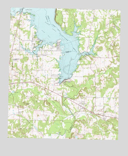
Berryville, TX USGS Topographic Map
Click on map above to begin viewing in our Map Viewer.

This topographic map contains these locations and features:
Feature Name Type Latitude Longitude GNIS ID View Map
Aero Estates AirportAirportN32.0822°W95.4481°1386243View Map
Anderson BluffCliffN32.0579°W95.4430°1329517View Map
BerryvillePopulated PlaceN32.0885°W95.4719°1330463View Map
Berryville City HallBuildingN32.0878°W95.4751°2754021View Map
Berryville Community ChurchChurchN32.0896°W95.4741°2021003View Map
Berryville Volunteer Fire DepartmentBuildingN32.0848°W95.4744°2655254View Map
Blackburn BayBayN32.0718°W95.4283°1330794View Map
Blackburn Crossing DamDamN32.0561°W95.4379°1330796View Map
Blackburn PondLakeN32.0549°W95.4332°1330797View Map
Caddo CreekStreamN32.0129°W95.4272°1331821View Map
Caney BranchStreamN32.0418°W95.4969°1332071View Map
Cherokee BluffsCliffN32.1210°W95.4475°1332705View Map
Cherokee LandingPopulated PlaceN32.0624°W95.4283°1378118View Map
Chimney CoveBayN32.0821°W95.4161°1332755View Map
Cobb CreekStreamN32.0827°W95.4733°1333034View Map
Cobb InletBayN32.0885°W95.4661°1333038View Map
Coffee CityPopulated PlaceN32.1160°W95.4994°1377915View Map
Corinth ChurchChurchN32.1168°W95.4047°1333362View Map
CuneyPopulated PlaceN32.0321°W95.4175°1333813View Map
Cuney Police DepartmentBuildingN32.0317°W95.4183°2751266View Map
Cuney Post OfficePost OfficeN32.0308°W95.4167°2731537View Map
Dunn CreekStreamN32.0868°W95.4858°1329128View Map
Fish BayBayN32.1002°W95.4591°1335817View Map
Flat CreekStreamN32.0468°W95.4216°1335900View Map
Hilltop Baptist ChurchChurchN32.0907°W95.4444°2021044View Map
Honey LakeLakeN32.0062°W95.4420°1338025View Map
Jordan CreekStreamN32.0193°W95.4238°1374323View Map
Kickapoo Battlefield MonumentParkN32.0241°W95.4888°1339076View Map
Kickapoo MountainSummitN32.0329°W95.4808°1339087View Map
Lake PalestineReservoirN32.0552°W95.4386°1854568View Map
Lake Palestine East Volunteer Fire DepartmentBuildingN32.1085°W95.4084°2655328View Map
Ledbetter BayBayN32.1246°W95.4783°1339769View Map
Ledbetter CreekStreamN32.1246°W95.4922°1339771View Map
Ledbetter InletBayN32.1213°W95.4958°1339773View Map
Mount Olive ChurchChurchN32.0591°W95.4716°1342076View Map
Old Rock Hill CemeteryCemeteryN32.0266°W95.3911°1343215View Map
Owens CemeteryCemeteryN32.0343°W95.4838°1343376View Map
Paradise Point AirportAirportN32.0840°W95.4431°2675820View Map
Pleasant Hill CemeteryCemeteryN32.0913°W95.3855°1344205View Map
ReesePopulated PlaceN32.0232°W95.3922°1378947View Map
Renfro CemeteryCemeteryN32.0704°W95.3872°1345040View Map
Rock Hill Restland ParkCemeteryN32.0246°W95.3991°1345384View Map
Running Spring CemeteryCemeteryN32.0093°W95.4711°1345750View Map
Shadybrook Census Designated PlaceCensusN32.1108°W95.4212°2586988View Map
Stone Chimney CreekStreamN32.0788°W95.4219°1347958View Map
Thompson CemeteryCemeteryN32.1018°W95.4083°1348496View Map
Town of BerryvilleCivilN32.0884°W95.4732°2411680View Map
Town of CuneyCivilN32.0374°W95.4147°2412396View Map
Tucker LakeReservoirN32.0021°W95.4222°1864162View Map
Tucker Lake DamDamN32.0035°W95.4219°1864161View Map
Wofford CemeteryCemeteryN32.0585°W95.4686°1350448View Map

Note: Coordinates in the location and feature list above are referenced to NAD83 datum.


Copyright (C) 2008-2024 Ryan Niemi / Sunset Dynamics ... All Rights Reserved