TopoQuest Logo
Do you find TopoQuest useful?
Help keep TopoQuest running and adding new maps/features by donating!
Bitcoin:  19c7KJd3qBynnjoSw5npx9KScwjBe4ifkT
Litecoin:  LXs6TkuXGGXo1vDsWCkWVdjQX94eUKd6ui
Home View Maps Find Maps Find Places Resources & Links


Petteway, Texas Topographic Map

USGS Map Title: Petteway, TX
USGS Map MRC: 31096B5
DRG (GeoTIFF) Download: o31096b5.tif


Neighboring USGS Topographic Map Quads:


  Kosse West, TX  
31096C6
 

  Kosse East, TX  
31096C5
 

  Oletha, TX  
31096C4
 

  Bremond, TX  
31096B6
 

  Petteway, TX  
31096B5
 

  Bald Prairie, TX  
31096B4
 

  Hammond, TX  
31096A6
 

  Owensville, TX  
31096A5
 

  Franklin, TX  
31096A4


Map MRC Location:

N32°
W97°
N32°
W96°
H8 H7 H6 H5 H4 H3 H2 H1
G8 G7 G6 G5 G4 G3 G2 G1
F8 F7 F6 F5 F4 F3 F2 F1
E8 E7 E6 E5 E4 E3 E2 E1
D8 D7 D6 D5 D4 D3 D2 D1
C8 C7 C6 C5 C4 C3 C2 C1
B8 B7 B6 B5 B4 B3 B2 B1
A8 A7 A6 A5 A4 A3 A2 A1
N31°
W97°
N31°
W96°

Petteway, TX USGS 1:24K Topographic Map Preview:
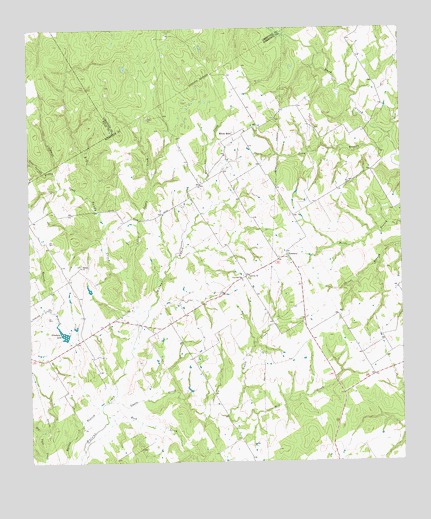
Petteway, TX USGS Topographic Map
Click on map above to begin viewing in our Map Viewer.

This topographic map contains these locations and features:
Feature Name Type Latitude Longitude GNIS ID View Map
Abraham LakeReservoirN31.1625°W96.6141°1350856View Map
Abraham Lake DamDamN31.1618°W96.6119°1858463View Map
Beck CreekStreamN31.1266°W96.6086°1351739View Map
Big Sandy CreekStreamN31.1691°W96.5853°1352122View Map
Claybank CreekStreamN31.2010°W96.6036°1354600View Map
Gnats CreekStreamN31.1427°W96.5983°1358075View Map
Gray Springs BranchStreamN31.2088°W96.6155°1358352View Map
Hurricane CreekStreamN31.1991°W96.5628°1359851View Map
Little Sandy CreekStreamN31.1702°W96.5889°1361465View Map
Long BranchStreamN31.2180°W96.5036°1361694View Map
Mill CreekStreamN31.1385°W96.5589°1362861View Map
PettewayPopulated PlaceN31.1846°W96.5380°1380347View Map
Petteway ChurchChurchN31.1780°W96.5505°1365117View Map
Pool BranchStreamN31.2371°W96.5236°1365573View Map
Post Oak SchoolSchoolN31.1777°W96.5530°1365665View Map
Walnut ChurchChurchN31.1816°W96.6075°1370803View Map
White RockPopulated PlaceN31.2199°W96.5550°1380771View Map

Note: Coordinates in the location and feature list above are referenced to NAD83 datum.


Copyright (C) 2008-2025 Ryan Niemi / Sunset Dynamics ... All Rights Reserved