TopoQuest Logo
Do you find TopoQuest useful?
Help keep TopoQuest running and adding new maps/features by donating!
Bitcoin:  19c7KJd3qBynnjoSw5npx9KScwjBe4ifkT
Litecoin:  LXs6TkuXGGXo1vDsWCkWVdjQX94eUKd6ui
Home View Maps Find Maps Find Places Resources & Links


Bremond, Texas Topographic Map

USGS Map Title: Bremond, TX
USGS Map MRC: 31096B6
DRG (GeoTIFF) Download: o31096b6.tif


Neighboring USGS Topographic Map Quads:


  McClanahan, TX  
31096C7
 

  Kosse West, TX  
31096C6
 

  Kosse East, TX  
31096C5
 

  Reagan, TX  
31096B7
 

  Bremond, TX  
31096B6
 

  Petteway, TX  
31096B5
 

  Baileyville, TX  
31096A7
 

  Hammond, TX  
31096A6
 

  Owensville, TX  
31096A5


Map MRC Location:

N32°
W97°
N32°
W96°
H8 H7 H6 H5 H4 H3 H2 H1
G8 G7 G6 G5 G4 G3 G2 G1
F8 F7 F6 F5 F4 F3 F2 F1
E8 E7 E6 E5 E4 E3 E2 E1
D8 D7 D6 D5 D4 D3 D2 D1
C8 C7 C6 C5 C4 C3 C2 C1
B8 B7 B6 B5 B4 B3 B2 B1
A8 A7 A6 A5 A4 A3 A2 A1
N31°
W97°
N31°
W96°

Bremond, TX USGS 1:24K Topographic Map Preview:
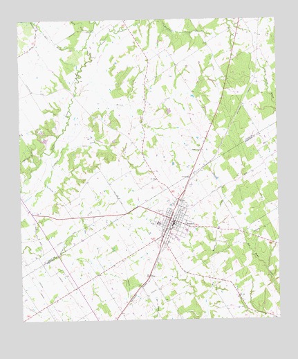
Bremond, TX USGS Topographic Map
Click on map above to begin viewing in our Map Viewer.

This topographic map contains these locations and features:
Feature Name Type Latitude Longitude GNIS ID View Map
BremondPopulated PlaceN31.1652°W96.6769°1352854View Map
Bremond CemeteryCemeteryN31.1707°W96.6836°1352855View Map
Bremond City HallBuildingN31.1647°W96.6743°2753369View Map
Bremond DivisionCivilN31.1282°W96.6582°1938561View Map
Bremond Elementary SchoolSchoolN31.1652°W96.6719°2007987View Map
Bremond High SchoolSchoolN31.1652°W96.6719°2007988View Map
Bremond Middle SchoolSchoolN31.1652°W96.6719°2007989View Map
Bremond Police DepartmentBuildingN31.1648°W96.6742°2739208View Map
Bremond Post OfficePost OfficeN31.1634°W96.6765°2731379View Map
Bremond Volunteer Fire DepartmentBuildingN31.1647°W96.6743°2552269View Map
City of BremondCivilN31.1657°W96.6760°2409900View Map
Cloverleaf Rest CemeteryCemeteryN31.1838°W96.6672°1354685View Map
Harper CemeteryCemeteryN31.1807°W96.6658°1358824View Map
HoggPopulated PlaceN31.1438°W96.6878°1379943View Map
Love High SchoolSchoolN31.1749°W96.6725°1361877View Map
Pleasant Grove ChurchChurchN31.1957°W96.6622°1365412View Map
Polecat CreekStreamN31.2352°W96.7139°1365534View Map
Robertson County Constable's Office Precinct 4BuildingN31.1647°W96.6743°2739438View Map
Rocky CreekStreamN31.2460°W96.7136°1366778View Map
Saint Mary CemeteryCemeteryN31.1724°W96.6708°1367247View Map
Saint Mary SchoolSchoolN31.1710°W96.6719°1367256View Map
Salt BranchStreamN31.2388°W96.7172°1367377View Map
Wachel LakeReservoirN31.2119°W96.6775°1864113View Map
Wachel Lake DamDamN31.2118°W96.6769°1864112View Map
Willow CreekStreamN31.2188°W96.7222°1371627View Map

Note: Coordinates in the location and feature list above are referenced to NAD83 datum.


Copyright (C) 2008-2024 Ryan Niemi / Sunset Dynamics ... All Rights Reserved