TopoQuest Logo
Do you find TopoQuest useful?
Help keep TopoQuest running and adding new maps/features by donating!
Bitcoin:  19c7KJd3qBynnjoSw5npx9KScwjBe4ifkT
Litecoin:  LXs6TkuXGGXo1vDsWCkWVdjQX94eUKd6ui
Home View Maps Find Maps Find Places Resources & Links


Phillipsburg North, Kansas Topographic Map

USGS Map Title: Phillipsburg North, KS
USGS Map MRC: 39099G3
DRG (GeoTIFF) Download: o39099g3.tif


Neighboring USGS Topographic Map Quads:


  Woodruff, KS  
39099H4
 

  Stuttgart NE, KS  
39099H3
 

  Kensington NW, KS  
39099H2
 

  Stuttgart, KS  
39099G4
 

  Phillipsburg North, KS  
39099G3
 

  Gretna, KS  
39099G2
 

  Speed, KS  
39099F4
 

  Phillipsburg South, KS  
39099F3
 

  Kirwin Reservoir, KS  
39099F2


Map MRC Location:

N40°
W100°
N40°
W99°
H8 H7 H6 H5 H4 H3 H2 H1
G8 G7 G6 G5 G4 G3 G2 G1
F8 F7 F6 F5 F4 F3 F2 F1
E8 E7 E6 E5 E4 E3 E2 E1
D8 D7 D6 D5 D4 D3 D2 D1
C8 C7 C6 C5 C4 C3 C2 C1
B8 B7 B6 B5 B4 B3 B2 B1
A8 A7 A6 A5 A4 A3 A2 A1
N39°
W100°
N39°
W99°

Phillipsburg North, KS USGS 1:24K Topographic Map Preview:
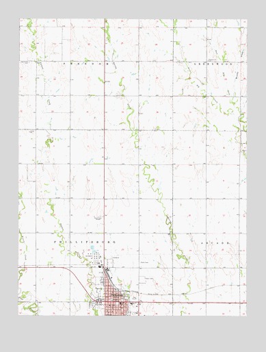
Phillipsburg North, KS USGS Topographic Map
Click on map above to begin viewing in our Map Viewer.

This topographic map contains these locations and features:
Feature Name Type Latitude Longitude GNIS ID View Map
Brushy DrawValleyN39.8406°W99.2555°471930View Map
Calvary Baptist ChurchChurchN39.7552°W99.3164°2690605View Map
Church of ChristChurchN39.7518°W99.3234°2690606View Map
Churchill Airport (historical)AirportN39.7728°W99.3601°481319View Map
City of PhillipsburgCivilN39.7512°W99.3210°485642View Map
First Assembly of God ChurchChurchN39.7514°W99.3255°2690562View Map
First Baptist ChurchChurchN39.7545°W99.3226°2690608View Map
First Lutheran ChurchChurchN39.7596°W99.3276°2690609View Map
First Presbyterian ChurchChurchN39.7583°W99.3248°2690586View Map
Fort Bissell MuseumBuildingN39.7550°W99.3327°2694244View Map
Iowa Union CemeteryCemeteryN39.8566°W99.3699°471929View Map
Jimtown (historical)LocaleN39.8422°W99.3357°482451View Map
Kansas Highway Patrol Troop D PhillipsBuildingN39.7561°W99.3084°2504164View Map
Kingdom Hall of Jehovah's WitnessesChurchN39.7612°W99.3218°2688709View Map
KKAN-AM (Phillipsburg)TowerN39.7922°W99.3323°481554View Map
Phillips CountyCivilN39.7846°W99.3470°485037View Map
Phillips County CourthouseBuildingN39.7564°W99.3237°2625115View Map
Phillips County Emergency Medical ServicesBuildingN39.7584°W99.3226°2696454View Map
Phillips County Health DepartmentBuildingN39.7566°W99.3198°2695048View Map
Phillips County HospitalHospitalN39.7553°W99.3137°2499155View Map
Phillips County Sheriff's OfficeBuildingN39.7565°W99.3238°2504007View Map
PhillipsburgPopulated PlaceN39.7561°W99.3240°471927View Map
Phillipsburg Area Chamber of CommerceBuildingN39.7556°W99.3251°2692876View Map
Phillipsburg City HallBuildingN39.7583°W99.3262°2693206View Map
Phillipsburg City LibraryBuildingN39.7579°W99.3225°2694757View Map
Phillipsburg FairgroundsLocaleN39.7877°W99.3305°2692877View Map
Phillipsburg Fire DepartmentBuildingN39.7585°W99.3228°2111724View Map
Phillipsburg Golf ClubLocaleN39.7577°W99.3118°2694595View Map
Phillipsburg Middle SchoolSchoolN39.7554°W99.3193°2497592View Map
Phillipsburg Post OfficePost OfficeN39.7579°W99.3255°2693917View Map
Phillipsburg United Methodist ChurchChurchN39.7544°W99.3249°2690046View Map
Pleasant Hill CemeteryCemeteryN39.8574°W99.2720°471928View Map
Rangeland Co - Operative Grain Elevator Number 1LocaleN39.7612°W99.3235°2695183View Map
Township of FreedomCivilN39.8716°W99.3469°471761View Map
Township of PhillipsburgCivilN39.7860°W99.3479°471926View Map
Wesleyan ChurchChurchN39.7533°W99.3233°2690612View Map
Worthen Post Office (historical)Post OfficeN39.7503°W99.3337°485497View Map
Zion Lutheran ChurchChurchN39.7534°W99.3183°2690613View Map

Note: Coordinates in the location and feature list above are referenced to NAD83 datum.


Copyright (C) 2008-2025 Ryan Niemi / Sunset Dynamics ... All Rights Reserved