TopoQuest Logo
Do you find TopoQuest useful?
Help keep TopoQuest running and adding new maps/features by donating!
Bitcoin:  19c7KJd3qBynnjoSw5npx9KScwjBe4ifkT
Litecoin:  LXs6TkuXGGXo1vDsWCkWVdjQX94eUKd6ui
Home View Maps Find Maps Find Places Resources & Links


Kirwin Reservoir, Kansas Topographic Map

USGS Map Title: Kirwin Reservoir, KS
USGS Map MRC: 39099F2
DRG (GeoTIFF) Download: o39099f2.tif


Neighboring USGS Topographic Map Quads:


  Phillipsburg North, KS  
39099G3
 

  Gretna, KS  
39099G2
 

  Kensington, KS  
39099G1
 

  Phillipsburg South, KS  
39099F3
 

  Kirwin Reservoir, KS  
39099F2
 

  Kirwin, KS  
39099F1
 

  Glade SE, KS  
39099E3
 

  Kirwin SW, KS  
39099E2
 

  Kirwin SE, KS  
39099E1


Map MRC Location:

N40°
W100°
N40°
W99°
H8 H7 H6 H5 H4 H3 H2 H1
G8 G7 G6 G5 G4 G3 G2 G1
F8 F7 F6 F5 F4 F3 F2 F1
E8 E7 E6 E5 E4 E3 E2 E1
D8 D7 D6 D5 D4 D3 D2 D1
C8 C7 C6 C5 C4 C3 C2 C1
B8 B7 B6 B5 B4 B3 B2 B1
A8 A7 A6 A5 A4 A3 A2 A1
N39°
W100°
N39°
W99°

Kirwin Reservoir, KS USGS 1:24K Topographic Map Preview:
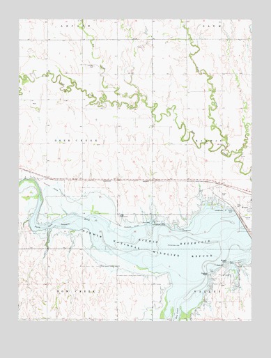
Kirwin Reservoir, KS USGS Topographic Map
Click on map above to begin viewing in our Map Viewer.

This topographic map contains these locations and features:
Feature Name Type Latitude Longitude GNIS ID View Map
Big CreekStreamN39.7189°W99.1862°471933View Map
Bluegill PointCapeN39.6495°W99.1379°472050View Map
Bow CreekStreamN39.6578°W99.1387°472042View Map
Crappie PointCapeN39.6445°W99.1481°472049View Map
Eastern Heights Elementary SchoolSchoolN39.6751°W99.1257°2497353View Map
Hillsdale CemeteryCemeteryN39.7307°W99.2100°472046View Map
Kirin CemeteryCemeteryN39.6787°W99.1424°472045View Map
Kirwin Encampment (historical)LocaleN39.6542°W99.1462°482048View Map
Kirwin National Wildlife RefugeParkN39.6538°W99.1834°472041View Map
Kirwin ReservoirReservoirN39.6560°W99.1610°472040View Map
Kirwin Wildlife AreaParkN39.6545°W99.1815°479781View Map
Plum CreekStreamN39.6958°W99.1395°471934View Map
Township of Deer CreekCivilN39.6981°W99.2347°472034View Map
Turner CreekStreamN39.6950°W99.1323°471936View Map
Wyrill Farming AirportAirportN39.6786°W99.1266°2717312View Map

Note: Coordinates in the location and feature list above are referenced to NAD83 datum.


Copyright (C) 2008-2025 Ryan Niemi / Sunset Dynamics ... All Rights Reserved