TopoQuest Logo
Do you find TopoQuest useful?
Help keep TopoQuest running and adding new maps/features by donating!
Bitcoin:  19c7KJd3qBynnjoSw5npx9KScwjBe4ifkT
Litecoin:  LXs6TkuXGGXo1vDsWCkWVdjQX94eUKd6ui
Home View Maps Find Maps Find Places Resources & Links


Phoenix, Louisiana Topographic Map

USGS Map Title: Phoenix, LA
USGS Map MRC: 29089F8
DRG (GeoTIFF) Download: o29089f8.tif


Neighboring USGS Topographic Map Quads:


  Bertrandville, LA  
29090G1
 

  Belle Chasse, LA  
29089G8
 

  Delacroix, LA  
29089G7
 

  Lafitte, LA  
29090F1
 

  Phoenix, LA  
29089F8


  Three Bayou Bay, LA  
29090E1


Map MRC Location:

N30°
W90°
N30°
W89°
H8 H7 H6 H5 H4 H3 H2 H1
G8 G7 G6 G5 G4 G3 G2 G1
F8 F7 F6 F5 F4 F3 F2 F1
E8 E7 E6 E5 E4 E3 E2 E1
D8 D7 D6 D5 D4 D3 D2 D1
C8 C7 C6 C5 C4 C3 C2 C1
B8 B7 B6 B5 B4 B3 B2 B1
A8 A7 A6 A5 A4 A3 A2 A1
N29°
W90°
N29°
W89°

Phoenix, LA USGS 1:24K Topographic Map Preview:
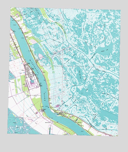
Phoenix, LA USGS Topographic Map
Click on map above to begin viewing in our Map Viewer.

This topographic map contains these locations and features:
Feature Name Type Latitude Longitude GNIS ID View Map
AlliancePopulated PlaceN29.6885°W89.9817°542919View Map
Alliance RevetmentLeveeN29.6927°W89.9767°558603View Map
Bayou GarelleBayN29.6754°W89.9169°532602View Map
Beaumar PlantationLocaleN29.6902°W89.9620°558610View Map
BelairPopulated PlaceN29.7205°W89.9823°558168View Map
Belair CanalBayN29.7166°W89.9440°532900View Map
Belair CemeteryCemeteryN29.7252°W89.9840°532901View Map
BurbridgePopulated PlaceN29.6744°W89.9562°558621View Map
BurnbridgePopulated PlaceN29.6752°W89.9540°542217View Map
CarlislePopulated PlaceN29.6869°W89.9623°541063View Map
Carlisle Post OfficePost OfficeN29.6827°W89.9598°1632304View Map
Caskett BayouBayN29.7158°W89.8922°533802View Map
Fairview CanalBayN29.7076°W89.9427°534879View Map
Fort De La Boulaye (historical)MilitaryN29.6492°W89.9444°558643View Map
Forty Arpent CanalBayN29.7458°W89.9699°558225View Map
Harlem RevetmentLeveeN29.6288°W89.9109°558653View Map
Horsepower CanalBayN29.6577°W89.8923°535810View Map
IrontonPopulated PlaceN29.6488°W89.9615°543333View Map
Ironton CemeteryCemeteryN29.6472°W89.9606°558655View Map
Jim Williams CanalBayN29.7069°W89.9231°536048View Map
Joe Gravolet CanalBayN29.6571°W89.9357°536061View Map
La ReussitePopulated PlaceN29.7008°W89.9876°542220View Map
Little Oak PondBayN29.6848°W89.9201°536584View Map
Lorez CanalCanalN29.6405°W89.9220°536732View Map
MonsecourPopulated PlaceN29.6702°W89.9540°542218View Map
Monsecour RevetmentLeveeN29.6666°W89.9556°558667View Map
Myrtle GrovePopulated PlaceN29.6374°W89.9492°558271View Map
Myrtle Grove RevetmentLeveeN29.6391°W89.9470°558670View Map
NaomiPopulated PlaceN29.7102°W89.9923°537518View Map
PhoenixPopulated PlaceN29.6460°W89.9398°543575View Map
Phoenix Gas FieldOilfieldN29.6544°W89.9351°558679View Map
Phoenix High SchoolSchoolN29.6445°W89.9288°558680View Map
Plaquemines Parish Sheriff's OfficeBuildingN29.6262°W89.9314°2334024View Map
Poverty PointCapeN29.6522°W89.9523°538370View Map
ReussitePopulated PlaceN29.7010°W89.9862°558698View Map
Riverbend Nursing and Rehabilitation CenterBuildingN29.7275°W89.9992°2601109View Map
Saint John ChurchChurchN29.6474°W89.9384°558699View Map
Saint Joseph ChurchChurchN29.6458°W89.9362°558701View Map
Saint Pauls Baptist ChurchChurchN29.6489°W89.9617°2602738View Map
Saint RosaliePopulated PlaceN29.6638°W89.9695°541184View Map
Schayots CanalBayN29.6677°W89.9119°539210View Map
Shell BayouBayN29.7055°W89.9040°539314View Map
Spanish LakeBayN29.7101°W89.8906°539539View Map
Spanish Lake Gas FieldOilfieldN29.7280°W89.8976°558712View Map
Spanish Lake Oil FieldOilfieldN29.6788°W89.9001°558713View Map
Star Spur (historical)LocaleN29.7197°W89.9976°558716View Map
Sun BayouBayN29.7139°W89.9059°539723View Map
Timber CanalCanalN29.6391°W89.9723°539942View Map

Note: Coordinates in the location and feature list above are referenced to NAD83 datum.


Copyright (C) 2008-2025 Ryan Niemi / Sunset Dynamics ... All Rights Reserved