TopoQuest Logo
Do you find TopoQuest useful?
Help keep TopoQuest running and adding new maps/features by donating!
Bitcoin:  19c7KJd3qBynnjoSw5npx9KScwjBe4ifkT
Litecoin:  LXs6TkuXGGXo1vDsWCkWVdjQX94eUKd6ui
Home View Maps Find Maps Find Places Resources & Links


Delacroix, Louisiana Topographic Map

USGS Map Title: Delacroix, LA
USGS Map MRC: 29089G7
DRG (GeoTIFF) Download: o29089g7.tif


Neighboring USGS Topographic Map Quads:


  Chalmette, LA  
29089H8
 

  Martello Castle, LA  
29089H7
 

  Proctor Point, LA  
29089H6
 

  Belle Chasse, LA  
29089G8
 

  Delacroix, LA  
29089G7
 

  Yscloskey, LA  
29089G6
 

  Phoenix, LA  
29089F8


Map MRC Location:

N30°
W90°
N30°
W89°
H8 H7 H6 H5 H4 H3 H2 H1
G8 G7 G6 G5 G4 G3 G2 G1
F8 F7 F6 F5 F4 F3 F2 F1
E8 E7 E6 E5 E4 E3 E2 E1
D8 D7 D6 D5 D4 D3 D2 D1
C8 C7 C6 C5 C4 C3 C2 C1
B8 B7 B6 B5 B4 B3 B2 B1
A8 A7 A6 A5 A4 A3 A2 A1
N29°
W90°
N29°
W89°

Delacroix, LA USGS 1:24K Topographic Map Preview:
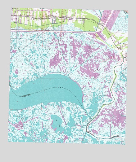
Delacroix, LA USGS Topographic Map
Click on map above to begin viewing in our Map Viewer.

This topographic map contains these locations and features:
Feature Name Type Latitude Longitude GNIS ID View Map
Bayou Gentilly Gas FieldOilfieldN29.7563°W89.8195°558608View Map
Bayou LeryBayN29.7778°W89.7907°560004View Map
Canal MarineBayN29.7643°W89.8626°533681View Map
ContrerasPopulated PlaceN29.8655°W89.7867°1629379View Map
Creedmore CanalBayN29.8276°W89.8391°560529View Map
Creedmore ChurchChurchN29.8652°W89.8428°560530View Map
DelacroixPopulated PlaceN29.7616°W89.7909°560617View Map
Delacroix IslandIslandN29.7697°W89.7876°560618View Map
Ducros MuseumBuildingN29.8680°W89.8603°2703461View Map
Eighty Arpent CanalBayN29.8160°W89.8238°560699View Map
Fanz Mobile Home ParkPopulated PlaceN29.8717°W89.8354°2600853View Map
Howards DitchCanalN29.8258°W89.7781°1627308View Map
Jacks CanalBayN29.8027°W89.7527°1627344View Map
Jourda CanalCanalN29.8558°W89.8006°1627378View Map
KenilworthPopulated PlaceN29.8669°W89.8187°1627396View Map
Kenilworth CanalCanalN29.8402°W89.8134°1627397View Map
KQLD-FM (Port Sulphur)TowerN29.8085°W89.7617°1633103View Map
Lake LeryBayN29.7967°W89.8352°1627475View Map
Lake Lery Gas FieldOilfieldN29.7608°W89.8542°1629540View Map
Lost LakeBayN29.7676°W89.8238°555168View Map
Magnolia CanalCanalN29.8402°W89.8137°1627594View Map
New CanalCanalN29.8735°W89.7534°1627760View Map
Olivier CanalCanalN29.8288°W89.7926°1627836View Map
P G T Beauregard Middle School (historical)SchoolN29.8685°W89.8651°1629399View Map
ReggioPopulated PlaceN29.8313°W89.7545°1628038View Map
Saint BernardPopulated PlaceN29.8672°W89.8587°1628099View Map
Saint Bernard Catholic ChurchChurchN29.8674°W89.8175°2602612View Map
Saint Bernard Middle SchoolSchoolN29.8742°W89.8738°1628102View Map
Saint Bernard Parish Fire Department Station 10BuildingN29.8600°W89.7756°2691758View Map
Saint Bernard Parish Fire Department Station 12BuildingN29.7764°W89.7813°2691685View Map
Saint Bernard Parish Fire Department Station 8BuildingN29.8678°W89.8744°2691646View Map
Saint Bernard Parish Library Ducros Museum Branch (historical)BuildingN29.8680°W89.8603°2603118View Map
Saint Bernard Post OfficePost OfficeN29.8680°W89.8649°1632353View Map
Saint Mary CanalCanalN29.8366°W89.8009°1628141View Map
SebastopolPopulated PlaceN29.8677°W89.8728°1628194View Map
Sebastopol CanalBayN29.8409°W89.8731°1628195View Map
Sideline Mobile Home ParkPopulated PlaceN29.8708°W89.8735°2600910View Map
Southern Natural Gas Company HeliportAirportN29.8649°W89.8301°1632931View Map
Third Missionary Baptist ChurchChurchN29.8688°W89.8609°2602872View Map
TocaPopulated PlaceN29.8666°W89.8365°1628370View Map
True Love CemeteryCemeteryN29.8624°W89.8731°1628384View Map
VerretPopulated PlaceN29.8619°W89.7798°1628427View Map
Ward KCivilN29.8441°W89.7790°1628577View Map
Whitehall CanalBayN29.8467°W89.8249°1628497View Map
Wood LakePopulated PlaceN29.8074°W89.7642°1628526View Map

Note: Coordinates in the location and feature list above are referenced to NAD83 datum.


Copyright (C) 2008-2025 Ryan Niemi / Sunset Dynamics ... All Rights Reserved