TopoQuest Logo
Do you find TopoQuest useful?
Help keep TopoQuest running and adding new maps/features by donating!
Bitcoin:  19c7KJd3qBynnjoSw5npx9KScwjBe4ifkT
Litecoin:  LXs6TkuXGGXo1vDsWCkWVdjQX94eUKd6ui
Home View Maps Find Maps Find Places Resources & Links


Pikeville, Tennessee Topographic Map

USGS Map Title: Pikeville, TN
USGS Map MRC: 35085E2
DRG (GeoTIFF) Download: o35085e2.tif


Neighboring USGS Topographic Map Quads:


  Sampson, TN  
35085F3
 

  Billingsley Gap, TN  
35085F2
 

  Melvine, TN  
35085F1
 

  Brockdell, TN  
35085E3
 

  Pikeville, TN  
35085E2
 

  Morgan Springs, TN  
35085E1
 

  Mount Airy, TN  
35085D3
 

  Brayton, TN  
35085D2
 

  Graysville, TN  
35085D1


Map MRC Location:

N36°
W86°
N36°
W85°
H8 H7 H6 H5 H4 H3 H2 H1
G8 G7 G6 G5 G4 G3 G2 G1
F8 F7 F6 F5 F4 F3 F2 F1
E8 E7 E6 E5 E4 E3 E2 E1
D8 D7 D6 D5 D4 D3 D2 D1
C8 C7 C6 C5 C4 C3 C2 C1
B8 B7 B6 B5 B4 B3 B2 B1
A8 A7 A6 A5 A4 A3 A2 A1
N35°
W86°
N35°
W85°

Pikeville, TN USGS 1:24K Topographic Map Preview:
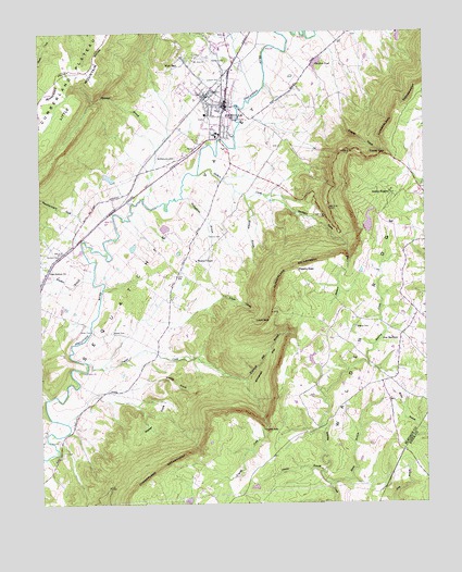
Pikeville, TN USGS Topographic Map
Click on map above to begin viewing in our Map Viewer.

This topographic map contains these locations and features:
Feature Name Type Latitude Longitude GNIS ID View Map
Abc DamDamN35.5801°W85.1433°1301938View Map
Abc LakeReservoirN35.5801°W85.1433°1301937View Map
Bethel CemeteryCemeteryN35.5456°W85.2263°1277108View Map
Bledsoe CountyCivilN35.5964°W85.2052°1639725View Map
Bledsoe County EMSBuildingN35.5948°W85.1993°2697366View Map
Bledsoe County High SchoolSchoolN35.5984°W85.1922°1317999View Map
Bledsoe County Sheriff's OfficeBuildingN35.6139°W85.1953°2766005View Map
Bracken BranchStreamN35.5601°W85.2325°1278139View Map
Burns LakeReservoirN35.5866°W85.2272°1301940View Map
Burns Lake DamDamN35.5851°W85.2266°1301941View Map
City of PikevilleCivilN35.6095°W85.1933°2404519View Map
Civilian Conservation Corps Camp Number 1466 (historical)LocaleN35.6103°W85.1741°1318004View Map
Commissioner District 4CivilN35.6069°W85.1904°2464012View Map
Crystal CreekStreamN35.5376°W85.2347°1281779View Map
Crystal FallsFallsN35.5198°W85.1779°1281780View Map
Dinner BranchStreamN35.5084°W85.1588°1282483View Map
Erlanger Bledsoe HospitalHospitalN35.6207°W85.1909°2697325View Map
Flatwood BranchStreamN35.5809°W85.2158°1284450View Map
Fraley CoveValleyN35.6023°W85.1516°1284794View Map
Fraley GapGapN35.5931°W85.1380°1284795View Map
Fraley Gap MineMineN35.5912°W85.1408°1318010View Map
Gerren HeightsPopulated PlaceN35.5826°W85.1352°1285322View Map
Greer FordCrossingN35.5462°W85.2336°1315161View Map
Hembree Mill (historical)LocaleN35.5601°W85.2322°1318018View Map
Henson CemeteryCemeteryN35.6178°W85.1891°1287476View Map
Humble CemeteryCemeteryN35.5664°W85.2477°1288695View Map
Keedy CoveValleyN35.5321°W85.2159°1289940View Map
Lees Station ChurchChurchN35.5623°W85.2483°1290983View Map
Lincoln SchoolSchoolN35.6123°W85.1900°1291312View Map
Loyd CoveValleyN35.5550°W85.1906°1292249View Map
Loyd GapGapN35.5490°W85.1758°1292250View Map
Loyd SpringSpringN35.5978°W85.1591°1311062View Map
Markem BranchStreamN35.5809°W85.1827°1292690View Map
McReynolds BranchStreamN35.5820°W85.2030°1293467View Map
McReynolds CemeteryCemeteryN35.5917°W85.2055°1293468View Map
Mount Zion ChurchChurchN35.6176°W85.1991°1294882View Map
New Harmonoy Church of ChristChurchN35.5406°W85.1333°1318034View Map
New HarmonyPopulated PlaceN35.5456°W85.1327°1315589View Map
New Harmony Church (historical)ChurchN35.5403°W85.1275°1318033View Map
New Harmony School (historical)SchoolN35.5423°W85.1338°1318035View Map
Oak Grove Church (historical)ChurchN35.5120°W85.2444°1318037View Map
Penitentiary GulfValleyN35.5768°W85.2379°1297147View Map
PikevillePopulated PlaceN35.6056°W85.1888°1297464View Map
Pikeville Elementary SchoolSchoolN35.5973°W85.1925°1318039View Map
Pikeville Police DepartmentBuildingN35.6068°W85.1896°2766006View Map
Pikeville Post OfficePost OfficeN35.6090°W85.1881°1650929View Map
Pikeville Volunteer Fire DepartmentBuildingN35.6163°W85.1865°2654344View Map
Rigsby CemeteryCemeteryN35.5473°W85.1472°1299444View Map
Rigsby GapGapN35.5623°W85.1661°1299445View Map
Sequatchie Valley Division (historical)CensusN35.5987°W85.1930°1648605View Map
Skillern CoveValleyN35.5800°W85.1710°1303650View Map
Skillern CreekStreamN35.5876°W85.1983°1303651View Map
Sloan BranchStreamN35.5053°W85.1558°1270531View Map
Spring BranchStreamN35.5284°W85.2477°1271057View Map
Swafford PondLakeN35.6167°W85.1596°1271922View Map
The PenitentiaryValleyN35.6066°W85.2316°1311067View Map
Twin Lakes Number Three DamDamN35.6231°W85.1333°1301973View Map
Twin Lakes Number Three LakeReservoirN35.6233°W85.1328°1301972View Map
Vernon CemeteryCemeteryN35.5712°W85.1947°1273427View Map
Walden Ridge Division (historical)CensusN35.5528°W85.1305°1648606View Map
Walker CoveValleyN35.5276°W85.2083°1273619View Map
Wesley ChapelChurchN35.5645°W85.1991°1304448View Map
West EndPopulated PlaceN35.6187°W85.2030°1274148View Map
Whiteoak FlatFlatN35.5370°W85.1763°1304550View Map
Whiteoak Flat BranchStreamN35.5390°W85.1988°1304551View Map
WUAT-AM (Pikeville)TowerN35.6051°W85.1872°1639870View Map

Note: Coordinates in the location and feature list above are referenced to NAD83 datum.


Copyright (C) 2008-2025 Ryan Niemi / Sunset Dynamics ... All Rights Reserved