TopoQuest Logo
Do you find TopoQuest useful?
Help keep TopoQuest running and adding new maps/features by donating!
Bitcoin:  19c7KJd3qBynnjoSw5npx9KScwjBe4ifkT
Litecoin:  LXs6TkuXGGXo1vDsWCkWVdjQX94eUKd6ui
Home View Maps Find Maps Find Places Resources & Links


Pine Forest, Texas Topographic Map

USGS Map Title: Pine Forest, TX
USGS Map MRC: 30094B1
DRG (GeoTIFF) Download: o30094b1.tif


Neighboring USGS Topographic Map Quads:


  Silsbee, TX  
30094C2
 

  Evadale, TX  
30094C1
 

  Gist, TX  
30093C8
 

  Voth, TX  
30094B2
 

  Pine Forest, TX  
30094B1
 

  Texla, TX  
30093B8
 

  Beaumont West, TX  
30094A2
 

  Beaumont East, TX  
30094A1
 

  Terry, TX  
30093A8


Map MRC Location:

N31°
W95°
N31°
W94°
H8 H7 H6 H5 H4 H3 H2 H1
G8 G7 G6 G5 G4 G3 G2 G1
F8 F7 F6 F5 F4 F3 F2 F1
E8 E7 E6 E5 E4 E3 E2 E1
D8 D7 D6 D5 D4 D3 D2 D1
C8 C7 C6 C5 C4 C3 C2 C1
B8 B7 B6 B5 B4 B3 B2 B1
A8 A7 A6 A5 A4 A3 A2 A1
N30°
W95°
N30°
W94°

Pine Forest, TX USGS 1:24K Topographic Map Preview:
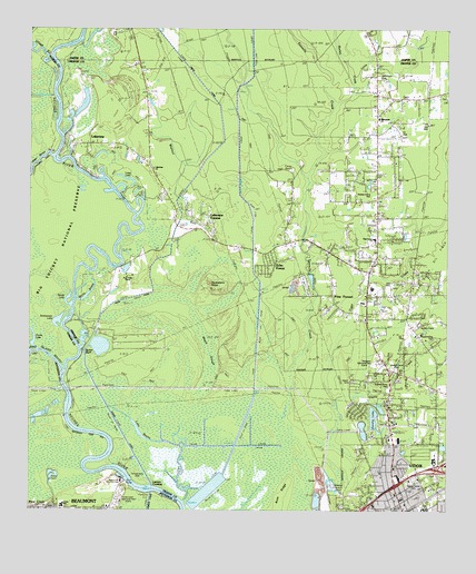
Pine Forest, TX USGS Topographic Map
Click on map above to begin viewing in our Map Viewer.

This topographic map contains these locations and features:
Feature Name Type Latitude Longitude GNIS ID View Map
Banks BayouLakeN30.1805°W94.1084°1330008View Map
Beaumont Country ClubLocaleN30.1322°W94.0971°1384291View Map
Big Thicket National PreserveParkN30.1991°W94.1160°1330671View Map
Bunns BluffCliffN30.1680°W94.1085°1331656View Map
Bunns CanalCanalN30.1477°W94.0988°1331657View Map
Busley CreekStreamN30.2297°W94.0343°1340201View Map
Caney CreekStreamN30.1530°W94.0330°1332081View Map
City of Pine ForestCivilN30.1756°W94.0367°2411423View Map
Colliers FerryLocaleN30.1324°W94.0941°1333115View Map
Cooks LakeLakeN30.1697°W94.1235°1373191View Map
Cornerstone Baptist ChurchChurchN30.1619°W94.0177°2022928View Map
Echo ForestPopulated PlaceN30.1894°W94.0532°1384890View Map
Evangeline Drive Baptist ChurchChurchN30.1594°W94.0102°2022864View Map
Faith Baptist ChurchChurchN30.1444°W94.0213°2022865View Map
First Apostolic ChurchChurchN30.1430°W94.0057°2022922View Map
First Baptist Church of VidorChurchN30.1285°W94.0143°2022867View Map
First Pentecostal ChurchChurchN30.1260°W94.0121°2022844View Map
First Presbyterian Church of VidorChurchN30.1372°W94.0027°2022848View Map
Forest Lawn Memorial ParkCemeteryN30.1277°W94.0985°1373751View Map
Four Oaks RanchLocaleN30.1866°W94.0980°1336102View Map
Grace Baptist ChurchChurchN30.1524°W94.0180°2022870View Map
Huckleberry RidgeRidgeN30.1819°W94.0696°1338212View Map
Lake BayouLakeN30.1458°W94.0922°1339483View Map
LakeviewPopulated PlaceN30.2202°W94.1085°1339542View Map
Lakeview ChurchChurchN30.2138°W94.0880°1339545View Map
Lakeview EstatesPopulated PlaceN30.2022°W94.0741°1384889View Map
Lawson CrossingPopulated PlaceN30.1310°W94.0882°1378571View Map
Little CreekStreamN30.2355°W94.0285°1331739View Map
Long LakeLakeN30.2110°W94.0961°1340491View Map
Lucas Elementary SchoolSchoolN30.1259°W94.1151°2007225View Map
Maple SloughGutN30.1649°W94.0705°1340914View Map
Morgan ParkParkN30.1291°W94.1202°2029712View Map
Orange County Constable's Office Precinct 4BuildingN30.1263°W94.0123°2376006View Map
Orange County Emergency Services District 1 Station 1BuildingN30.1255°W94.0124°2334312View Map
Orange County Emergency Services District 1 Station 2BuildingN30.1880°W94.0233°2655505View Map
Orange County Rural Fire DistrictBuildingN30.1263°W94.0123°2334509View Map
Orange County Sheriff's Office - VidorBuildingN30.1342°W94.0030°2375836View Map
Parsonage Nw Baptist ChurchChurchN30.1355°W94.0199°2022877View Map
Pine ForestPopulated PlaceN30.1813°W94.0343°1344043View Map
Pine Forest Baptist ChurchChurchN30.1905°W94.0207°2022878View Map
Pine Forest ChurchChurchN30.1960°W94.0216°1344044View Map
Pine Forest Elementary SchoolSchoolN30.1830°W94.0232°2008208View Map
Pine Forest First Pentecostal ChurchChurchN30.1935°W94.0205°2022846View Map
Pine Island BayouStreamN30.1610°W94.1157°1375466View Map
Restlawn Memorial ParkCemeteryN30.1630°W94.0216°1345107View Map
Sandy LakeLakeN30.1785°W94.1135°1346602View Map
Scatterman LakeLakeN30.1743°W94.1168°1346751View Map
Shiloh Baptist ChurchChurchN30.1577°W94.0060°2022882View Map
Smiths LakeLakeN30.1491°W94.0220°1384891View Map
Tenmile CreekStreamN30.1605°W94.0468°1348361View Map
VidorPopulated PlaceN30.1316°W94.0155°1349270View Map
Vidor City HallBuildingN30.1439°W94.0169°2753614View Map
Vidor DivisionCivilN30.1620°W94.0026°1939292View Map
Vidor Junior High SchoolSchoolN30.1383°W94.0036°2008212View Map
Vidor North Oil FieldOilfieldN30.1888°W94.0057°1349271View Map
Vidor Police DepartmentBuildingN30.1298°W94.0048°2375951View Map
Vidor Post OfficePost OfficeN30.1260°W94.0153°2731249View Map
Village CreekStreamN30.2419°W94.1182°1376595View Map
Walnut RunStreamN30.1902°W94.0674°1349445View Map
Weiss CanalCanalN30.2085°W94.0780°1376673View Map
Williamson CemeteryCemeteryN30.2377°W94.0205°1350155View Map
Williamson ChurchChurchN30.2269°W94.0205°1350156View Map

Note: Coordinates in the location and feature list above are referenced to NAD83 datum.


Copyright (C) 2008-2024 Ryan Niemi / Sunset Dynamics ... All Rights Reserved