TopoQuest Logo
Do you find TopoQuest useful?
Help keep TopoQuest running and adding new maps/features by donating!
Bitcoin:  19c7KJd3qBynnjoSw5npx9KScwjBe4ifkT
Litecoin:  LXs6TkuXGGXo1vDsWCkWVdjQX94eUKd6ui
Home View Maps Find Maps Find Places Resources & Links


Evadale, Texas Topographic Map

USGS Map Title: Evadale, TX
USGS Map MRC: 30094C1
DRG (GeoTIFF) Download: o30094c1.tif


Neighboring USGS Topographic Map Quads:


  Deserter Baygall, TX  
30094D2
 

  Franklin Lake, TX  
30094D1
 

  Buna, TX  
30093D8
 

  Silsbee, TX  
30094C2
 

  Evadale, TX  
30094C1
 

  Gist, TX  
30093C8
 

  Voth, TX  
30094B2
 

  Pine Forest, TX  
30094B1
 

  Texla, TX  
30093B8


Map MRC Location:

N31°
W95°
N31°
W94°
H8 H7 H6 H5 H4 H3 H2 H1
G8 G7 G6 G5 G4 G3 G2 G1
F8 F7 F6 F5 F4 F3 F2 F1
E8 E7 E6 E5 E4 E3 E2 E1
D8 D7 D6 D5 D4 D3 D2 D1
C8 C7 C6 C5 C4 C3 C2 C1
B8 B7 B6 B5 B4 B3 B2 B1
A8 A7 A6 A5 A4 A3 A2 A1
N30°
W95°
N30°
W94°

Evadale, TX USGS 1:24K Topographic Map Preview:
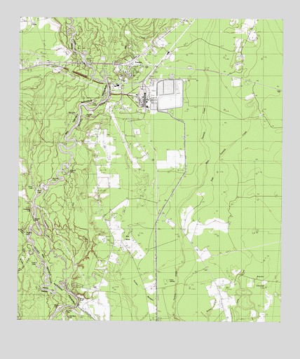
Evadale, TX USGS Topographic Map
Click on map above to begin viewing in our Map Viewer.

This topographic map contains these locations and features:
Feature Name Type Latitude Longitude GNIS ID View Map
Alligator LakeLakeN30.2858°W94.1221°1329423View Map
Bellrose SloughGutN30.2663°W94.1227°1330389View Map
Ben Bruce Memorial AirparkAirportN30.3264°W94.0760°1386619View Map
Big Eddy LakeLakeN30.3078°W94.1104°1377256View Map
Big Mac LakeLakeN30.2539°W94.1026°1330622View Map
Brushy BluffCliffN30.2919°W94.1174°1331409View Map
Cockerham LakeLakeN30.2945°W94.1185°1333051View Map
Coon SwampSwampN30.2744°W94.0535°1333294View Map
Craig CemeteryCemeteryN30.3633°W94.0735°1333616View Map
East Tenmile CreekStreamN30.2860°W94.0468°1335002View Map
EvadalePopulated PlaceN30.3549°W94.0727°1335544View Map
Evadale Census Designated PlaceCensusN30.3369°W94.0600°2408094View Map
Evadale Fire Lookout TowerTowerN30.2713°W94.0371°1384372View Map
Evadale Post OfficePost OfficeN30.3555°W94.0721°2732304View Map
Evadale Volunteer Fire DepartmentBuildingN30.3456°W94.0775°2334437View Map
Fourmile LakeLakeN30.2883°W94.1121°1336121View Map
Gentry LakeLakeN30.3047°W94.1178°1336475View Map
Jasper County Constable's Office Precinct 6BuildingN30.3523°W94.0737°2751476View Map
Jasper County Sheriff's OfficeBuildingN30.3523°W94.0737°2375853View Map
Johnsons EddyRapidsN30.3105°W94.1013°1338819View Map
Laurel LakeLakeN30.2716°W94.1152°1339715View Map
LillardPopulated PlaceN30.3552°W94.1182°1339919View Map
Little Bellrose SloughGutN30.2733°W94.1238°1340019View Map
Little Mac LakeLakeN30.2508°W94.1020°1340135View Map
Mill CreekStreamN30.3510°W94.0841°1374940View Map
Mud LakeLakeN30.3354°W94.0995°1342206View Map
Neyland LakeLakeN30.3340°W94.0937°1342581View Map
Rich MarshSwampN30.2844°W94.0730°1345167View Map
Shinny LakeLakeN30.2556°W94.1052°1347075View Map
Starks ThicketWoodsN30.2669°W94.0132°1347820View Map
TemcoPopulated PlaceN30.3599°W94.0668°1379146View Map
The CutoffStreamN30.2641°W94.1024°1348440View Map
Turkey BaygallSwampN30.2610°W94.0655°1348848View Map
Twin LakesLakeN30.3395°W94.0921°1348949View Map
Ward LakeLakeN30.3033°W94.1166°1349474View Map
West Tenmile CreekStreamN30.2860°W94.0468°1349817View Map
Wiess BluffCliffN30.2574°W94.0960°1350042View Map
Wiess CanalCanalN30.2510°W94.0899°1376781View Map

Note: Coordinates in the location and feature list above are referenced to NAD83 datum.


Copyright (C) 2008-2025 Ryan Niemi / Sunset Dynamics ... All Rights Reserved