TopoQuest Logo
Do you find TopoQuest useful?
Help keep TopoQuest running and adding new maps/features by donating!
Bitcoin:  19c7KJd3qBynnjoSw5npx9KScwjBe4ifkT
Litecoin:  LXs6TkuXGGXo1vDsWCkWVdjQX94eUKd6ui
Home View Maps Find Maps Find Places Resources & Links


Pineland North, Texas Topographic Map

USGS Map Title: Pineland North, TX
USGS Map MRC: 31093C8
DRG (GeoTIFF) Download: o31093c8.tif


Neighboring USGS Topographic Map Quads:


  Chinquapin, TX  
31094D1
 

  Geneva, TX  
31093D8
 

  Milam, TX  
31093D7
 

  Bronson, TX  
31094C1
 

  Pineland North, TX  
31093C8
 

  Hemphill, TX  
31093C7
 

  Buck Bay, TX  
31094B1
 

  Pineland South, TX  
31093B8
 

  Hurricane Creek, TX  
31093B7


Map MRC Location:

N32°
W94°
N32°
W93°
H8 H7 H6 H5 H4 H3 H2 H1
G8 G7 G6 G5 G4 G3 G2 G1
F8 F7 F6 F5 F4 F3 F2 F1
E8 E7 E6 E5 E4 E3 E2 E1
D8 D7 D6 D5 D4 D3 D2 D1
C8 C7 C6 C5 C4 C3 C2 C1
B8 B7 B6 B5 B4 B3 B2 B1
A8 A7 A6 A5 A4 A3 A2 A1
N31°
W94°
N31°
W93°

Pineland North, TX USGS 1:24K Topographic Map Preview:
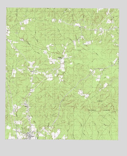
Pineland North, TX USGS Topographic Map
Click on map above to begin viewing in our Map Viewer.

This topographic map contains these locations and features:
Feature Name Type Latitude Longitude GNIS ID View Map
Bennett Branch CreekStreamN31.3355°W93.8996°1351881View Map
Bethany Chapel Baptist ChurchChurchN31.2594°W93.9878°2575481View Map
Bethany Chapel Baptist Church CemeteryCemeteryN31.2592°W93.9867°2575479View Map
Dry BranchStreamN31.3227°W93.9132°1356278View Map
Jack CreekStreamN31.3157°W93.8752°1382069View Map
Jacks CemeteryCemeteryN31.2550°W93.9783°2575504View Map
Lick BranchStreamN31.3321°W93.9466°1361172View Map
Lott CemeteryCemeteryN31.3127°W93.9469°1361862View Map
MagascoPopulated PlaceN31.2807°W93.9752°1362067View Map
Magasco LakeReservoirN31.2853°W93.9785°1864184View Map
Magasco Lake DamDamN31.2869°W93.9802°1864183View Map
McKain CreekStreamN31.3246°W93.8863°1362479View Map
Pace CreekStreamN31.3171°W93.8788°1364676View Map
Pine Hill CemeteryCemeteryN31.3475°W93.9172°2575532View Map
Pine Hill ChurchChurchN31.3471°W93.9180°1365286View Map
Pine Hill ChurchChurchN31.3472°W93.9178°2575533View Map
Pine ParkParkN31.3566°W93.9185°1365300View Map
Pineland CemeteryCemeteryN31.2561°W93.9778°2575534View Map
Pineland DivisionCivilN31.2901°W93.9768°1939090View Map
Pineland Post OfficePost OfficeN31.2504°W93.9745°2732234View Map
Plainview CemeteryCemeteryN31.3142°W93.9661°2575535View Map
Plainview CemeteryCemeteryN31.3143°W93.9690°2575566View Map
Pleasant Grove CemeteryCemeteryN31.2557°W93.9591°1371443View Map
Rosin Ridge ChurchChurchN31.3710°W93.9452°1366886View Map
Sixmile CreekStreamN31.2502°W93.9035°1376137View Map
Spring Hill CemeteryCemeteryN31.3031°W93.8950°2575542View Map
Spring Hill ChurchChurchN31.3007°W93.8949°1369011View Map
Strickland CrossingPopulated PlaceN31.3269°W93.9385°1380616View Map
Temple-Eastex Dam B-2DamN31.2502°W93.9669°1861171View Map
Temple-Eastex Lake B-2ReservoirN31.2502°W93.9658°1861172View Map
Watts CreekStreamN31.3244°W93.8885°1370947View Map

Note: Coordinates in the location and feature list above are referenced to NAD83 datum.


Copyright (C) 2008-2024 Ryan Niemi / Sunset Dynamics ... All Rights Reserved