TopoQuest Logo
Do you find TopoQuest useful?
Help keep TopoQuest running and adding new maps/features by donating!
Bitcoin:  19c7KJd3qBynnjoSw5npx9KScwjBe4ifkT
Litecoin:  LXs6TkuXGGXo1vDsWCkWVdjQX94eUKd6ui
Home View Maps Find Maps Find Places Resources & Links


Buck Bay, Texas Topographic Map

USGS Map Title: Buck Bay, TX
USGS Map MRC: 31094B1
DRG (GeoTIFF) Download: o31094b1.tif


Neighboring USGS Topographic Map Quads:


  Harvey Creek, TX  
31094C2
 

  Bronson, TX  
31094C1
 

  Pineland North, TX  
31093C8
 

  Veach, TX  
31094B2
 

  Buck Bay, TX  
31094B1
 

  Pineland South, TX  
31093B8
 

  Ebenezer, TX  
31094A2
 

  McGee Bend, TX  
31094A1
 

  Harrisburg, TX  
31093A8


Map MRC Location:

N32°
W95°
N32°
W94°
H8 H7 H6 H5 H4 H3 H2 H1
G8 G7 G6 G5 G4 G3 G2 G1
F8 F7 F6 F5 F4 F3 F2 F1
E8 E7 E6 E5 E4 E3 E2 E1
D8 D7 D6 D5 D4 D3 D2 D1
C8 C7 C6 C5 C4 C3 C2 C1
B8 B7 B6 B5 B4 B3 B2 B1
A8 A7 A6 A5 A4 A3 A2 A1
N31°
W95°
N31°
W94°

Buck Bay, TX USGS 1:24K Topographic Map Preview:
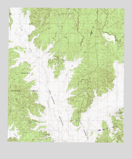
Buck Bay, TX USGS Topographic Map
Click on map above to begin viewing in our Map Viewer.

This topographic map contains these locations and features:
Feature Name Type Latitude Longitude GNIS ID View Map
Ayish BayouStreamN31.1260°W94.0619°1381348View Map
Bayou Boat LaunchLocaleN31.1291°W94.1182°1383661View Map
Big Flat BranchStreamN31.2007°W94.0882°1381426View Map
Blackland CemeteryCemeteryN31.2481°W94.0216°1381453View Map
Boggy BranchStreamN31.1363°W94.0710°1381475View Map
Boggy BranchStreamN31.2060°W94.0941°1381476View Map
Briar BranchStreamN31.2310°W94.1074°1381509View Map
Buck BayBayN31.1907°W94.0619°1383659View Map
Buck BranchStreamN31.1963°W94.0602°1381543View Map
Caney CreekStreamN31.2196°W94.1096°1381579View Map
Couchatana CreekStreamN31.2196°W94.1096°1383072View Map
Easley CreekStreamN31.2135°W94.0060°1381812View Map
Hines CemeteryCemeteryN31.2466°W94.0241°1382004View Map
Huckleberry CreekStreamN31.2480°W94.0519°1382041View Map
Indian Camp BranchStreamN31.1707°W94.0680°1382057View Map
Lakey CemeteryCemeteryN31.1849°W94.0657°1382116View Map
Lakey CemeteryCemeteryN31.2355°W94.1007°1382117View Map
Lane CreekStreamN31.1930°W94.1246°1382122View Map
Little CreekStreamN31.1507°W94.0232°1382170View Map
Little Flat BranchStreamN31.2169°W94.1085°1382175View Map
Massey-Good BranchStreamN31.1616°W94.0260°1382240View Map
McKim CreekStreamN31.1688°W94.0149°1382267View Map
Mill CreekStreamN31.1441°W94.0377°1382297View Map
Mill Creek Park CampgroundLocaleN31.1516°W94.0066°1383658View Map
Miller CemeteryCemeteryN31.1932°W94.0588°1382301View Map
Miller CreekStreamN31.1794°W94.0844°1382304View Map
MillertownLocaleN31.1855°W94.0824°1382307View Map
Mills Creek ParkParkN31.1557°W94.0088°2029758View Map
NeedmorePopulated PlaceN31.1324°W94.0535°1382376View Map
Needmore PointCapeN31.1496°W94.0496°1889706View Map
Owl CreekStreamN31.2155°W94.1091°1382444View Map
Parker CemeteryCemeteryN31.2113°W94.1080°1382457View Map
ParkwayPopulated PlaceN31.2030°W94.0691°1383655View Map
Pigeon Roost CreekStreamN31.1460°W94.0719°1382500View Map
Pomponaugh CreekStreamN31.1813°W94.0074°1382549View Map
Powell ParkLocaleN31.1327°W94.0882°1383657View Map
Powell PointCapeN31.1427°W94.0994°1383662View Map
Powell Town Volunteer Fire DepartmentBuildingN31.1251°W94.0898°2655380View Map
San Augustine ParkParkN31.1985°W94.0763°2029378View Map
San Augustine Park CampgroundLocaleN31.1994°W94.0791°1383654View Map
Sandy CreekStreamN31.1569°W94.0757°1382714View Map
Trout BayouStreamN31.1688°W94.0119°1382880View Map
Williams CemeteryCemeteryN31.1452°W94.0482°1382968View Map

Note: Coordinates in the location and feature list above are referenced to NAD83 datum.


Copyright (C) 2008-2025 Ryan Niemi / Sunset Dynamics ... All Rights Reserved