TopoQuest Logo
Do you find TopoQuest useful?
Help keep TopoQuest running and adding new maps/features by donating!
Bitcoin:  19c7KJd3qBynnjoSw5npx9KScwjBe4ifkT
Litecoin:  LXs6TkuXGGXo1vDsWCkWVdjQX94eUKd6ui
Home View Maps Find Maps Find Places Resources & Links


Bethesda, Tennessee Topographic Map

USGS Map Title: Bethesda, TN
USGS Map MRC: 35086G7
DRG (GeoTIFF) Download: o35086g7.tif


Neighboring USGS Topographic Map Quads:


  Leipers Fork, TN  
35086H8
 

  Franklin, TN  
35086H7
 

  Nolensville, TN  
35086H6
 

  Spring Hill, TN  
35086G8
 

  Bethesda, TN  
35086G7
 

  College Grove, TN  
35086G6
 

  Carters Creek, TN  
35086F8
 

  Rally Hill, TN  
35086F7
 

  Chapel Hill, TN  
35086F6


Map MRC Location:

N36°
W87°
N36°
W86°
H8 H7 H6 H5 H4 H3 H2 H1
G8 G7 G6 G5 G4 G3 G2 G1
F8 F7 F6 F5 F4 F3 F2 F1
E8 E7 E6 E5 E4 E3 E2 E1
D8 D7 D6 D5 D4 D3 D2 D1
C8 C7 C6 C5 C4 C3 C2 C1
B8 B7 B6 B5 B4 B3 B2 B1
A8 A7 A6 A5 A4 A3 A2 A1
N35°
W87°
N35°
W86°

Bethesda, TN USGS 1:24K Topographic Map Preview:
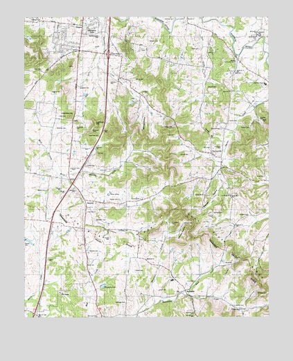
Bethesda, TN USGS Topographic Map
Click on map above to begin viewing in our Map Viewer.

This topographic map contains these locations and features:
Feature Name Type Latitude Longitude GNIS ID View Map
Alexander BranchStreamN35.7553°W86.8092°1275547View Map
Alexander CemeteryCemeteryN35.7562°W86.8233°1304792View Map
Alexander CemeteryCemeteryN35.7906°W86.8383°1321872View Map
Anderson CemeteryCemeteryN35.8289°W86.8586°1321873View Map
Andrews CemeteryCemeteryN35.7984°W86.8331°1275740View Map
Andrews CemeteryCemeteryN35.8028°W86.8489°1275741View Map
Andrews CemeteryCemeteryN35.8326°W86.7547°1275742View Map
Barnett SchoolSchoolN35.8495°W86.8228°1276370View Map
Baugh CemeteryCemeteryN35.8023°W86.8544°1276493View Map
Beal CemeteryCemeteryN35.8520°W86.7675°1276528View Map
Bennett CemeteryCemeteryN35.7937°W86.7786°1321881View Map
Bennett HollowValleyN35.8046°W86.7741°1312462View Map
BethesdaPopulated PlaceN35.7612°W86.7931°1277142View Map
Bethesda - Flat Creek Volunteer Fire Department Station 1 HeadquartersBuildingN35.7656°W86.7989°2653638View Map
Bethesda ChurchChurchN35.7742°W86.8125°1321883View Map
Bethesda Division (historical)CensusN35.7834°W86.7514°1649021View Map
Bethesda Elementary SchoolSchoolN35.7656°W86.7992°1648239View Map
Bethesda United Methodist ChurchChurchN35.7615°W86.7911°1321884View Map
Bishop BranchStreamN35.8725°W86.8042°2745536View Map
Bond CemeteryCemeteryN35.7726°W86.7730°1277931View Map
Bond CreekStreamN35.7595°W86.7914°1277933View Map
Brookhill FarmsLocaleN35.7836°W86.8411°2663277View Map
Buford CemeteryCemeteryN35.8028°W86.8642°1278928View Map
CalliePopulated PlaceN35.8323°W86.8503°1314787View Map
Cedar Hill SchoolSchoolN35.7976°W86.8319°1280074View Map
Chambers HillSummitN35.8337°W86.8522°1280215View Map
Childress CemeteryCemeteryN35.8681°W86.7553°1321904View Map
Christman CemeteryCemeteryN35.7892°W86.8000°1280531View Map
Commissioner District 12CivilN35.8426°W86.7911°2464367View Map
Commissioner District 2CivilN35.7807°W86.7929°2463987View Map
Cool Spring ChurchChurchN35.8009°W86.7700°1306087View Map
Cool Springs CemeteryCemeteryN35.8006°W86.7697°1321906View Map
Core CemeteryCemeteryN35.8339°W86.8575°1321907View Map
Cowles CemeteryCemeteryN35.8131°W86.8436°1321910View Map
Cowles ChapelChurchN35.8070°W86.8522°1306156View Map
Crafton CemeteryCemeteryN35.8287°W86.7600°1321912View Map
Cross KeysLocaleN35.7537°W86.7644°1306193View Map
DouglasPopulated PlaceN35.8715°W86.8456°1314972View Map
Douglas Church (historical)ChurchN35.8717°W86.8456°1321913View Map
Douglas School (historical)SchoolN35.8715°W86.8456°1321914View Map
Duck River RidgeRidgeN35.7870°W86.7806°1269542View Map
Duplex CemeteryCemeteryN35.7503°W86.8386°1321915View Map
Edgmon BranchStreamN35.8559°W86.8372°2745557View Map
Edgmon CemeteryCemeteryN35.8439°W86.8611°1321916View Map
Ellington ParkPopulated PlaceN35.8720°W86.8397°1312929View Map
Elliot CemeteryCemeteryN35.8112°W86.8325°1283665View Map
EpworthPopulated PlaceN35.8737°W86.7917°1315025View Map
Epworth ChurchChurchN35.8742°W86.7919°1321917View Map
Evans CemeteryCemeteryN35.7715°W86.8433°1283900View Map
Fred J Page High SchoolSchoolN35.8473°W86.7506°1300237View Map
Gentry CemeteryCemeteryN35.8317°W86.7705°1321927View Map
Gillespie CemeteryCemeteryN35.8738°W86.8711°1321928View Map
Gooch SchoolSchoolN35.8695°W86.7528°1285609View Map
Goose CreekStreamN35.8640°W86.8353°1285667View Map
Goose Creek SchoolSchoolN35.8609°W86.8467°1285674View Map
Gosey CemeteryCemeteryN35.8617°W86.7855°1285712View Map
Gosey HillSummitN35.8267°W86.7808°1285713View Map
Green Valley EstatesPopulated PlaceN35.8662°W86.8572°1312497View Map
Haleacre CemeteryCemeteryN35.8481°W86.8314°1286525View Map
Halfacre BranchStreamN35.8515°W86.8318°2745559View Map
Halfacre CemeteryCemeteryN35.8742°W86.7983°1321938View Map
Hardeman CemeteryCemeteryN35.8455°W86.8472°1286804View Map
HarpethPopulated PlaceN35.7990°W86.8442°1315196View Map
Harpeth SchoolSchoolN35.8120°W86.8511°1286925View Map
Harpeth Valley ChapelChurchN35.8120°W86.8511°1321940View Map
Hartley CemeteryCemeteryN35.7548°W86.7675°1287052View Map
Heatherwood HillsPopulated PlaceN35.8606°W86.8628°1312502View Map
Holland CemeteryCemeteryN35.7926°W86.7603°1288053View Map
Holt CemeteryCemeteryN35.8187°W86.8381°1321947View Map
Hood CemeteryCemeteryN35.8534°W86.8664°1288226View Map
Hood-Holt CemeteryCemeteryN35.8256°W86.8369°1321950View Map
Hunter CemeteryCemeteryN35.8673°W86.7536°1321953View Map
Interchange 61CrossingN35.8595°W86.8319°1312515View Map
Irvin CemeteryCemeteryN35.7651°W86.7883°1321956View Map
Jackson HollowValleyN35.8150°W86.8226°1312518View Map
Johnson CemeteryCemeteryN35.7892°W86.7939°1321959View Map
Johnson CemeteryCemeteryN35.8462°W86.7764°1321960View Map
Johnson HollowValleyN35.7838°W86.8019°1289613View Map
Jones CemeteryCemeteryN35.8087°W86.7522°1289730View Map
Kennedy CreekStreamN35.8090°W86.8539°1290070View Map
King CemeteryCemeteryN35.8206°W86.7800°1290202View Map
Knott CemeteryCemeteryN35.7612°W86.8064°1290388View Map
Ladd BranchStreamN35.8747°W86.8215°2745546View Map
Little TexasPopulated PlaceN35.8006°W86.7831°1315419View Map
Lookout HillSummitN35.8306°W86.8389°1292033View Map
Lookout Hill BranchStreamN35.8435°W86.8334°2745564View Map
Martin-Hughes BranchStreamN35.8634°W86.8340°2745565View Map
Martin-Hughes CemeteryCemeteryN35.8673°W86.8369°1321969View Map
Meek CemeteryCemeteryN35.8320°W86.7533°1321975View Map
Merritt CemeteryCemeteryN35.8489°W86.8186°1293630View Map
Millview Community CenterBuildingN35.8573°W86.7664°1321978View Map
Mount Carmel ChurchChurchN35.7503°W86.8383°1294585View Map
Mount Carmel SchoolSchoolN35.7512°W86.8381°1294596View Map
New Hope ChurchChurchN35.7937°W86.8431°1295537View Map
PeytonsvillePopulated PlaceN35.8184°W86.7794°1297292View Map
Peytonsville Volunteer Fire DepartmentBuildingN35.8113°W86.7759°2653769View Map
Pointer CemeteryCemeteryN35.7812°W86.8744°1298013View Map
Poteete CemeteryCemeteryN35.7989°W86.8269°1298345View Map
Pratt CreekStreamN35.8475°W86.8387°2745550View Map
Riverbend NurseriesBuildingN35.7825°W86.8511°2663279View Map
Shuemate BranchStreamN35.8542°W86.8373°2745570View Map
Shuemate CemeteryCemeteryN35.8289°W86.8483°1322009View Map
Simmons CemeteryCemeteryN35.8284°W86.7744°1322010View Map
Smithson CemeteryCemeteryN35.7864°W86.8218°1270716View Map
Smithson CemeteryCemeteryN35.8212°W86.7744°1270717View Map
SpringviewPopulated PlaceN35.8709°W86.8586°1312561View Map
Sprott CemeteryCemeteryN35.7695°W86.8186°1303780View Map
Steele CemeteryCemeteryN35.7828°W86.8317°1271304View Map
Stone LakesReservoirN35.8011°W86.8319°1312564View Map
Talley HillSummitN35.8281°W86.8011°1272060View Map
Thomas Church (historical)ChurchN35.8431°W86.7833°1322017View Map
Thompson CemeteryCemeteryN35.7995°W86.8158°1272519View Map
Thompson LakeReservoirN35.7631°W86.8346°1304084View Map
Thompson Lake DamDamN35.7635°W86.8351°1307153View Map
West Fork Aenon CreekStreamN35.7556°W86.8747°1274154View Map
Westwood SchoolSchoolN35.8448°W86.7683°1274266View Map
Williams CemeteryCemeteryN35.7598°W86.7508°1274653View Map
Williams CemeteryCemeteryN35.7778°W86.8419°1322034View Map
Williams CemeteryCemeteryN35.8651°W86.8111°1322035View Map

Note: Coordinates in the location and feature list above are referenced to NAD83 datum.


Copyright (C) 2008-2024 Ryan Niemi / Sunset Dynamics ... All Rights Reserved