TopoQuest Logo
Do you find TopoQuest useful?
Help keep TopoQuest running and adding new maps/features by donating!
Bitcoin:  19c7KJd3qBynnjoSw5npx9KScwjBe4ifkT
Litecoin:  LXs6TkuXGGXo1vDsWCkWVdjQX94eUKd6ui
Home View Maps Find Maps Find Places Resources & Links


Spring Hill, Tennessee Topographic Map

USGS Map Title: Spring Hill, TN
USGS Map MRC: 35086G8
DRG (GeoTIFF) Download: o35086g8.tif


Neighboring USGS Topographic Map Quads:


  Fairview, TN  
35087H1
 

  Leipers Fork, TN  
35086H8
 

  Franklin, TN  
35086H7
 

  Theta, TN  
35087G1
 

  Spring Hill, TN  
35086G8
 

  Bethesda, TN  
35086G7
 

  Godwin, TN  
35087F1
 

  Carters Creek, TN  
35086F8
 

  Rally Hill, TN  
35086F7


Map MRC Location:

N36°
W87°
N36°
W86°
H8 H7 H6 H5 H4 H3 H2 H1
G8 G7 G6 G5 G4 G3 G2 G1
F8 F7 F6 F5 F4 F3 F2 F1
E8 E7 E6 E5 E4 E3 E2 E1
D8 D7 D6 D5 D4 D3 D2 D1
C8 C7 C6 C5 C4 C3 C2 C1
B8 B7 B6 B5 B4 B3 B2 B1
A8 A7 A6 A5 A4 A3 A2 A1
N35°
W87°
N35°
W86°

Spring Hill, TN USGS 1:24K Topographic Map Preview:
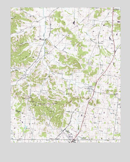
Spring Hill, TN USGS Topographic Map
Click on map above to begin viewing in our Map Viewer.

This topographic map contains these locations and features:
Feature Name Type Latitude Longitude GNIS ID View Map
Alexander CemeteryCemeteryN35.7534°W86.9906°1275554View Map
Barker CemeteryCemeteryN35.8145°W86.9408°1276308View Map
Bear CreekStreamN35.8590°W86.9600°1276593View Map
Bethel Church (historical)ChurchN35.8453°W86.8897°1321882View Map
BurwoodPopulated PlaceN35.8126°W86.9833°1279138View Map
Calvary ChurchChurchN35.7792°W86.9556°1279347View Map
Caperton CemeteryCemeteryN35.7537°W86.8950°1321899View Map
Carter CemeteryCemeteryN35.7853°W86.9625°1279788View Map
Cayce BranchStreamN35.8165°W86.9553°1279984View Map
Cayce SpringSpringN35.8112°W86.9574°1305749View Map
Cheatham (historical)Populated PlaceN35.8156°W86.8994°1312471View Map
Commissioner District 3CivilN35.7662°W86.8995°2464001View Map
Connection Hill ChurchChurchN35.7940°W86.8808°1281090View Map
Country Haven EstatesPopulated PlaceN35.7995°W86.9128°1312477View Map
Doc Jones HollowValleyN35.8411°W86.9681°1282541View Map
Dodson CemeteryCemeteryN35.7812°W86.9775°1282564View Map
Dogwood HollowValleyN35.8429°W86.9788°1282610View Map
Evergreen CemeteryCemeteryN35.7945°W86.9364°1283926View Map
Evergreen ChurchChurchN35.8001°W86.9350°1283929View Map
Fedco SidingLocaleN35.8217°W86.8978°1284185View Map
Forest Hill Church (historical)ChurchN35.8628°W86.9547°1321921View Map
Forest Hill SchoolSchoolN35.8642°W86.9539°1284595View Map
Gary LakeLakeN35.7772°W86.8862°1285220View Map
Harrison CemeteryCemeteryN35.8576°W86.8856°1287014View Map
Homestead Manor Plantation (historical)LocaleN35.8062°W86.9044°1321949View Map
Johnson CemeteryCemeteryN35.8192°W86.9947°1289555View Map
Johnson HollowValleyN35.8131°W86.9808°1289630View Map
Jones CemeteryCemeteryN35.8292°W86.9728°1289731View Map
Kelly BranchStreamN35.8620°W86.9242°1313665View Map
Laura LakeReservoirN35.7644°W86.9831°1306669View Map
Laura Lake DamDamN35.7627°W86.9837°1307154View Map
Laurel Hill Plantation (historical)LocaleN35.8367°W86.8847°1321964View Map
Lavender CemeteryCemeteryN35.7989°W86.9061°1290770View Map
Lawrence CemeteryCemeteryN35.7912°W86.9842°1645131View Map
Lawrence Grove ChurchChurchN35.7915°W86.9794°1290787View Map
Lea Farm Plantation (historical)LocaleN35.8176°W86.8906°1321965View Map
Leipers Fork ChurchChurchN35.8451°W86.9611°1291009View Map
Little Carters CreekStreamN35.7537°W86.9975°1291418View Map
Martin CemeteryCemeteryN35.7987°W86.9633°1292803View Map
Mayberry (historical)Populated PlaceN35.8626°W86.8842°1312531View Map
McCormack CrossingLocaleN35.7531°W86.9506°1315483View Map
McKee CemeteryCemeteryN35.8339°W86.9675°1293054View Map
McMeen BranchStreamN35.7537°W86.9764°1269281View Map
Morganville (historical)Populated PlaceN35.7592°W86.9978°1313513View Map
Mount Lavergne ChurchChurchN35.7884°W86.9736°1294657View Map
Mount Lavergne SchoolSchoolN35.7915°W86.9756°1294658View Map
Murfree CemeteryCemeteryN35.8328°W86.9581°1295103View Map
New TownPopulated PlaceN35.7537°W86.9172°1295656View Map
New Town CemeteryCemeteryN35.7539°W86.9153°1645133View Map
Nicholson CemeteryCemeteryN35.7678°W86.9042°1295733View Map
Nicholson CemeteryCemeteryN35.7698°W86.9000°1295734View Map
North CemeteryCemeteryN35.8453°W86.9033°1295848View Map
Patton CemeteryCemeteryN35.8117°W86.9253°1296977View Map
Peckerwood HollowValleyN35.8596°W86.9665°1297099View Map
Perkins ChurchChurchN35.8451°W86.9692°1297191View Map
Pleasantdale Church (historical)ChurchN35.8409°W86.9631°1321993View Map
Pointer CemeteryCemeteryN35.7676°W86.8797°1321994View Map
Rattlesnake BranchStreamN35.8473°W86.9614°1298941View Map
Ridley HollowValleyN35.8312°W86.9608°1299420View Map
Roderick Plantation (historical)LocaleN35.8067°W86.8986°1321999View Map
Russel White DamDamN35.8617°W86.8783°1302179View Map
Russel White LakeReservoirN35.8617°W86.8770°1302178View Map
Satterfield (historical)Populated PlaceN35.7576°W86.9842°1313524View Map
Sherwood MansionBuildingN35.7823°W86.9114°1322004View Map
Spring Green FarmLocaleN35.7840°W86.9167°1322014View Map
Spring HillPopulated PlaceN35.7512°W86.9300°1303764View Map
Spring Hill Elementary SchoolSchoolN35.7520°W86.9269°1324902View Map
Spring Hill Fire Department Station 1BuildingN35.7533°W86.9418°2653706View Map
Spring Hill Fire Department Station 3BuildingN35.7746°W86.9093°2653934View Map
Spring Hill High SchoolSchoolN35.7523°W86.9272°1324904View Map
Spring Hill Post OfficePost OfficeN35.7524°W86.9420°1652350View Map
Spring Hill StationLocaleN35.7612°W86.9400°1646549View Map
Sugar RidgeRidgeN35.7837°W86.9614°1271701View Map
Swanson HollowValleyN35.7953°W86.9600°1271954View Map
SycamorePopulated PlaceN35.8170°W86.9975°1271997View Map
Sycamore CreeStreamN35.8306°W86.9617°1312568View Map
Thompson's StationPopulated PlaceN35.8020°W86.9114°1652469View Map
Thompsons Station Post OfficePost OfficeN35.7967°W86.9075°1651836View Map
Todd LakeReservoirN35.8465°W86.8871°1302169View Map
Todd Lake DamDamN35.8451°W86.8867°1302168View Map
Town of Thompson's StationCivilN35.8090°W86.8999°2406730View Map
Wade CemeteryCemeteryN35.7589°W86.8797°1273517View Map
Walton CemeteryCemeteryN35.7628°W86.9019°1273754View Map
Warioto FarmsLocaleN35.8589°W86.9069°2662958View Map
Wells CemeteryCemeteryN35.7535°W86.9030°2742665View Map
Wells CemeteryCemeteryN35.7535°W86.9030°1322031View Map
West HarpethPopulated PlaceN35.8426°W86.9000°1314488View Map
West Harpeth ChurchChurchN35.8731°W86.8831°1304472View Map
West Harpeth SchoolSchoolN35.8442°W86.8911°1274198View Map
West Prong Murfrees ForkStreamN35.8312°W86.9614°1304486View Map
Westend Church (historical)ChurchN35.7978°W86.9778°1322032View Map
Wilkes (historical)Populated PlaceN35.7784°W86.9292°1652062View Map

Note: Coordinates in the location and feature list above are referenced to NAD83 datum.


Copyright (C) 2008-2025 Ryan Niemi / Sunset Dynamics ... All Rights Reserved