TopoQuest Logo
Do you find TopoQuest useful?
Help keep TopoQuest running and adding new maps/features by donating!
Bitcoin:  19c7KJd3qBynnjoSw5npx9KScwjBe4ifkT
Litecoin:  LXs6TkuXGGXo1vDsWCkWVdjQX94eUKd6ui
Home View Maps Find Maps Find Places Resources & Links


Pitchpine Mountain, Colorado Topographic Map

USGS Map Title: Pitchpine Mountain, CO
USGS Map MRC: 40106F5
DRG (GeoTIFF) Download: o40106f5.tif


Neighboring USGS Topographic Map Quads:


  Mount Zirkel, CO  
40106G6
 

  Boettcher Lake, CO  
40106G5
 

  Lake John, CO  
40106G4
 

  Mount Ethel, CO  
40106F6
 

  Pitchpine Mountain, CO  
40106F5
 

  Delaney Butte, CO  
40106F4
 

  Buffalo Pass, CO  
40106E6
 

  Teal Lake, CO  
40106E5
 

  Coalmont, CO  
40106E4


Map MRC Location:

N41°
W107°
N41°
W106°
H8 H7 H6 H5 H4 H3 H2 H1
G8 G7 G6 G5 G4 G3 G2 G1
F8 F7 F6 F5 F4 F3 F2 F1
E8 E7 E6 E5 E4 E3 E2 E1
D8 D7 D6 D5 D4 D3 D2 D1
C8 C7 C6 C5 C4 C3 C2 C1
B8 B7 B6 B5 B4 B3 B2 B1
A8 A7 A6 A5 A4 A3 A2 A1
N40°
W107°
N40°
W106°

Pitchpine Mountain, CO USGS 1:24K Topographic Map Preview:
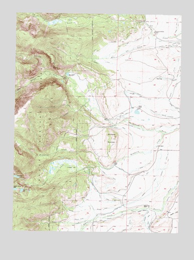
Pitchpine Mountain, CO USGS Topographic Map
Click on map above to begin viewing in our Map Viewer.

This topographic map contains these locations and features:
Feature Name Type Latitude Longitude GNIS ID View Map
Aspin DitchCanalN40.6390°W106.5842°2711023View Map
Beaver DitchCanalN40.6600°W106.5423°172353View Map
Brands RanchLocaleN40.6961°W106.5317°172341View Map
Briggs and Bohn DitchCanalN40.7472°W106.5042°201929View Map
Butler CreekStreamN40.6314°W106.5673°172365View Map
Butler DitchCanalN40.6315°W106.5771°172360View Map
Butler Ditch Number 2CanalN40.6385°W106.5550°2711392View Map
Butler Ditch Number 3CanalN40.6366°W106.5767°2711393View Map
Butler Ditch Number 4CanalN40.6305°W106.5645°172359View Map
Butte CreekStreamN40.6855°W106.5000°196656View Map
Canon DitchCanalN40.6722°W106.5645°172351View Map
Carlstrom Brothers RanchLocaleN40.7403°W106.5198°172344View Map
Ceanothuse LakeLakeN40.6560°W106.6233°172338View Map
Crystal MineMineN40.6822°W106.5909°1683305View Map
Dora DitchCanalN40.6369°W106.5181°2711866View Map
Earnest DitchCanalN40.6333°W106.5498°172358View Map
Emigh RanchLocaleN40.6403°W106.5242°172334View Map
Erika DitchCanalN40.7437°W106.5247°2712026View Map
Eriki DitchCanalN40.7461°W106.5256°172345View Map
Heineman DitchCanalN40.6861°W106.5395°172349View Map
Higho DitchCanalN40.6861°W106.5145°202047View Map
Hillside DitchCanalN40.7305°W106.5589°172347View Map
Hodgson DitchCanalN40.6350°W106.5256°172354View Map
Irvine RanchLocaleN40.6750°W106.5173°172335View Map
Japanese Davidson DitchCanalN40.7319°W106.5034°202048View Map
Joe MineMineN40.6833°W106.5923°1683307View Map
Lillie DitchCanalN40.7361°W106.5200°202050View Map
Livingston ParkFlatN40.6616°W106.5811°172339View Map
Lone Pine DitchCanalN40.7361°W106.5325°172346View Map
Lower Rainbow LakeLakeN40.6481°W106.6194°172337View Map
Manville Ditch Number 2CanalN40.6289°W106.5248°172368View Map
Middle Rainbow LakeLakeN40.6488°W106.6243°202040View Map
Mitchell DitchCanalN40.6444°W106.5284°172362View Map
Norrell DitchCanalN40.7116°W106.5756°172340View Map
Norris CreekStreamN40.6628°W106.5598°172330View Map
Norris DitchCanalN40.6555°W106.5506°172357View Map
Norris RanchLocaleN40.6633°W106.5498°172336View Map
Open A Diamond DitchCanalN40.6555°W106.5367°172350View Map
Pearl DitchCanalN40.6972°W106.5728°172352View Map
Pedad MineMineN40.7216°W106.5973°1683306View Map
Pitchpine MountainSummitN40.6783°W106.5509°172342View Map
Raspberry CreekStreamN40.6819°W106.5131°172367View Map
Red CanyonValleyN40.7150°W106.5990°172331View Map
Red Canyon ReservoirReservoirN40.7152°W106.5861°172343View Map
Roaring DitchCanalN40.6408°W106.5423°172361View Map
South Fork Beaver CreekStreamN40.6378°W106.5159°172355View Map
Spar MineMineN40.7039°W106.6034°1683308View Map
Spring CreekStreamN40.6941°W106.5806°172364View Map
Spring Gulch DitchCanalN40.7194°W106.5014°202046View Map
Sunday CreekStreamN40.6989°W106.5720°172363View Map
Sunday Creek DitchCanalN40.6841°W106.5423°172356View Map
Timber DitchCanalN40.7222°W106.5667°172348View Map
Wolfer DitchCanalN40.7080°W106.5367°202042View Map
Wolfer DitchCanalN40.6922°W106.5117°202043View Map

Note: Coordinates in the location and feature list above are referenced to NAD83 datum.


Copyright (C) 2008-2025 Ryan Niemi / Sunset Dynamics ... All Rights Reserved