TopoQuest Logo
Do you find TopoQuest useful?
Help keep TopoQuest running and adding new maps/features by donating!
Bitcoin:  19c7KJd3qBynnjoSw5npx9KScwjBe4ifkT
Litecoin:  LXs6TkuXGGXo1vDsWCkWVdjQX94eUKd6ui
Home View Maps Find Maps Find Places Resources & Links


Boettcher Lake, Colorado Topographic Map

USGS Map Title: Boettcher Lake, CO
USGS Map MRC: 40106G5
DRG (GeoTIFF) Download: o40106g5.tif


Neighboring USGS Topographic Map Quads:


  Davis Peak, CO  
40106H6
 

  Pearl, CO  
40106H5
 

  Independence Mountain, CO  
40106H4
 

  Mount Zirkel, CO  
40106G6
 

  Boettcher Lake, CO  
40106G5
 

  Lake John, CO  
40106G4
 

  Mount Ethel, CO  
40106F6
 

  Pitchpine Mountain, CO  
40106F5
 

  Delaney Butte, CO  
40106F4


Map MRC Location:

N41°
W107°
N41°
W106°
H8 H7 H6 H5 H4 H3 H2 H1
G8 G7 G6 G5 G4 G3 G2 G1
F8 F7 F6 F5 F4 F3 F2 F1
E8 E7 E6 E5 E4 E3 E2 E1
D8 D7 D6 D5 D4 D3 D2 D1
C8 C7 C6 C5 C4 C3 C2 C1
B8 B7 B6 B5 B4 B3 B2 B1
A8 A7 A6 A5 A4 A3 A2 A1
N40°
W107°
N40°
W106°

Boettcher Lake, CO USGS 1:24K Topographic Map Preview:
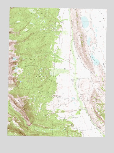
Boettcher Lake, CO USGS Topographic Map
Click on map above to begin viewing in our Map Viewer.

This topographic map contains these locations and features:
Feature Name Type Latitude Longitude GNIS ID View Map
Bear CreekStreamN40.7783°W106.5289°170430View Map
Bear Creek DitchCanalN40.7711°W106.5423°170386View Map
Bear Creek MineMineN40.7608°W106.5986°1683295View Map
Bear MountainSummitN40.7828°W106.6117°170373View Map
Blue LakeLakeN40.8248°W106.6184°170400View Map
Blue Lake TrailTrailN40.8278°W106.5923°170399View Map
Boettcher LakeLakeN40.8245°W106.5146°170398View Map
Boettcher RanchLocaleN40.8069°W106.5353°170392View Map
Boulder DitchCanalN40.7528°W106.5281°201928View Map
Brands RanchLocaleN40.7705°W106.5006°170363View Map
Brands ReservoirReservoirN40.7750°W106.5020°170364View Map
Brown CreekStreamN40.7961°W106.5434°170376View Map
Brown HomesteadLocaleN40.7894°W106.5623°170377View Map
Dead Horse DrawValleyN40.8652°W106.5058°170012View Map
Dry RunStreamN40.7661°W106.5189°170382View Map
Dry Run DitchCanalN40.7578°W106.5367°170385View Map
Eber DitchCanalN40.7861°W106.5556°170378View Map
Elk ParkFlatN40.8166°W106.5895°172531View Map
First Run DitchCanalN40.8150°W106.5492°170394View Map
Fliniau HomesteadLocaleN40.7611°W106.5439°170383View Map
Fliniau RanchLocaleN40.7591°W106.5081°170384View Map
Fort BoettcherPopulated PlaceN40.8044°W106.5439°170393View Map
Fryingpan TrailTrailN40.8500°W106.6089°201933View Map
Goose CreekStreamN40.8700°W106.5486°169952View Map
Grizzly Helena TrailTrailN40.8250°W106.5853°169954View Map
Hard to Find DitchCanalN40.8237°W106.5585°2712504View Map
Haworth Ditch Number 1CanalN40.7653°W106.5464°170388View Map
Haworth Ditch Number 2CanalN40.7689°W106.5334°170387View Map
Hill CreekStreamN40.8180°W106.5400°170432View Map
Hill Ditch Number 2CanalN40.8736°W106.5103°169458View Map
Lake CreekStreamN40.8105°W106.5403°170395View Map
Lake Creek DitchCanalN40.7816°W106.5506°170381View Map
Lawrence DrawValleyN40.8183°W106.5018°169990View Map
Lookout DitchCanalN40.7933°W106.5811°170375View Map
Mable Dow DitchStreamN40.8091°W106.5664°196702View Map
Marble Dow DitchCanalN40.8050°W106.5617°170371View Map
Monahan Coal MineLocaleN40.7911°W106.5328°170391View Map
Monahan CreekStreamN40.7769°W106.5642°170380View Map
Monahan HomesteadLocaleN40.7761°W106.5314°170389View Map
Monahan MineMineN40.7911°W106.5325°1683294View Map
North Fork DitchCanalN40.7986°W106.5384°170390View Map
Shafer CreekStreamN40.8611°W106.5464°170427View Map
Shafer DitchCanalN40.8566°W106.5581°170403View Map
Shafer RanchLocaleN40.8614°W106.5511°170404View Map
Sheep MountainSummitN40.7714°W106.5081°201931View Map
Stormy DitchCanalN40.8361°W106.5617°170402View Map
Sunrise DitchCanalN40.7878°W106.5617°170379View Map
Twin LakeLakeN40.8127°W106.6158°170397View Map
Twin Lake TrailTrailN40.8186°W106.5992°170396View Map
Ute CreekStreamN40.8097°W106.5386°170431View Map
Ute LakeLakeN40.8028°W106.6098°170372View Map
Ute Pass TrailTrailN40.7953°W106.6006°201934View Map
West Boettcher DitchCanalN40.8022°W106.5673°170374View Map
Zirkel DitchCanalN40.8264°W106.5520°170401View Map

Note: Coordinates in the location and feature list above are referenced to NAD83 datum.


Copyright (C) 2008-2025 Ryan Niemi / Sunset Dynamics ... All Rights Reserved