TopoQuest Logo
Do you find TopoQuest useful?
Help keep TopoQuest running and adding new maps/features by donating!
Bitcoin:  19c7KJd3qBynnjoSw5npx9KScwjBe4ifkT
Litecoin:  LXs6TkuXGGXo1vDsWCkWVdjQX94eUKd6ui
Home View Maps Find Maps Find Places Resources & Links


Pittsburg, Oklahoma Topographic Map

USGS Map Title: Pittsburg, OK
USGS Map MRC: 34095F7
DRG (GeoTIFF) Download: o34095f7.tif


Neighboring USGS Topographic Map Quads:


  McAlester SW, OK  
34095G8
 

  Savanna, OK  
34095G7
 

  Hartshorne SW, OK  
34095G6
 

  Kiowa, OK  
34095F8
 

  Pittsburg, OK  
34095F7
 

  Ti, OK  
34095F6
 

  Limestone Gap, OK  
34095E8
 

  Redden, OK  
34095E7
 

  Daisy, OK  
34095E6


Map MRC Location:

N35°
W96°
N35°
W95°
H8 H7 H6 H5 H4 H3 H2 H1
G8 G7 G6 G5 G4 G3 G2 G1
F8 F7 F6 F5 F4 F3 F2 F1
E8 E7 E6 E5 E4 E3 E2 E1
D8 D7 D6 D5 D4 D3 D2 D1
C8 C7 C6 C5 C4 C3 C2 C1
B8 B7 B6 B5 B4 B3 B2 B1
A8 A7 A6 A5 A4 A3 A2 A1
N34°
W96°
N34°
W95°

Pittsburg, OK USGS 1:24K Topographic Map Preview:
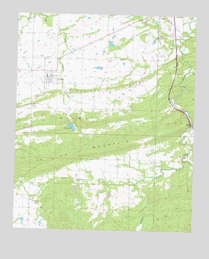
Pittsburg, OK USGS Topographic Map
Click on map above to begin viewing in our Map Viewer.

This topographic map contains these locations and features:
Feature Name Type Latitude Longitude GNIS ID View Map
Bill Hopper Lake DamDamN34.7184°W95.8186°1755533View Map
Brush NarrowsGapN34.6870°W95.7522°1090563View Map
Brushy Peaceable Creek Site 16 DamDamN34.6468°W95.8086°1752307View Map
Brushy Peaceable Creek Site 17 DamDamN34.6501°W95.8319°1752309View Map
Brushy Peaceable Creek Site 17 ReservoirReservoirN34.6477°W95.8325°1752310View Map
Burshy Peaceable Creek Site 16 ReservoirReservoirN34.6454°W95.8088°1752308View Map
Calvary CemeteryCemeteryN34.7245°W95.8564°1090815View Map
Chippewa CreekStreamN34.6520°W95.7908°1091309View Map
Elm CreekStreamN34.6868°W95.7517°1092563View Map
Hopper LakeReservoirN34.7193°W95.8189°1755534View Map
Limestone RidgeRidgeN34.7134°W95.7828°1094655View Map
Modisette CreekStreamN34.7182°W95.7542°1095462View Map
Oknoname 121001 DamDamN34.6501°W95.7553°1755535View Map
Oknoname 121001 ReservoirReservoirN34.6501°W95.7553°1755536View Map
PittsburgPopulated PlaceN34.7132°W95.8500°1096696View Map
Pittsburg Area Volunteer Fire DepartmentBuildingN34.7144°W95.8496°2656984View Map
Pittsburg CemeteryCemeteryN34.7245°W95.8550°1096697View Map
Pittsburg DamDamN34.6868°W95.8353°1751832View Map
Pittsburg Elementary SchoolSchoolN34.7144°W95.8542°1803467View Map
Pittsburg High SchoolSchoolN34.7144°W95.8542°1790434View Map
Pittsburg LakeReservoirN34.6845°W95.8360°1096698View Map
Pleasant Valley CemeteryCemeteryN34.6970°W95.8639°1096750View Map
Rock CreekStreamN34.6670°W95.7580°1097308View Map
Storrie LakeReservoirN34.7331°W95.8097°1098571View Map
Storrie Lake DamDamN34.7301°W95.8086°1755525View Map
Town of PittsburgCivilN34.7116°W95.8502°2413139View Map
Union ChapelChurchN34.6407°W95.8586°1099156View Map
Union Chapel CemeteryCemeteryN34.6403°W95.8597°2712535View Map
Union Chapel Fire DepartmentBuildingN34.6517°W95.8641°2657300View Map
Wildhorse CreekStreamN34.7320°W95.7614°1099790View Map

Note: Coordinates in the location and feature list above are referenced to NAD83 datum.


Copyright (C) 2008-2025 Ryan Niemi / Sunset Dynamics ... All Rights Reserved