TopoQuest Logo
Do you find TopoQuest useful?
Help keep TopoQuest running and adding new maps/features by donating!
Bitcoin:  19c7KJd3qBynnjoSw5npx9KScwjBe4ifkT
Litecoin:  LXs6TkuXGGXo1vDsWCkWVdjQX94eUKd6ui
Home View Maps Find Maps Find Places Resources & Links


Pittstown, New Jersey Topographic Map

USGS Map Title: Pittstown, NJ
USGS Map MRC: 40074E8
DRG (GeoTIFF) Download: o40074e8.tif


Neighboring USGS Topographic Map Quads:


  Bloomsbury, NJ  
40075F1
 

  High Bridge, NJ  
40074F8
 

  Califon, NJ  
40074F7
 

  Frenchtown, NJ  
40075E1
 

  Pittstown, NJ  
40074E8
 

  Flemington, NJ  
40074E7
 

  Lumberville, PA  
40075D1
 

  Stockton, NJ  
40074D8
 

  Hopewell, NJ  
40074D7


Map MRC Location:

N41°
W75°
N41°
W74°
H8 H7 H6 H5 H4 H3 H2 H1
G8 G7 G6 G5 G4 G3 G2 G1
F8 F7 F6 F5 F4 F3 F2 F1
E8 E7 E6 E5 E4 E3 E2 E1
D8 D7 D6 D5 D4 D3 D2 D1
C8 C7 C6 C5 C4 C3 C2 C1
B8 B7 B6 B5 B4 B3 B2 B1
A8 A7 A6 A5 A4 A3 A2 A1
N40°
W75°
N40°
W74°

Pittstown, NJ USGS 1:24K Topographic Map Preview:
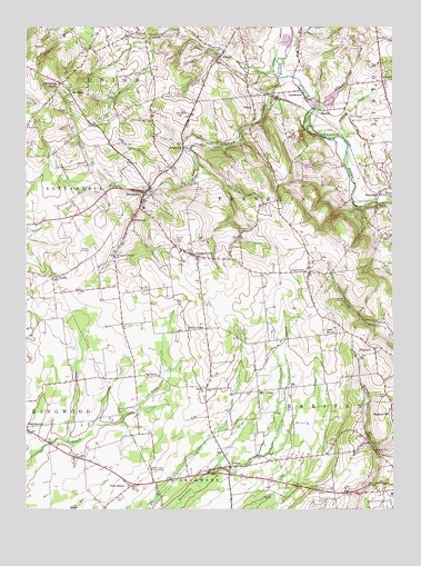
Pittstown, NJ USGS Topographic Map
Click on map above to begin viewing in our Map Viewer.

This topographic map contains these locations and features:
Feature Name Type Latitude Longitude GNIS ID View Map
Allens CornerPopulated PlaceN40.5468°W74.9385°874298View Map
AllertonPopulated PlaceN40.6112°W74.8785°874303View Map
Allerton CreekStreamN40.5961°W74.8919°874304View Map
Allerton Methodist Church YardCemeteryN40.6115°W74.8799°2043920View Map
Allerton United Methodist ChurchChurchN40.6112°W74.8807°2043935View Map
Alvater CornerPopulated PlaceN40.5659°W74.9699°874328View Map
Atlantic Ambulance CorpsBuildingN40.5783°W74.9598°2660069View Map
Augie's Tree FarmLocaleN40.5331°W74.9392°2678224View Map
Bethlehem CemeteryCemeteryN40.6187°W74.9343°874728View Map
Bethlehem ChurchChurchN40.6182°W74.9352°2042700View Map
Bradford Field (historical)AirportN40.5002°W74.9564°884741View Map
Cakepoulin CreekStreamN40.6124°W74.9106°875083View Map
Calvary ChurchChurchN40.5315°W74.9388°875097View Map
Capoolong Wildlife Management AreaParkN40.5945°W74.9329°883054View Map
CherryvillePopulated PlaceN40.5612°W74.9032°875399View Map
Cherryville Baptist CemeteryCemeteryN40.5634°W74.9041°2043921View Map
Cherryville Baptist ChurchChurchN40.5629°W74.9038°2043936View Map
Clinton Township Police DepartmentBuildingN40.6226°W74.8795°2730930View Map
Copper Penny (historical)AirportN40.5570°W74.8791°882341View Map
Cramers CreekStreamN40.6033°W74.9017°875695View Map
CrotonPopulated PlaceN40.5109°W74.9302°875751View Map
Echo Lake (historical)LakeN40.5815°W74.8752°2042706View Map
Formica (historical)AirportN40.5390°W74.9996°882343View Map
Franklin Township Elementary SchoolSchoolN40.5670°W74.9474°2042677View Map
Franklin Township Police Department PittstownBuildingN40.6064°W74.9235°2730579View Map
Gary CornerPopulated PlaceN40.5307°W74.9207°876568View Map
GrandinPopulated PlaceN40.6176°W74.9338°876705View Map
HamdenPopulated PlaceN40.6034°W74.9004°876902View Map
Hunterdon CountyCivilN40.5673°W74.9122°882228View Map
Independence School (historical)SchoolN40.5107°W74.9793°2042701View Map
JutlandPopulated PlaceN40.6229°W74.9643°877508View Map
Jutland LakeReservoirN40.6245°W74.9535°884028View Map
Jutland School (historical)SchoolN40.6220°W74.9652°2042702View Map
KingtownPopulated PlaceN40.5937°W74.9463°877583View Map
KlinesvillePopulated PlaceN40.5415°W74.8810°877603View Map
Klinesville School (historical)SchoolN40.5348°W74.8804°2042703View Map
LansdownePopulated PlaceN40.6084°W74.9063°877671View Map
LittletownPopulated PlaceN40.5751°W74.9635°877873View Map
Locust Grove CemeteryCemeteryN40.5695°W74.9491°877886View Map
Mechlings CornerPopulated PlaceN40.6104°W74.9879°878246View Map
Mock Airport (historical)AirportN40.5334°W74.9157°884905View Map
Mount SalemPopulated PlaceN40.6082°W74.9846°878588View Map
Mount Salem CemeteryCemeteryN40.6056°W74.9832°2042699View Map
New Jersey State Police Troop C Kingwood StationBuildingN40.5197°W74.9962°2731039View Map
Oak GrovePopulated PlaceN40.5343°W74.9543°878902View Map
Oakgrove Grange HallBuildingN40.5545°W74.9677°2042698View Map
Patrick McGaheran Elementary SchoolSchoolN40.6100°W74.8758°2373617View Map
Peaceful Valley OrchardsLocaleN40.6081°W74.9425°2516011View Map
PittstownPopulated PlaceN40.5820°W74.9591°879337View Map
Point BreezePopulated PlaceN40.5062°W74.9643°879391View Map
QuakertownPopulated PlaceN40.5657°W74.9416°879564View Map
Quakertown Fire Company Station 91BuildingN40.5761°W74.9570°2614322View Map
Quakertown United Methodist ChurchChurchN40.5648°W74.9418°2043937View Map
Quakertown Volunteer Emergency Medical ServicesBuildingN40.5854°W74.9552°2660062View Map
Robert Hunter Elementary SchoolSchoolN40.5040°W74.8755°2042682View Map
Saint Thomas Episcopal ChurchChurchN40.5607°W74.9891°880214View Map
Saint Thomas Episcopal Church YardCemeteryN40.5606°W74.9893°2043925View Map
SidneyPopulated PlaceN40.6043°W74.9221°880591View Map
Sky Manor AirportAirportN40.5664°W74.9783°884894View Map
Summit School (historical)SchoolN40.5143°W74.8996°2042704View Map
SunnysidePopulated PlaceN40.5818°W74.8796°881002View Map
Teeny Weeny Acres Airport (historical)AirportN40.5168°W74.8824°884740View Map
Thachers HillPopulated PlaceN40.5259°W74.8779°881142View Map
Township of FranklinCivilN40.5662°W74.9351°882184View Map
Township of RaritanCivilN40.5162°W74.8980°882179View Map
WCVH-FM (Flemington)TowerN40.5570°W74.9046°884610View Map
WDVR-FM (Delaware Township)TowerN40.5104°W74.9577°884603View Map
WJHR-AM (Flemington)TowerN40.5051°W74.9766°884573View Map

Note: Coordinates in the location and feature list above are referenced to NAD83 datum.


Copyright (C) 2008-2024 Ryan Niemi / Sunset Dynamics ... All Rights Reserved