TopoQuest Logo
Do you find TopoQuest useful?
Help keep TopoQuest running and adding new maps/features by donating!
Bitcoin:  19c7KJd3qBynnjoSw5npx9KScwjBe4ifkT
Litecoin:  LXs6TkuXGGXo1vDsWCkWVdjQX94eUKd6ui
Home View Maps Find Maps Find Places Resources & Links


Piute Point, Arizona Topographic Map

USGS Map Title: Piute Point, AZ
USGS Map MRC: 36112A3
DRG (GeoTIFF) Download: o36112a3.tif


Neighboring USGS Topographic Map Quads:


  Explorers Monument, AZ  
36112B4
 

  Havasupai Point, AZ  
36112B3
 

  Shiva Temple, AZ  
36112B2
 

  Chamisa Tank, AZ  
36112A4
 

  Piute Point, AZ  
36112A3
 

  Grand Canyon, AZ  
36112A2
 

  Box K Ranch, AZ  
35112H4
 

  Metzger Tank, AZ  
35112H3
 

  Tusayan West, AZ  
35112H2


Map MRC Location:

N37°
W113°
N37°
W112°
H8 H7 H6 H5 H4 H3 H2 H1
G8 G7 G6 G5 G4 G3 G2 G1
F8 F7 F6 F5 F4 F3 F2 F1
E8 E7 E6 E5 E4 E3 E2 E1
D8 D7 D6 D5 D4 D3 D2 D1
C8 C7 C6 C5 C4 C3 C2 C1
B8 B7 B6 B5 B4 B3 B2 B1
A8 A7 A6 A5 A4 A3 A2 A1
N36°
W113°
N36°
W112°

Piute Point, AZ USGS 1:24K Topographic Map Preview:
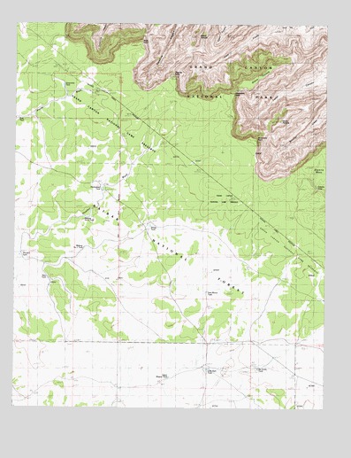
Piute Point, AZ USGS Topographic Map
Click on map above to begin viewing in our Map Viewer.

This topographic map contains these locations and features:
Feature Name Type Latitude Longitude GNIS ID View Map
Bass TankReservoirN36.0943°W112.3740°1058View Map
Diana TempleSummitN36.1118°W112.2700°3935View Map
Eremita TankReservoirN36.0717°W112.2542°4466View Map
Homestead TankReservoirN36.0715°W112.3403°5905View Map
Ike Smith TankReservoirN36.0132°W112.2771°6178View Map
Jicarilla BridgeArchN36.1078°W112.3133°2581885View Map
Jicarilla PointCliffN36.1078°W112.3124°6411View Map
Little Rain TankReservoirN36.0128°W112.2976°7163View Map
Mescalero PointCliffN36.1011°W112.2893°7925View Map
Midway Number One TankReservoirN36.0520°W112.3474°8033View Map
Midway Number Two TankReservoirN36.0622°W112.3478°8034View Map
Mimbreno PointCliffN36.0864°W112.2796°8085View Map
New TankReservoirN36.0422°W112.3617°8620View Map
Piute PointCliffN36.1178°W112.3257°9556View Map
Pollux TempleSummitN36.1206°W112.3026°9627View Map
Sam Moore TankReservoirN36.0379°W112.2981°10796View Map
Sevenmile TankReservoirN36.1049°W112.3564°11122View Map
Sheep TankReservoirN36.0593°W112.3211°11198View Map
The Ranch Airport (historical)AirportN36.0103°W112.2924°45549View Map
Thurston TankReservoirN36.0495°W112.3735°12449View Map
Upper Wagner TankReservoirN36.0101°W112.3130°21097View Map
Vesta TempleSummitN36.0935°W112.2690°13220View Map

Note: Coordinates in the location and feature list above are referenced to NAD83 datum.


Copyright (C) 2008-2025 Ryan Niemi / Sunset Dynamics ... All Rights Reserved