TopoQuest Logo
Do you find TopoQuest useful?
Help keep TopoQuest running and adding new maps/features by donating!
Bitcoin:  19c7KJd3qBynnjoSw5npx9KScwjBe4ifkT
Litecoin:  LXs6TkuXGGXo1vDsWCkWVdjQX94eUKd6ui
Home View Maps Find Maps Find Places Resources & Links


Havasupai Point, Arizona Topographic Map

USGS Map Title: Havasupai Point, AZ
USGS Map MRC: 36112B3
DRG (GeoTIFF) Download: o36112b3.tif


Neighboring USGS Topographic Map Quads:


  Powell Plateau, AZ  
36112C4
 

  King Arthur Castle, AZ  
36112C3
 

  Kanabownits Spring, AZ  
36112C2
 

  Explorers Monument, AZ  
36112B4
 

  Havasupai Point, AZ  
36112B3
 

  Shiva Temple, AZ  
36112B2
 

  Chamisa Tank, AZ  
36112A4
 

  Piute Point, AZ  
36112A3
 

  Grand Canyon, AZ  
36112A2


Map MRC Location:

N37°
W113°
N37°
W112°
H8 H7 H6 H5 H4 H3 H2 H1
G8 G7 G6 G5 G4 G3 G2 G1
F8 F7 F6 F5 F4 F3 F2 F1
E8 E7 E6 E5 E4 E3 E2 E1
D8 D7 D6 D5 D4 D3 D2 D1
C8 C7 C6 C5 C4 C3 C2 C1
B8 B7 B6 B5 B4 B3 B2 B1
A8 A7 A6 A5 A4 A3 A2 A1
N36°
W113°
N36°
W112°

Havasupai Point, AZ USGS 1:24K Topographic Map Preview:
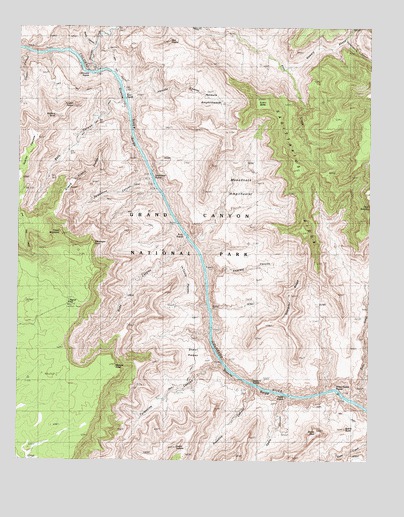
Havasupai Point, AZ USGS Topographic Map
Click on map above to begin viewing in our Map Viewer.

This topographic map contains these locations and features:
Feature Name Type Latitude Longitude GNIS ID View Map
Agate CanyonValleyN36.1437°W112.2803°500View Map
Agate RapidsRapidsN36.1441°W112.2797°24113View Map
Bass CanyonValleyN36.2290°W112.3386°1053View Map
Bass RapidsRapidsN36.2314°W112.3391°1055View Map
Burro CanyonValleyN36.2444°W112.3490°2247View Map
Castor TempleSummitN36.1288°W112.3187°2549View Map
Charybdis ButteSummitN36.1479°W112.2569°20710View Map
Copper CanyonValleyN36.2426°W112.3724°3218View Map
Dox CastleSummitN36.2456°W112.3222°20751View Map
Emerald CanyonValleyN36.1800°W112.3087°24056View Map
Emerald RapidRapidsN36.1805°W112.3094°2500898View Map
Evans ButteSummitN36.2298°W112.2914°20757View Map
Flint CreekStreamN36.2494°W112.3113°4685View Map
Fossil MountainSummitN36.1904°W112.3608°4768View Map
Gawain AbyssValleyN36.2380°W112.2789°4969View Map
Geikie PeakSummitN36.1334°W112.2692°4972View Map
Grand Scenic DivideRidgeN36.2051°W112.3567°5223View Map
Havasupai PointCliffN36.1872°W112.3493°5622View Map
Hotauta AmphitheaterBasinN36.2289°W112.3080°6044View Map
Hotauta CanyonValleyN36.2304°W112.3381°6045View Map
Huxley TerracePlainN36.2125°W112.3727°42932View Map
Kanabownits CanyonValleyN36.2462°W112.2599°6601View Map
Le Conte PlateauPlainN36.1765°W112.3154°6933View Map
Monadnock AmphitheaterBasinN36.2055°W112.2966°8199View Map
Point SublimeCapeN36.1983°W112.2510°426View Map
Ruby CanyonValleyN36.1891°W112.3159°10574View Map
Ruby RapidsRapidsN36.1900°W112.3159°24089View Map
Sagittarius RidgeRidgeN36.2281°W112.2885°10680View Map
Sapphire CanyonValleyN36.1465°W112.2916°10959View Map
Sapphire RapidsRapidsN36.1474°W112.2927°24091View Map
Scorpion RidgeRidgeN36.1730°W112.2790°11018View Map
Scylla ButteSummitN36.1346°W112.2585°11032View Map
Serpentine CanyonValleyN36.2058°W112.3283°11093View Map
Serpentine RapidsRapidsN36.2089°W112.3299°11094View Map
Shaler PlateauPlainN36.1544°W112.3213°11147View Map
Shinumo CreekStreamN36.2366°W112.3502°11223View Map
Shinumo RapidsRapidsN36.2378°W112.3541°11224View Map
Signal HillSummitN36.1704°W112.3574°11293View Map
Tuna CreekStreamN36.1428°W112.2577°12845View Map
Turquoise CanyonValleyN36.1529°W112.3028°12895View Map
Tyndall DomeSummitN36.2273°W112.3562°13020View Map
Walapai PointCliffN36.1541°W112.3427°13280View Map
Wallace ButteSummitN36.2240°W112.3629°13301View Map
Willies Necktie RapidsRapidsN36.1452°W112.2647°24108View Map

Note: Coordinates in the location and feature list above are referenced to NAD83 datum.


Copyright (C) 2008-2025 Ryan Niemi / Sunset Dynamics ... All Rights Reserved