TopoQuest Logo
Do you find TopoQuest useful?
Help keep TopoQuest running and adding new maps/features by donating!
Bitcoin:  19c7KJd3qBynnjoSw5npx9KScwjBe4ifkT
Litecoin:  LXs6TkuXGGXo1vDsWCkWVdjQX94eUKd6ui
Home View Maps Find Maps Find Places Resources & Links


Plainville, Georgia Topographic Map

USGS Map Title: Plainville, GA
USGS Map MRC: 34085D1
DRG (GeoTIFF) Download: o34085d1.tif


Neighboring USGS Topographic Map Quads:


  Subligna, GA  
34085E2
 

  Sugar Valley, GA  
34085E1
 

  Calhoun North, GA  
34084E8
 

  Armuchee, GA  
34085D2
 

  Plainville, GA  
34085D1
 

  Calhoun South, GA  
34084D8
 

  Rome North, GA  
34085C2
 

  Shannon, GA  
34085C1
 

  Adairsville, GA  
34084C8


Map MRC Location:

N35°
W86°
N35°
W85°
H8 H7 H6 H5 H4 H3 H2 H1
G8 G7 G6 G5 G4 G3 G2 G1
F8 F7 F6 F5 F4 F3 F2 F1
E8 E7 E6 E5 E4 E3 E2 E1
D8 D7 D6 D5 D4 D3 D2 D1
C8 C7 C6 C5 C4 C3 C2 C1
B8 B7 B6 B5 B4 B3 B2 B1
A8 A7 A6 A5 A4 A3 A2 A1
N34°
W86°
N34°
W85°

Plainville, GA USGS 1:24K Topographic Map Preview:
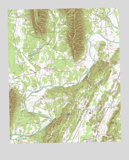
Plainville, GA USGS Topographic Map
Click on map above to begin viewing in our Map Viewer.

This topographic map contains these locations and features:
Feature Name Type Latitude Longitude GNIS ID View Map
Bell Ferry (historical)CrossingN34.3798°W85.1244°353535View Map
Bethesda ChurchChurchN34.4073°W85.0224°327085View Map
Blalocks Ferry (historical)CrossingN34.4234°W85.0924°1705451View Map
Calbeck MountainSummitN34.4984°W85.0947°331307View Map
City of PlainvilleCivilN34.4053°W85.0315°2404533View Map
CurryvillePopulated PlaceN34.4437°W85.0788°355413View Map
Curryville ChurchChurchN34.4437°W85.0822°334433View Map
Dodd CemeteryCemeteryN34.4162°W85.0877°327660View Map
Dry CreekStreamN34.4818°W85.0694°327692View Map
Everett SpringsPopulated PlaceN34.4948°W85.1138°355734View Map
Everett Springs Baptist ChurchChurchN34.4954°W85.1147°353640View Map
Franklin CemeteryCemeteryN34.4284°W85.0036°327876View Map
Georgia - Cumberland AcademySchoolN34.4657°W85.0225°327928View Map
Gordon County Fire and Rescue Department Station 3BuildingN34.4047°W85.0375°2604413View Map
Gordon County Fire and Rescue Department Station 4BuildingN34.4826°W85.0234°2604414View Map
Hickory Grove School (historical)SchoolN34.3779°W85.0349°353712View Map
Horton BendBendN34.3956°W85.0791°328230View Map
John L Coble Elementary SchoolSchoolN34.4645°W85.0209°2545790View Map
Johns CreekStreamN34.4254°W85.0891°328339View Map
Johnson Ferry (historical)CrossingN34.4281°W85.0788°334469View Map
Johnson SpringSpringN34.4693°W85.0802°334471View Map
Johnston ChapelChurchN34.4668°W85.0786°356339View Map
Johnston LakeReservoirN34.3796°W85.1131°328346View Map
Johnston Lake DamDamN34.3787°W85.1155°337064View Map
King CemeteryCemeteryN34.4262°W85.1088°353729View Map
Kings LakeReservoirN34.4370°W85.0352°328410View Map
Kings Lake DamDamN34.4393°W85.0352°337175View Map
Lakeview ChurchChurchN34.3931°W85.0244°328431View Map
Lovejoy CreekStreamN34.4226°W85.0991°328652View Map
Margie (historical)Populated PlaceN34.4012°W85.1113°353750View Map
Margie School (historical)SchoolN34.4012°W85.1091°353751View Map
Moores Ferry (historical)CrossingN34.4312°W85.0466°334477View Map
Mount Pleasant Baptist Church (historical)ChurchN34.4640°W85.1155°353775View Map
Mount Pleasant CemeteryCemeteryN34.4637°W85.1155°353776View Map
Mount Vernon CemeteryCemeteryN34.4009°W85.1083°353780View Map
Mount Vernon ChurchChurchN34.4006°W85.1086°328904View Map
Mount Zion ChurchChurchN34.4520°W85.0611°328917View Map
Muck CreekStreamN34.4318°W85.1094°328938View Map
New Everett Springs CemeteryCemeteryN34.4929°W85.1133°353792View Map
New Hope CemeteryCemeteryN34.4381°W85.1058°353793View Map
New Hope ChurchChurchN34.4379°W85.1052°329004View Map
Old Everett Springs CemeteryCemeteryN34.4954°W85.1152°353809View Map
OostanaulaPopulated PlaceN34.4815°W85.0144°356447View Map
Oostanaula ChurchChurchN34.4873°W85.0252°329100View Map
Oostanaula School (historical)SchoolN34.4820°W85.0238°334485View Map
PlainvillePopulated PlaceN34.4051°W85.0372°332706View Map
Plainville Consolidated School (historical)SchoolN34.4034°W85.0333°334493View Map
Plainville Road CemeteryCemeteryN34.3893°W85.0430°353826View Map
Poplar Spring School (historical)SchoolN34.4159°W85.0827°334495View Map
Printup Ferry (historical)CrossingN34.4920°W85.0133°334496View Map
ReevesPopulated PlaceN34.4615°W85.0127°356492View Map
Reeves Baptist ChurchChurchN34.4618°W85.0105°334498View Map
Reeves CemeteryCemeteryN34.4598°W85.0227°329396View Map
Riverside AirportAirportN34.4290°W85.0551°351878View Map
Robbins CreekStreamN34.4501°W85.0274°329449View Map
Rocky CreekStreamN34.4315°W85.0911°329491View Map
Rocky Creek (historical)Populated PlaceN34.4712°W85.0674°334499View Map
RosedalePopulated PlaceN34.4384°W85.1080°332923View Map
Rutledge LakeReservoirN34.3761°W85.0929°337047View Map
Rutledge Lake DamDamN34.3768°W85.0933°337046View Map
Scott CemeteryCemeteryN34.4165°W85.0405°329618View Map
Scott LakeReservoirN34.3987°W85.0257°339770View Map
Scott Lake DamDamN34.3990°W85.0266°339769View Map
Spring BranchStreamN34.4818°W85.0694°329790View Map
Sunnyside ChurchChurchN34.3815°W85.0788°329895View Map
Todd LakeReservoirN34.4662°W85.0861°339768View Map
Todd Lake DamDamN34.4634°W85.0899°339767View Map
Turkey MountainSummitN34.4115°W85.1241°333283View Map
W L Swain Elementary SchoolSchoolN34.4385°W85.0024°334518View Map
WarrenPopulated PlaceN34.3862°W85.0480°353921View Map
West Union ChurchChurchN34.4695°W85.0819°356630View Map

Note: Coordinates in the location and feature list above are referenced to NAD83 datum.


Copyright (C) 2008-2024 Ryan Niemi / Sunset Dynamics ... All Rights Reserved