TopoQuest Logo
Do you find TopoQuest useful?
Help keep TopoQuest running and adding new maps/features by donating!
Bitcoin:  19c7KJd3qBynnjoSw5npx9KScwjBe4ifkT
Litecoin:  LXs6TkuXGGXo1vDsWCkWVdjQX94eUKd6ui
Home View Maps Find Maps Find Places Resources & Links


Subligna, Georgia Topographic Map

USGS Map Title: Subligna, GA
USGS Map MRC: 34085E2
DRG (GeoTIFF) Download: o34085e2.tif


Neighboring USGS Topographic Map Quads:


  LaFayette, GA  
34085F3
 

  Catlett, GA  
34085F2
 

  Villanow, GA  
34085F1
 

  Trion, GA  
34085E3
 

  Subligna, GA  
34085E2
 

  Sugar Valley, GA  
34085E1
 

  Summerville, GA  
34085D3
 

  Armuchee, GA  
34085D2
 

  Plainville, GA  
34085D1


Map MRC Location:

N35°
W86°
N35°
W85°
H8 H7 H6 H5 H4 H3 H2 H1
G8 G7 G6 G5 G4 G3 G2 G1
F8 F7 F6 F5 F4 F3 F2 F1
E8 E7 E6 E5 E4 E3 E2 E1
D8 D7 D6 D5 D4 D3 D2 D1
C8 C7 C6 C5 C4 C3 C2 C1
B8 B7 B6 B5 B4 B3 B2 B1
A8 A7 A6 A5 A4 A3 A2 A1
N34°
W86°
N34°
W85°

Subligna, GA USGS 1:24K Topographic Map Preview:
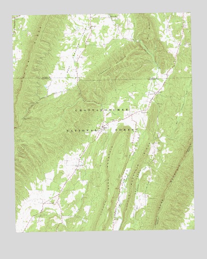
Subligna, GA USGS Topographic Map
Click on map above to begin viewing in our Map Viewer.

This topographic map contains these locations and features:
Feature Name Type Latitude Longitude GNIS ID View Map
Baileys GapGapN34.5623°W85.2080°344418View Map
BeatumPopulated PlaceN34.5793°W85.1491°331116View Map
Bethlehem Baptist ChurchChurchN34.5790°W85.1508°354689View Map
Bethlehem CemeteryCemeteryN34.5790°W85.1516°344421View Map
Dick CreekStreamN34.6006°W85.1516°327640View Map
Dry Creek ValleyValleyN34.5059°W85.1664°327697View Map
East Armuchee ValleyValleyN34.5532°W85.1400°327729View Map
Emmaus Church (historical)ChurchN34.5704°W85.1875°344439View Map
Emmaus Mill (historical)LocaleN34.5718°W85.1880°344440View Map
Fishers ChapelChurchN34.5501°W85.1522°327824View Map
Hammond GapGapN34.5656°W85.2436°356155View Map
Johns MountainSummitN34.5215°W85.1441°332106View Map
Johnson School (historical)SchoolN34.5123°W85.2291°344457View Map
Lawrence Mill (historical)LocaleN34.5784°W85.2027°344460View Map
Laws Mill (historical)LocaleN34.5726°W85.1883°344461View Map
Little Mountain RidgeRidgeN34.5323°W85.1661°328562View Map
Marstellers Mill (historical)LocaleN34.5998°W85.1525°354120View Map
Mills CemeteryCemeteryN34.5073°W85.1805°328808View Map
Mount Joy CemeteryCemeteryN34.5723°W85.1455°328875View Map
Narrows Picnic AreaLocaleN34.5745°W85.2352°328974View Map
NewLocaleN34.5381°W85.2052°328989View Map
Pleasant Hill CemeteryCemeteryN34.6176°W85.1955°354172View Map
Pleasant Hill ChurchChurchN34.6179°W85.1941°329262View Map
Pleasant Hill Zion ChurchChurchN34.5090°W85.2327°329267View Map
Roys Mill (historical)LocaleN34.6023°W85.1516°354189View Map
Ruff CreekStreamN34.5556°W85.1594°329543View Map
Ruffs Creek Mill (historical)LocaleN34.5823°W85.2041°344484View Map
Salmon CemeteryCemeteryN34.5184°W85.1566°329577View Map
Strawberry MountainSummitN34.5973°W85.1736°329871View Map
SublignaPopulated PlaceN34.5601°W85.1875°329874View Map
Subligna CemeteryCemeteryN34.5642°W85.1788°329875View Map
Subligna ChurchChurchN34.5173°W85.2313°344491View Map
Subligna Junior High School (historical)SchoolN34.5587°W85.1872°344492View Map
Subligna Volunteer Fire DepartmentBuildingN34.5601°W85.1878°2603546View Map
WatervillePopulated PlaceN34.6240°W85.2483°354222View Map
Waterville SpringSpringN34.6234°W85.2488°354224View Map
West Armuchee ValleyValleyN34.5783°W85.2257°330210View Map

Note: Coordinates in the location and feature list above are referenced to NAD83 datum.


Copyright (C) 2008-2024 Ryan Niemi / Sunset Dynamics ... All Rights Reserved