TopoQuest Logo
Do you find TopoQuest useful?
Help keep TopoQuest running and adding new maps/features by donating!
Bitcoin:  19c7KJd3qBynnjoSw5npx9KScwjBe4ifkT
Litecoin:  LXs6TkuXGGXo1vDsWCkWVdjQX94eUKd6ui
Home View Maps Find Maps Find Places Resources & Links


Bettles Well, Nevada Topographic Map

USGS Map Title: Bettles Well, NV
USGS Map MRC: 38117D8
DRG (GeoTIFF) Download: o38117d8.tif


Neighboring USGS Topographic Map Quads:


  Sunrise Flat, NV  
38118E1
 

  Stewart Spring, NV  
38117E8
 

  Simon, NV  
38117E7
 

  Mina, NV  
38118D1
 

  Bettles Well, NV  
38117D8
 

  Dicalite Summit, NV  
38117D7
 

  Sodaville, NV  
38118C1
 

  Eddyville, NV  
38117C8
 

  Kibby Flat, NV  
38117C7


Map MRC Location:

N39°
W118°
N39°
W117°
H8 H7 H6 H5 H4 H3 H2 H1
G8 G7 G6 G5 G4 G3 G2 G1
F8 F7 F6 F5 F4 F3 F2 F1
E8 E7 E6 E5 E4 E3 E2 E1
D8 D7 D6 D5 D4 D3 D2 D1
C8 C7 C6 C5 C4 C3 C2 C1
B8 B7 B6 B5 B4 B3 B2 B1
A8 A7 A6 A5 A4 A3 A2 A1
N38°
W118°
N38°
W117°

Bettles Well, NV USGS 1:24K Topographic Map Preview:
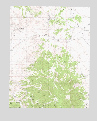
Bettles Well, NV USGS Topographic Map
Click on map above to begin viewing in our Map Viewer.

This topographic map contains these locations and features:
Feature Name Type Latitude Longitude GNIS ID View Map
Bettles MineMineN38.3796°W117.9993°849764View Map
Bettles Ranch SpringSpringN38.4138°W117.8803°864000View Map
Bettles WellWellN38.4633°W117.9537°845763View Map
Black Jack SpringSpringN38.4323°W117.9165°849773View Map
Cedar Mountain WellWellN38.4705°W117.8834°849775View Map
Cinnabar SpringSpringN38.3805°W117.9458°849769View Map
Clay Peters MineMineN38.4835°W117.9423°849778View Map
Copper Chief MineMineN38.4724°W117.9846°849776View Map
Corner SpringSpringN38.4124°W117.9690°851873View Map
Coveney MineMineN38.3785°W117.9387°849771View Map
Davis SpringSpringN38.3828°W117.9583°849768View Map
Drew MineMineN38.3810°W117.9273°854744View Map
Garnet MineMineN38.3927°W117.8884°853432View Map
Graham SpringSpringN38.4163°W117.8915°864949View Map
Gunmetal MineMineN38.3863°W117.8904°849772View Map
Keg MineMineN38.3780°W117.9487°849770View Map
Klondike (historical)LocaleN38.4849°W117.9398°851896View Map
Kope Scheelite MineMineN38.4844°W117.9432°853431View Map
Lakeview MineMineN38.3924°W117.9229°854745View Map
Lindsey MineMineN38.3863°W117.8979°841649View Map
Mammoth MineMineN38.3752°W117.9834°854872View Map
Millsite SpringSpringN38.3855°W117.9651°849767View Map
Mitchell SpringSpringN38.4274°W117.9176°851876View Map
Mitchell SpringSpringN38.4367°W117.9207°849774View Map
Pilot Mountains Mining DistrictCivilN38.3916°W117.9393°856592View Map
Point of Hill SpringSpringN38.3955°W117.8782°853484View Map
Redwing MineMineN38.4649°W117.9976°853430View Map
Roadside SpringSpringN38.3993°W117.9819°849766View Map
South Mitchell SpringSpringN38.4060°W117.8804°851875View Map
Sullivans Camp (historical)LocaleN38.4663°W117.9932°851917View Map
Table MountainSummitN38.4949°W117.9834°845693View Map
Taylor SpringSpringN38.4438°W117.9298°851871View Map
Tim Holt SummitGapN38.4805°W117.9412°849777View Map
Warner Corral SpringSpringN38.3817°W117.9898°849765View Map
Wild Cat SpringSpringN38.4274°W117.9865°851872View Map
Yellow SpringSpringN38.3758°W117.9614°851874View Map

Note: Coordinates in the location and feature list above are referenced to NAD83 datum.


Copyright (C) 2008-2025 Ryan Niemi / Sunset Dynamics ... All Rights Reserved