TopoQuest Logo
Do you find TopoQuest useful?
Help keep TopoQuest running and adding new maps/features by donating!
Bitcoin:  19c7KJd3qBynnjoSw5npx9KScwjBe4ifkT
Litecoin:  LXs6TkuXGGXo1vDsWCkWVdjQX94eUKd6ui
Home View Maps Find Maps Find Places Resources & Links


Beulah, Colorado Topographic Map

USGS Map Title: Beulah, CO
USGS Map MRC: 38104A8
DRG (GeoTIFF) Download: o38104a8.tif


Neighboring USGS Topographic Map Quads:


  Wetmore, CO  
38105B1
 

  Owl Canyon, CO  
38104B8
 

  Beulah NE, CO  
38104B7
 

  Saint Charles Peak, CO  
38105A1
 

  Beulah, CO  
38104A8
 

  Muldoon Hill, CO  
38104A7
 

  San Isabel, CO  
37105H1
 

  Rye, CO  
37104H8
 

  Colorado City, CO  
37104H7


Map MRC Location:

N39°
W105°
N39°
W104°
H8 H7 H6 H5 H4 H3 H2 H1
G8 G7 G6 G5 G4 G3 G2 G1
F8 F7 F6 F5 F4 F3 F2 F1
E8 E7 E6 E5 E4 E3 E2 E1
D8 D7 D6 D5 D4 D3 D2 D1
C8 C7 C6 C5 C4 C3 C2 C1
B8 B7 B6 B5 B4 B3 B2 B1
A8 A7 A6 A5 A4 A3 A2 A1
N38°
W105°
N38°
W104°

Beulah, CO USGS 1:24K Topographic Map Preview:
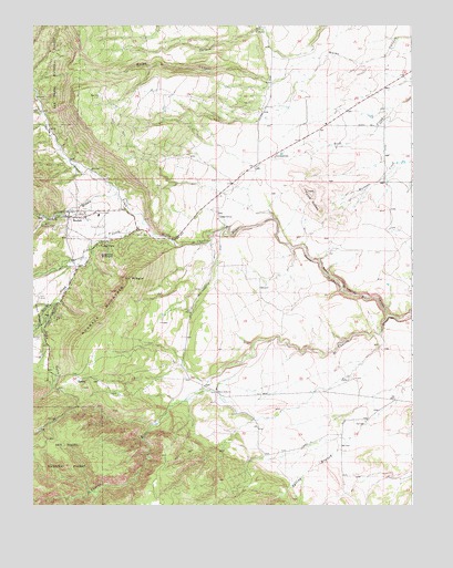
Beulah, CO USGS Topographic Map
Click on map above to begin viewing in our Map Viewer.

This topographic map contains these locations and features:
Feature Name Type Latitude Longitude GNIS ID View Map
BeulahPopulated PlaceN38.0750°W104.9867°204803View Map
Beulah CemeteryCemeteryN38.0712°W104.9651°193825View Map
Beulah Emergency Medical ServicesBuildingN38.0757°W104.9783°2695585View Map
Beulah HillSummitN38.0706°W104.9519°193830View Map
Beulah Post OfficePost OfficeN38.0753°W104.9863°2750863View Map
Beulah ValleyPopulated PlaceN38.0722°W104.9664°1852838View Map
Beulah Valley Census Designated PlaceCensusN38.0665°W104.9785°2407835View Map
Beulah Valley Volunteer Fire DepartmentBuildingN38.0751°W104.9882°2666981View Map
Cedar GrovePopulated PlaceN38.0750°W104.9389°193832View Map
Dotson Ditch Number 1CanalN38.0302°W104.9401°2712008View Map
Game GulchValleyN38.0525°W104.9930°192385View Map
Good Pasture Airport (historical)AirportN38.0972°W104.9105°204265View Map
GoodpasturePopulated PlaceN38.0833°W104.9200°193822View Map
Hogback MountainSummitN38.0475°W104.9786°193829View Map
Little Saint Charles CreekStreamN38.0020°W104.9892°192529View Map
Middle CreekStreamN38.0736°W104.9639°192357View Map
Mount SignalSummitN38.0592°W104.9680°193828View Map
North CreekStreamN38.0808°W104.9730°192356View Map
North Saint Charles CanyonValleyN38.0493°W104.8835°193833View Map
North Saint Charles RiverStreamN38.0492°W104.8833°193831View Map
Panther CreekStreamN38.1025°W104.9972°192367View Map
Siloam Clay MineMineN38.1064°W104.9300°1734099View Map
Sitton CornerLocaleN38.0167°W104.9005°196555View Map
South CreekStreamN38.0628°W104.9850°192380View Map
Squirrel CreekStreamN38.0736°W104.9639°192374View Map
Sugarloaf MountainSummitN38.0653°W104.9778°193827View Map
Three R RanchLocaleN38.0297°W104.9394°193834View Map
Turtle ButtesSummitN38.0820°W104.9094°193823View Map
Valley ViewPopulated PlaceN38.0683°W104.9769°193826View Map

Note: Coordinates in the location and feature list above are referenced to NAD83 datum.


Copyright (C) 2008-2025 Ryan Niemi / Sunset Dynamics ... All Rights Reserved